Filtered by:
- Lots with images only,
- Category
- List
- Grid
A subscription to the Price Guide is required to view results for auctions ten days or older. Click here for more information
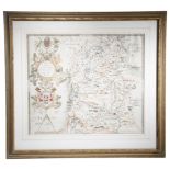

'WILTONIA' AN ENGRAVED MAP OF WILTSHIRE BY CHRISTOPHER SAXTON (C.1540 - C.1610) engraved by Remigius
'WILTONIA' AN ENGRAVED MAP OF WILTSHIRE BY CHRISTOPHER SAXTON (C.1540 - C.1610) engraved by Remigius Hogenbergius, hand-coloured, with a strap-wor...
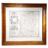
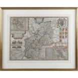
'WILTONIAE' AN ENGRAVED MAP OF WILTSHIRE BY CHRISTOPHER SAXTON (C.1540 - C.1610) engraved by
'WILTONIAE' AN ENGRAVED MAP OF WILTSHIRE BY CHRISTOPHER SAXTON (C.1540 - C.1610) engraved by Remigius Hogenbergius, hand-coloured, with a strap-wo...
'WILSHIRE' AN ENGRAVED MAP BY JOHN SPEED (1552-1629) a hand-coloured map of Wiltshire, with a plan
'WILSHIRE' AN ENGRAVED MAP BY JOHN SPEED (1552-1629) a hand-coloured map of Wiltshire, with a plan of Salisbury and a view of Stonehenge, sold by ...
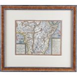
'CERETICA SIVE CARDIGANENSIS' AN ENGRAVED MAPAFTER JOHANNES BLAEU (DUTCH 1571-1638), C.1645 hand-coloured and depicting Cardiganshire, in a later ...
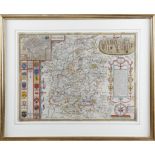
'GLOCESTERSHIRE' AN ENGRAVED MAP BY JOHN SPEED (1552-1629) a hand-coloured map of Gloucestershire,
'GLOCESTERSHIRE' AN ENGRAVED MAP BY JOHN SPEED (1552-1629) a hand-coloured map of Gloucestershire, with plans of Gloucester and Bristow, sold by J...
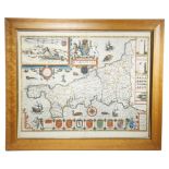
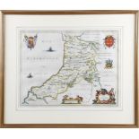
'CORNWALL' AN ENGRAVED MAP BY JOHN SPEED (1552-1629) a hand-coloured engraved map with an inset view
'CORNWALL' AN ENGRAVED MAP BY JOHN SPEED (1552-1629) a hand-coloured engraved map with an inset view of Launceston, English text to verso, dated '...
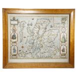
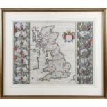
'THE KINGDOME OF SCOTLAND' AN ENGRAVED MAP BY JOHN SPEED (1552-1629) hand-coloured, with an inset
'THE KINGDOME OF SCOTLAND' AN ENGRAVED MAP BY JOHN SPEED (1552-1629) hand-coloured, with an inset view of the Isles of Orkney, English text to ve...
'REGIONIS QUAE EST CIRCA LONDINUM' AN ENGRAVED MAP OF LONDON AFTER JOHANN HOMANN (GERMAN 1664-
'REGIONIS QUAE EST CIRCA LONDINUM' AN ENGRAVED MAP OF LONDON AFTER JOHANN HOMANN (GERMAN 1664-1724) published by Homann Heirs and dated '1741', ha...
'MIDDLESEX' AN ENGRAVED MAP BY RICHARD WILLIAM SEALE (1703-1762) hand-coloured, depicting the county
'MIDDLESEX' AN ENGRAVED MAP BY RICHARD WILLIAM SEALE (1703-1762) hand-coloured, depicting the county and the city of London, with city coat of arm...
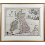
'LES ISLES BRITANNIQUES' AN ENGRAVED MAP BY JAN BAREND ELWE (DUTCH 1777-1815) hand-coloured, with an
'LES ISLES BRITANNIQUES' AN ENGRAVED MAP BY JAN BAREND ELWE (DUTCH 1777-1815) hand-coloured, with an inset view of the Isles of Orkney, Shetland I...
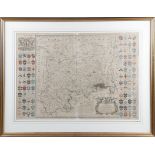
'BRITTANIA' AN ENGRAVED MAP BY JOHANNES BLAEU (DUTCH 1596-1673) hand-coloured, with fourteen
'BRITTANIA' AN ENGRAVED MAP BY JOHANNES BLAEU (DUTCH 1596-1673) hand-coloured, with fourteen cartouches depicting Saxon figures and events, with L...
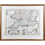
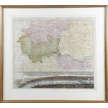
'PARTE MERIDIONALE DEL REGNO D'INGHILTERRA' AN ENGRAVED MAP BY VINCENZO CORONELLI (ITALIAN 1650-
'PARTE MERIDIONALE DEL REGNO D'INGHILTERRA' AN ENGRAVED MAP BY VINCENZO CORONELLI (ITALIAN 1650-1718) hand-coloured, depicting southern England & ...
'ORDNANCE SURVEY 1-INCH SEVENTH SERIES MAPS' C.1991 limited edition, number 45 out of 65, the set
'ORDNANCE SURVEY 1-INCH SEVENTH SERIES MAPS' C.1991 limited edition, number 45 out of 65, the set contains a hundred and forty-nine maps which tog...
'ABYSSINORUM' AN ENGRAVED MAP OF ABYSSINIA PUBLISHED BY JOHANN BUSSEMACHER (GERMAN FL.1580-1613)
'ABYSSINORUM' AN ENGRAVED MAP OF ABYSSINIA PUBLISHED BY JOHANN BUSSEMACHER (GERMAN FL.1580-1613) AFTER M. QUAD dated '1600' and hand-coloured, wit...
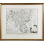
'L'ASIA DIVISA NE'SUOI PRINCIPALI STATI' AN ENGRAVED MAP BY ANTONIO ZATTA (ITALIAN FL. 1757-1797)
'L'ASIA DIVISA NE'SUOI PRINCIPALI STATI' AN ENGRAVED MAP BY ANTONIO ZATTA (ITALIAN FL. 1757-1797) hand-coloured and dated 'Venezia 1777', in a lat...
A MODERN MAP OF THE 'CAMINO DE SANTIAGO' IN 17TH CENTURY STYLE BY DANIEL DERVEAUX (FRENCH D.2010),
A MODERN MAP OF THE 'CAMINO DE SANTIAGO' IN 17TH CENTURY STYLE BY DANIEL DERVEAUX (FRENCH D.2010), PUBLISHED IN FRANCE IN 1975; imitating the old ...
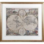
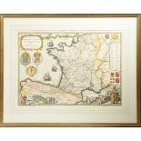
'NOVA ORBIS TABULA IN LUCEM EDITA' AN ENGRAVED MAP OF THE WORLD BY FREDERICK DE WIT (DUTCH 1630-
'NOVA ORBIS TABULA IN LUCEM EDITA' AN ENGRAVED MAP OF THE WORLD BY FREDERICK DE WIT (DUTCH 1630-1706) ,C.1670 second state, hand-coloured, depicti...