Filtered by:
- Category
- List
- Grid
A subscription to the Price Guide is required to view results for auctions ten days or older. Click here for more information
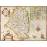

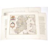
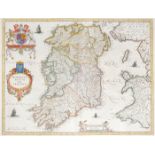
1632 Map of Leinster by John Speed. A hand-coloured, engraved map, 'The Countie of Leinster with the
1632 Map of Leinster by John Speed. A hand-coloured, engraved map, 'The Countie of Leinster with the Citie Dublin Described', printed by John Daws...
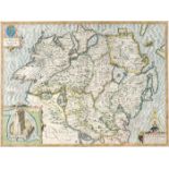
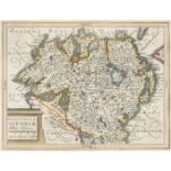
Early 17th century, map of Ulster by John Speed. John Speed 17th Century engraved and hand-coloured map of the province of Ulster with an inset ob...
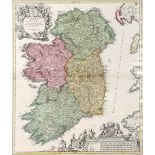
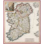
1646 Map of Ireland, by Joannes Jansson. A hand-coloured engraved map, `Hibernia Regnum Vulgo Ireland`, based on Speed`s earlier work, as publishe...
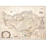
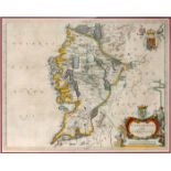
1646 Map of Connaught, by Joannes Jansson. A hand-coloured engraved map, `Provincia Connachtiae -
1646 Map of Connaught, by Joannes Jansson. A hand-coloured engraved map, `Provincia Connachtiae - The Province of Connaugt`, based on Speed`s earl...
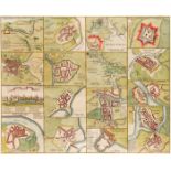
1654 Maps of Ireland by Joan Blaeu, from Theatrum or Novus Atlas. A set of six hand-coloured, engraved maps of Ireland, Ulster; Munster, Connaught...
1654 Map of Connaught by Joan Bleau. A hand-coloured, engraved map of 'Connachtia Vulgo Connaughty',
1654 Map of Connaught by Joan Bleau. A hand-coloured, engraved map of 'Connachtia Vulgo Connaughty', in the first state, as published in the 1654 ...
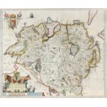
1654 Map of Ulster, by Joan Blaeu. A hand-coloured, engraved map of 'Vultonia; Hibernis Cujgujlly;
1654 Map of Ulster, by Joan Blaeu. A hand-coloured, engraved map of 'Vultonia; Hibernis Cujgujlly; Anglis Vlster', in the first state as published...
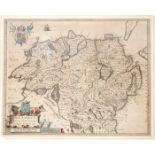
1654 Map of Ulster, by Joan Blaeu. A hand-coloured, engraved map of 'Vultonia; Hibernis Cujgujlly;
1654 Map of Ulster, by Joan Blaeu. A hand-coloured, engraved map of 'Vultonia; Hibernis Cujgujlly; Anglis Vlster', in the first state as published...
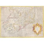
1654 Map of Leinster by Joan Blaeu. A hand-coloured, engraved map Leinster, in the first state as
1654 Map of Leinster by Joan Blaeu. A hand-coloured, engraved map Leinster, in the first state as published in the 1654 fifth volume of Novus Atla...
Mid 17th century maps of Leinster and Ulster, after Mercator. Maps of Leinster and Ulster from the
Mid 17th century maps of Leinster and Ulster, after Mercator. Maps of Leinster and Ulster from the Mercator Hondius “Atlas Minor” published in Ams...
17th Century Map. Mercator, Gerhardt. Irlandiae Regnum. c1620. South sheet, later coloured. Unframed. 13¼ x 18½in. (33.66 x 46.99cm)
17th century, Hiberniae, Map of Ireland by William Camden and a city plan of Limerick. Hiberniae
17th century, Hiberniae, Map of Ireland by William Camden and a city plan of Limerick. Hiberniae Ireland Anglis Yvrndon Britannis Erin incolis... ...
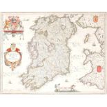
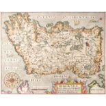
1662 Map of Ireland by Joan Blaeu A hand-coloured, engraved map of Ireland, in the second state as
1662 Map of Ireland by Joan Blaeu A hand-coloured, engraved map of Ireland, in the second state as published in Atlas Mayor, 1662, Latin edition, ...
1695 The Kingdom of Ireland, by Robert Morden. A hand-coloured, engraved map, from Camden's Britannia, 1695, with Newry spelt 'Nury' reverse blank...
17th and 18th century, Yorkshire, Schenk and Valk map and Greenvile Collins sea chart. Collins (
17th and 18th century, Yorkshire, Schenk and Valk map and Greenvile Collins sea chart. Collins (Greenvile) Burlington Bay, Scarbrough & Hartlepool...
1695 The Kingdom of Ireland, by Robert Morden. A hand-coloured, engraved map, from Camden's Britannia, 1695, with Newry spelt 'Nury', reverse blan...
1720, Map of Ireland by Johann Baptiste Homann. A hand-coloured, engraved map of Ireland, 'Hiberniae
1720, Map of Ireland by Johann Baptiste Homann. A hand-coloured, engraved map of Ireland, 'Hiberniae Regnum tam in praecipuas, Ultoniae, Connaciae...
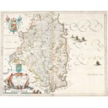
1732 Map of County Kerry by William Petty. A hand-coloured, engraved map, "The County of Kerry",
1732 Map of County Kerry by William Petty. A hand-coloured, engraved map, "The County of Kerry", as published by George Grierson, Dublin, 1731, mo...
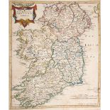
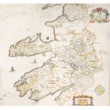
1740 A New Map of Ireland, by Herman Moll. A hand coloured engraved map of Ireland, divided into its
1740 A New Map of Ireland, by Herman Moll. A hand coloured engraved map of Ireland, divided into its Provinces, Counties and Baronies. Inset plans...
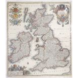
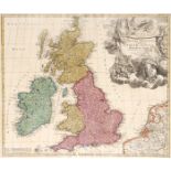
Circa 1740 Map of Britain and Ireland, by Matthias Seutter Georg Matthias Seutter - Tabula Novissima
Circa 1740 Map of Britain and Ireland, by Matthias Seutter Georg Matthias Seutter - Tabula Novissima Accuratissima. Regnorum Angliae, Scotiae, Hib...
1740 Map of Britain and Ireland, by Johan Baptiste Homann. A hand-coloured, engraved map of the
1740 Map of Britain and Ireland, by Johan Baptiste Homann. A hand-coloured, engraved map of the British Isles, "Magna Britannia, Anglia Scotiae & ...
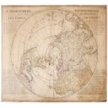
1740 L' Hemisphere Septentrional pour voir plus distinctement les Terres Arctiques. By Guillaume
1740 L' Hemisphere Septentrional pour voir plus distinctement les Terres Arctiques. By Guillaume de L'Isle; Ivan Kyrilov; Jean Cóvens; Corneille M...
1743 Map of Ireland, by Guillaume de Lisle. A hand-coloured, engraved map of Ireland, 'Irlanda',
1743 Map of Ireland, by Guillaume de Lisle. A hand-coloured, engraved map of Ireland, 'Irlanda', from 'Storio Moderna overo lo Stao Presentedi tut...
1709-1829 Estate maps of lands in Cavan, Longford, Monaghan and Wexford. Hand-coloured estate
1709-1829 Estate maps of lands in Cavan, Longford, Monaghan and Wexford. Hand-coloured estate maps, Portanure, Co. Cavan - Longford, 1709, by Dani...
1759-1801 Maps of Ireland and Wexford and plans of the Principal Ports, Towns and Harbours of
1759-1801 Maps of Ireland and Wexford and plans of the Principal Ports, Towns and Harbours of Ireland. Ireland divided in provinces and counties, ...
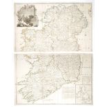
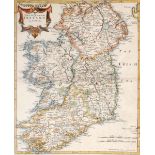
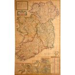
Circa 1760 Map of Ireland, by John Rocque The Kingdom of Ireland Divided into Provinces Counties and
Circa 1760 Map of Ireland, by John Rocque The Kingdom of Ireland Divided into Provinces Counties and Baronies. Showing the Archbishopricks, Bishop...
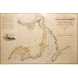
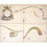
1835 Chart of Waterford Harbour A hand-coloured engraved chart of Waterford Harbour, as surveyed
1835 Chart of Waterford Harbour A hand-coloured engraved chart of Waterford Harbour, as surveyed by Samson Carter & Nobbett St. Leger, Engineers, ...