44
Taylor & Skinner`s Maps of the Roads of Ireland, Surveyed 1777. G. Nicol, London, and W. Wilson,

Description
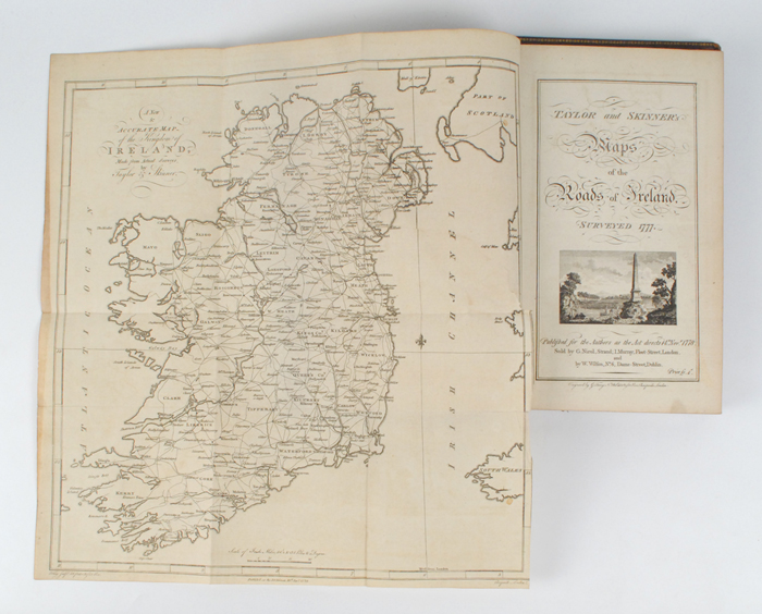
Taylor & Skinner`s Maps of the Roads of Ireland, Surveyed 1777.
G. Nicol, London, and W. Wilson, Dublin, 14th November 1778. First edition. With folding map of Ireland at front and 288 pages of copperplate engraved road maps. Royal octavo; contemporary roan over marbled boards with gilt tooling at spine, covers split from spine. With bookplate of Henry Alexander of Forkill in The County of Armagh Esqr.1840".
P
Auction Details
Shipping
T&Cs & Important Info
Ask seller a question
Taylor & Skinner`s Maps of the Roads of Ireland, Surveyed 1777.
G. Nicol, London, and W. Wilson, Dublin, 14th November 1778. First edition. With folding map of Ireland at front and 288 pages of copperplate engraved road maps. Royal octavo; contemporary roan over marbled boards with gilt tooling at spine, covers split from spine. With bookplate of Henry Alexander of Forkill in The County of Armagh Esqr.1840".
P
History, Literature and Collectibles
Sale Date(s)
Venue Address
38 Molesworth Street
Dublin 2
.
Ireland
General delivery information available from the auctioneer
The buyer will be responsible for all removal, storage and insurance charges in respect of any lot which has not been collected within fourteen days of the date of sale.
Important Information
Buyers Premium: 25% including VAT (20.3% + 23%VAT)
Shipping:
Whytes do not handle this themselves but will recommend a suitable company who can collect your purchases on your behalf and pack and despatch them to you once they have been paid for.
Shipping:
Whytes do not handle this themselves but will recommend a suitable company who can collect your purchases on your behalf and pack and despatch them to you once they have been paid for.