Filtered by:
- Category,
- Creator / Brand
- List
- Grid
A subscription to the Price Guide is required to view results for auctions ten days or older. Click here for more information

Large Quantity of Original Blueprint Ships Plans including plans for converting WW1 ships and
Large Quantity of Original Blueprint Ships Plans including plans for converting WW1 ships and alterations of ships for trooping duties in WW2, dat...
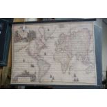
Canvas Hanging Banner depicting an Antique Map of the World after Gerard van Keulen, supported on
Canvas Hanging Banner depicting an Antique Map of the World after Gerard van Keulen, supported on wooden poles, 95cms x 70cms

Four similar 19th century Ale Drinking Glasses with Wheel Engraving, 19cms high
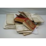
Approximately 36 Mid 20th century Folded Road Maps including 1921 Wartime Map together with approx. 21 Navigation Charts

Books - 1903 Copy of ' The Survey Atlas of England and Wales ' with 84 plates of maps and plans
Books - 1903 Copy of ' The Survey Atlas of England and Wales ' with 84 plates of maps and plans designed under the direction of J G Bartholomew: 1...
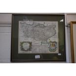
Early Georgian Map of Kent, printed by Thomas Rycroft in 16743, drawn by Richard Blome