Filtered by:
- Sale Section,
- Category
- List
- Grid
A subscription to the Price Guide is required to view results for auctions ten days or older. Click here for more information
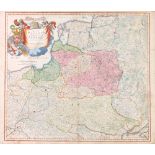

Homanno (Johann Baptiste): 18th century Map of Poland and Lithuania, coloured steel engraving,
Homanno (Johann Baptiste): 18th century Map of Poland and Lithuania, coloured steel engraving, framed, 60cm x 50cm. CONDITION REPORT: Framed an...
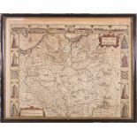
JOHN SPEEDE New Map of Poland, annotated to scaled key 'a humble 1626', framed, 54cm x 24cm,
JOHN SPEEDE New Map of Poland, annotated to scaled key 'a humble 1626', framed, 54cm x 24cm, Edward Gordon label verso. CONDITION REPORT: Centr...
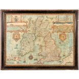
JOHN SPEEDE Map of 'The Kingdome of Great Britain and Ireland' to be sold by 'The Bafsett in Fleet
JOHN SPEEDE Map of 'The Kingdome of Great Britain and Ireland' to be sold by 'The Bafsett in Fleet Street and Ric Chifwell in St Pauls church yard...
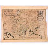
New map of Poland, Hungary, Walachia, Moldavia little Tartary dedicated to his Highness William Duke of Gloucester, coloured engraving, unframed, ...
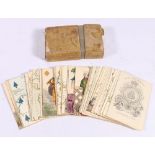
Charles Hodges early 19th century Geographical cards by Stopforth & Son, London, the engraved cards with square corners and plain backs, gilt edge...
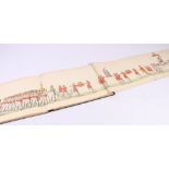
Winemaking Fete - La Fête des Vignerons, Vevey, hand coloured engraved panoramia in fifteen joined double sections, each 18.5cm x 47cm, card cover...