Filtered by:
- Category,
- Item Type
- List
- Grid
A subscription to the Price Guide is required to view results for auctions ten days or older. Click here for more information
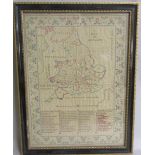

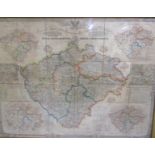
An early 19th Century needlework map of England and Wales with counties detailed and numbered
An early 19th Century needlework map of England and Wales with counties detailed and numbered relating to an index of English and Welsh counties. ...
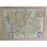
A map of Hertfordshire engraved from an actual survey with improvements. London engraved for J
A map of Hertfordshire engraved from an actual survey with improvements. London engraved for J Harrison, 115 Newgate Street. July 4th 1788 with ...
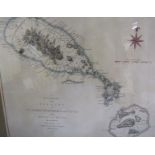
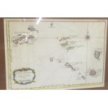
An accurate map of the Islands of St. Christophers & Nevis in the West Indies by an officer with the
An accurate map of the Islands of St. Christophers & Nevis in the West Indies by an officer with the position of the English and French fleets, Fe...
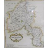
A Robert Morden map of Oxfordshire with a scale of miles, sold by Abel Swale Aronsham and John
A Robert Morden map of Oxfordshire with a scale of miles, sold by Abel Swale Aronsham and John Churchil. Framed and glazed 43cms x 37cms.
A map Petites Antilles Ou Isles du Vent being Tome I. 82. Framed and glazed 23cms x 33cms.
A Christopher Saxton and Philip Lea map of Merioneth and Montgomery with inset town plans of
A Christopher Saxton and Philip Lea map of Merioneth and Montgomery with inset town plans of Montgomery and Harlich. Framed and glazed 35cms x 45...
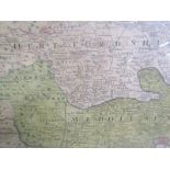
An 18th Century Thos. Bawles/Homann map of London, England and Environs with inset panorama of
An 18th Century Thos. Bawles/Homann map of London, England and Environs with inset panorama of London Westminster. Framed and glazed 53cms x 59cm...
A 19th Century coloured map of Bohemia c.1850 General-Diberlichts-Karte Des Konigreiches Bohmen -
A 19th Century coloured map of Bohemia c.1850 General-Diberlichts-Karte Des Konigreiches Bohmen - coloured paper on linen originally folded, now f...