Filtered by:
- Category,
- Item Type
- List
- Grid
A subscription to the Price Guide is required to view results for auctions ten days or older. Click here for more information
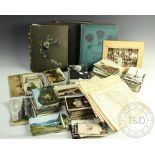

A collection of Edwardian and later postcards, in three albums and loose, including some of actresses and actors; with a small assortment of engra...
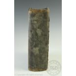
WELSH BIBLE: Bibl sanctaidd sef yr hen destament a'r Newydd, with two folding engraved maps,
WELSH BIBLE: Bibl sanctaidd sef yr hen destament a'r Newydd, with two folding engraved maps, Caerfyddin, 1770 (1) (at fault)

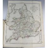
BARTHOLOMEW (J), THE IMPERIAL MAP OF ENGLAND AND WALES, according to the ordnance survey, fifteen maps / sheets including title and three smaller ...
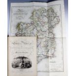
LEWIS (S), LEWIS'S ATLAS COMPRISING THE COUNTIES OF IRELAND, with large folding map of Ireland (small tear to left) and thirty two maps, all with ...
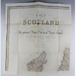
LEWIS (S), A TOPOGRAPHICAL DICTIONARY OF SCOTLAND, an atlas, six large folding maps, London,
LEWIS (S), A TOPOGRAPHICAL DICTIONARY OF SCOTLAND, an atlas, six large folding maps, London, 1846 (at fault)
LEWIS (S), ATLAS TO THE TOPOGRAPHOCAL DICTIONARIES OF ENGLAND AND WALES, comprising large folding map (torn), and fifty five country maps, all wit...