Refine your search
Filtered by:
- Sale Section
- List
- Grid
A subscription to the Price Guide is required to view results for auctions ten days or older. Click here for more information
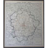

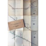
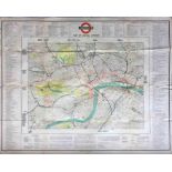
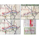
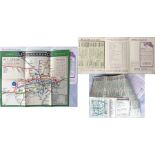
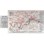
1930s London Transport MAP 'London Traffic Areas' with the London Passenger Traffic, London Traffic and Metropolitan Areas and Metropolitan Police...
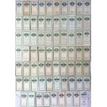
Large quantity (69) of London Transport POCKET MAPS for Country Buses 1948-69 and Green Line Coaches
Large quantity (69) of London Transport POCKET MAPS for Country Buses 1948-69 and Green Line Coaches 1947-70. Little if any duplication noted and ...
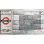
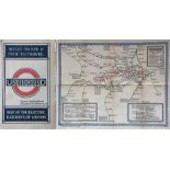
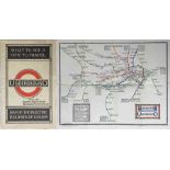
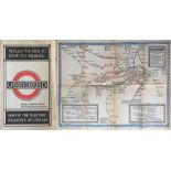
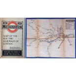
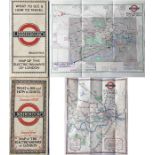
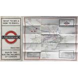
1924 London Underground POCKET MAP of the Electric Railways of London "What to see and how to travel". June 1924 edition. Map by J C Betts. Shows ...
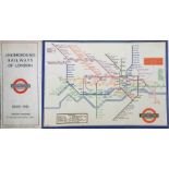
1933 London Underground H C Beck diagrammatic, card POCKET MAP from the first-year series titled '
1933 London Underground H C Beck diagrammatic, card POCKET MAP from the first-year series titled 'Underground Railways of London'. This is the edi...
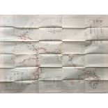
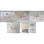
Set of 3 x 1938 London Underground CHARTS 'Initial Train Services, Distances and Running Times on
Set of 3 x 1938 London Underground CHARTS 'Initial Train Services, Distances and Running Times on Extension Lines - Metropolitan & Bakerloo, North...
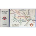
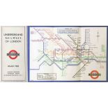
WW2 London Underground diagrammatic, card POCKET MAP by H C Beck. Issue No 1, 1945 (245). A very
WW2 London Underground diagrammatic, card POCKET MAP by H C Beck. Issue No 1, 1945 (245). A very good example, crisp and firm. [1]
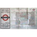
1924/5 London Underground POCKET MAP of the Electric Railways of London "What to see and how to
1924/5 London Underground POCKET MAP of the Electric Railways of London "What to see and how to travel". Winter 1924/25 (November 1924) edition. I...
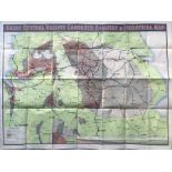
c1910-15 Great Central Railway COLLIERY & INDUSTRIAL MAP (paper). Shows agricultural land, manufacturing areas, proved & concealed coalfields and ...
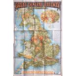
c1910-15 'Great Central Railway and its Connections' MAP (paper) with an inset enlarged scale map of
c1910-15 'Great Central Railway and its Connections' MAP (paper) with an inset enlarged scale map of central England. Strong, vibrant colours make...
1921 London Underground MAP OF THE ELECTRIC RAILWAYS OF LONDON 'What to See & How to Travel' with
1921 London Underground MAP OF THE ELECTRIC RAILWAYS OF LONDON 'What to See & How to Travel' with issue date 9-3-21. Designed by MacDonald Gill w...
1933 London Underground H C Beck diagrammatic, card POCKET MAP from the first-year series titled '
1933 London Underground H C Beck diagrammatic, card POCKET MAP from the first-year series titled 'Underground Railways of London'. Issued c.Septem...
c1925/26 'Stingemore' London Underground MAP (unusual paper issue) with 'Connections with Main
c1925/26 'Stingemore' London Underground MAP (unusual paper issue) with 'Connections with Main Line Termini' on the reverse. Inserted loose into t...
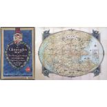
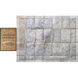
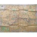
1930 MAP 'The Gleneagles Map' of the Heart of Scotland shewing 5,000 square miles of the Highlands &
1930 MAP 'The Gleneagles Map' of the Heart of Scotland shewing 5,000 square miles of the Highlands & Lowlands around Gleneagles Hotel'. Believed t...
Selection (10) of 1930s/40s London Underground diagrammatic card maps by Beck and Schleger comprising No 2 1934, No 1 1936, No 1 1937, No 1 1938, ...
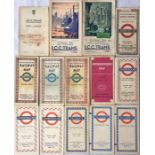
Selection (14) of 1920s-50s London Tramways & Underground POCKET MAPS in varying condition from
Selection (14) of 1920s-50s London Tramways & Underground POCKET MAPS in varying condition from well-used to very good. [14] ...[more]
Quantity (58) of London Transport etc POCKET MAPS from the 1920s-70s for Tramways, Trams & Trolleybuses, Country Buses and Green Line Coaches plus...
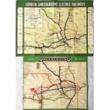
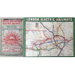
Pair of c1907/08 London Underground MAPS, single-sided, one from 1907, 17" x 12" (43cm x 31cm),
Pair of c1907/08 London Underground MAPS, single-sided, one from 1907, 17" x 12" (43cm x 31cm), the first to show the Charing Cross, Euston & Hamp...
1937 fold-out MAP of the 'Empire Air Scheme & other Commonwealth Air Routes in the Eastern Hemisphere, existing & projected. Covers Europe, Middle...
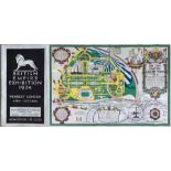
1924 British Empire Exhibition at Wembley official fold-out PLAN & MAP designed by Kennedy North
1924 British Empire Exhibition at Wembley official fold-out PLAN & MAP designed by Kennedy North in a style similar to MacDonald Gill with an Unde...
1922 London Underground MAP OF THE ELECTRIC RAILWAYS OF LONDON 'What to See & How to Travel' with
1922 London Underground MAP OF THE ELECTRIC RAILWAYS OF LONDON 'What to See & How to Travel' with issue date 1-3-22. Designed by MacDonald Gill w...
1921 London Underground MAP OF THE ELECTRIC RAILWAYS OF LONDON 'What to See & How to Travel' with
1921 London Underground MAP OF THE ELECTRIC RAILWAYS OF LONDON 'What to See & How to Travel' with issue date 9-3-21. Designed by MacDonald Gill w...
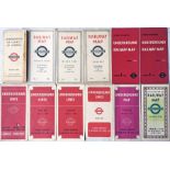
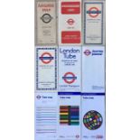
Selection (3) of 1960s special issues of the London Underground POCKET MAP comprising a card issue
Selection (3) of 1960s special issues of the London Underground POCKET MAP comprising a card issue for Freshwater Flats (mid-1960s Garbutt issue),...
Selection (3) of very early MAPS of proposed railways: c1845 Wolverhampton, Chester & Birkenhead
Selection (3) of very early MAPS of proposed railways: c1845 Wolverhampton, Chester & Birkenhead Junction Railway, c1845 Tunbridge Wells & Eastbou...
Selection of District Railway (London Underground) "Miniature MAPS of London & Environs" comprising 6th edition (c1904), 8th edition (c1907), 9th ...
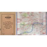
1926 London Underground 'Guide to Underground Travel' POCKET BOOKLET with card cover 'To and From
1926 London Underground 'Guide to Underground Travel' POCKET BOOKLET with card cover 'To and From Tooting Broadway, Trinity Road (Tooting Bec), Ba...
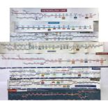
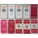
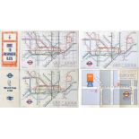
Selection (8) of London Underground CAR LINE DIAGRAMS for various lines, laminated and vinyl
Selection (8) of London Underground CAR LINE DIAGRAMS for various lines, laminated and vinyl versions. None are dated but appear to be from the 19...
Quantity of London Underground, mainly pocket, MAPS from the 1930s-1970s, including Beck issues, a
Quantity of London Underground, mainly pocket, MAPS from the 1930s-1970s, including Beck issues, a Stingemore and others. Plus a 1906 issue of the...
c. mid-1860s 'Excursionist's MAP of the Environs of London' published by George Philip & Son. On
c. mid-1860s 'Excursionist's MAP of the Environs of London' published by George Philip & Son. On paper inside board covers. Some colour, shows rai...
Pair of c1908 London Underground MAPS, the first types to show a unified system, one produced for
Pair of c1908 London Underground MAPS, the first types to show a unified system, one produced for the Central London Railway with their informatio...
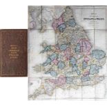
1848 Bett's Road & Railroad MAP of England & Wales. Linen-backed inside cloth-covered board covers
1848 Bett's Road & Railroad MAP of England & Wales. Linen-backed inside cloth-covered board covers with gold-leaf titling. Contemporary colouring ...
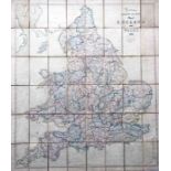
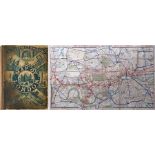
1860 Stanford's Railway & Road MAP of England & Wales. Linen-backed, in colour and opens out to
1860 Stanford's Railway & Road MAP of England & Wales. Linen-backed, in colour and opens out to 33" x 38" (84cm x 97cm). Well-used but intact and ...
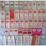
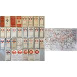
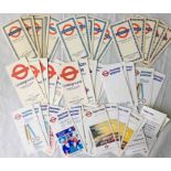
Quantity (38) of London General Omnibus & London Transport Central Buses POCKET MAPS dated from 1919
Quantity (38) of London General Omnibus & London Transport Central Buses POCKET MAPS dated from 1919 to 1974 plus a quantity (17) of AMENDMENT LEA...
1919 London Underground MAP OF THE ELECTRIC RAILWAYS OF LONDON 'What to See & How to Travel' with
1919 London Underground MAP OF THE ELECTRIC RAILWAYS OF LONDON 'What to See & How to Travel' with print-code 395-500M-2-10-19. Has the red bullsey...
Selection (10) of 1930s/40s London Underground diagrammatic card maps by Beck and Schleger comprising 34-1945.350M (very poor, separated), No 1 19...
1908 London Underground POCKET MAP issued by the Central London Railway with their own content on
1908 London Underground POCKET MAP issued by the Central London Railway with their own content on the reverse but using the standard London Electr...
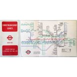
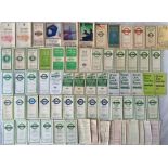
Quantity (c50) of London Underground diagrammatic card maps dated from 1955 to 2000 including issues
Quantity (c50) of London Underground diagrammatic card maps dated from 1955 to 2000 including issues by Beck, Hutchison and Garbutt. A few are in ...
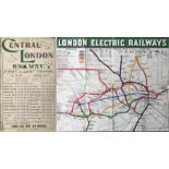
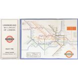
1929 London Underground quad-royal POSTER MAP 'Map of Central London' with the lines superimposed on
1929 London Underground quad-royal POSTER MAP 'Map of Central London' with the lines superimposed on a street map and listing places of interest a...
London Underground quad-royal POSTER MAP designed by Paul Garbutt. Undated but shows the original
London Underground quad-royal POSTER MAP designed by Paul Garbutt. Undated but shows the original Jubilee Line to Charing Cross and the Piccadilly...
1933 London Underground quad-royal POSTER MAP 'Underground Map of London'. Shows the lines superimposed on a street-map with stations depicted wit...
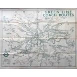
1936 London Transport quad-royal POSTER MAP 'Green Line Coach Routes'. A wonderful map showing the
1936 London Transport quad-royal POSTER MAP 'Green Line Coach Routes'. A wonderful map showing the pre-war coach network in its heyday and using t...
1929 London General Omnibus Co Ltd POSTER MAP showing 'roads served by Motor-Buses' and featuring
1929 London General Omnibus Co Ltd POSTER MAP showing 'roads served by Motor-Buses' and featuring the Underground Group 'bullseye' logo. Measures ...
Selection (4) of 1930s London Underground sheet/poster MAPS comprising early 30s quad-royal poster (poor condition, fragile) and 3 x c1937 sheet m...
Pair of 1920s London Underground POCKET MAPS comprising June 1924 edition by J C Betts, showing
Pair of 1920s London Underground POCKET MAPS comprising June 1924 edition by J C Betts, showing the British Empire Exhibition stations, a special ...
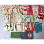
Large quantity (90+) of London Transport POCKET MAPS from the 1930s-70s including tram & trolleybus,
Large quantity (90+) of London Transport POCKET MAPS from the 1930s-70s including tram & trolleybus, central bus, country bus, Green Line etc. Gen...
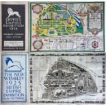
1924/25 British Empire Exhibition at Wembley items comprising the official 1924 fold-out PLAN &
1924/25 British Empire Exhibition at Wembley items comprising the official 1924 fold-out PLAN & MAP designed by Kennedy North in a style similar t...

Very large quantity (160+) of 1950s-70s London Transport etc POCKET MAPS of Central Buses, Country
Very large quantity (160+) of 1950s-70s London Transport etc POCKET MAPS of Central Buses, Country Buses, Green Line Coaches, 'London' & tourist i...
Selection of c1908 London Underground MAPS, the first types to show a unified system, one produced
Selection of c1908 London Underground MAPS, the first types to show a unified system, one produced for the Central London Railway with their infor...
c1902 Central London Railway fold-out POCKET MAP produced to promote its service from Bank to
c1902 Central London Railway fold-out POCKET MAP produced to promote its service from Bank to Shepherds Bush. The line is superimposed in red on a...
1933 London Underground H C Beck diagrammatic, card POCKET MAP from the first-year series titled '
1933 London Underground H C Beck diagrammatic, card POCKET MAP from the first-year series titled 'Underground Railways of London'. This is the edi...
1909 London Underground POCKET MAP. An unusual version produced for F Leach, Jewellers & Opticians
1909 London Underground POCKET MAP. An unusual version produced for F Leach, Jewellers & Opticians of Kilburn with their location and advertiseme...
1892 District Railway MAP OF LONDON, 5th edition. This is the first variant showing Barnsbury Sta on
1892 District Railway MAP OF LONDON, 5th edition. This is the first variant showing Barnsbury Sta on the North London line and the Regent's Canal,...
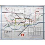
Selection (9) of London Underground diagrammatic card POCKET MAPS, one for each decade from the
Selection (9) of London Underground diagrammatic card POCKET MAPS, one for each decade from the 1930s-2010s. Selection comprises No 1 1937 (well u...
1933 London Underground H C Beck diagrammatic, card POCKET MAP from the first-year series titled '
1933 London Underground H C Beck diagrammatic, card POCKET MAP from the first-year series titled 'Underground Railways of London'. Issued c.Septem...
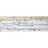
Selection (3) of 1960s London Underground CAR LINE DIAGRAMS comprising Bakerloo Line dated March
Selection (3) of 1960s London Underground CAR LINE DIAGRAMS comprising Bakerloo Line dated March 1965, Northern Line dated February 1967 and Picca...
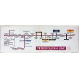
1957 London Underground Metropolitan Line card CARRIAGE MAP (LINE DIAGRAM) dated January 1957. These
1957 London Underground Metropolitan Line card CARRIAGE MAP (LINE DIAGRAM) dated January 1957. These diagrams were located in the compartments of ...
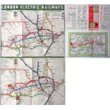
c1908 London Underground POCKET MAP 'London Electric Railways' with the short-lived 'Swift and Sure'
c1908 London Underground POCKET MAP 'London Electric Railways' with the short-lived 'Swift and Sure' sunburst design on the cover. Opens out to 14...
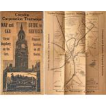
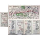
Croydon Corporation Tramways MAP & GUIDE TO CAR SERVICES dated February 1924. Printed on light-brown
Croydon Corporation Tramways MAP & GUIDE TO CAR SERVICES dated February 1924. Printed on light-brown paper with a cover picture of Croydon Town Ha...
1880 District Railway pocket MAP. Opens out to 18" x 11.5" (46" x 29") and can be dated by the
1880 District Railway pocket MAP. Opens out to 18" x 11.5" (46" x 29") and can be dated by the opening of the Putney Bridge (Fulham) extension. Sh...
1933 London Underground H C Beck diagrammatic, card POCKET MAP from the first-year series titled '
1933 London Underground H C Beck diagrammatic, card POCKET MAP from the first-year series titled 'Underground Railways of London'. Issued c.Decemb...
1923 London Underground MAP of the Electric Railways of London "What to see and how to travel".
1923 London Underground MAP of the Electric Railways of London "What to see and how to travel". Designed by MacDonald Gill with his distinctive st...