Filtered by:
- Category,
- Creator / Brand
- List
- Grid
This auctioneer has chosen to not publish their results. Please contact them directly for any enquiries.
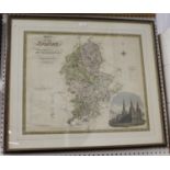

Josiah Neele, after Christopher and John Greenwood - 'Map of the County of Stafford', 19th century
Josiah Neele, after Christopher and John Greenwood - 'Map of the County of Stafford', 19th century engraving with near period hand-colouring, 58.5...
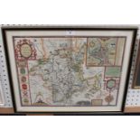
John Speed - 'Worcestershire Described' (Map of the County), 17th century engraving with later
John Speed - 'Worcestershire Described' (Map of the County), 17th century engraving with later hand-colouring, published by Sudbury and Humble, 38...
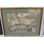
Christopher Saxton - 'Cantii, Southsexiae, Surriae et Middelsexiae comitat' (Map of South East
Christopher Saxton - 'Cantii, Southsexiae, Surriae et Middelsexiae comitat' (Map of South East England), 16th century engraving with later hand-co...
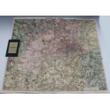
W.H. Smith (publisher) - 'Map of Environs of London', early 20th century lithograph, backed onto
W.H. Smith (publisher) - 'Map of Environs of London', early 20th century lithograph, backed onto linen, overall 74cm x 86.5cm, folding within clot...
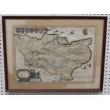
Willem & Jan Blaeu - 'Cantium Vernacule Kent' (Map of the County), 17th century engraving with later
Willem & Jan Blaeu - 'Cantium Vernacule Kent' (Map of the County), 17th century engraving with later hand-colouring on laid paper, 39cm x 54cm, to...
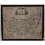
Richard Blome - 'A Mapp of the County of Suffolk', early 18th Century engraving with later hand-
Richard Blome - 'A Mapp of the County of Suffolk', early 18th Century engraving with later hand-colouring, 27cm x 32.5cm, within a Hogarth style f...