Refine your search
Sale Section
- Antiques, Art Reference and Architecture (15)
- Books (2)
- British Topography and Local History (34)
- Foreign Travel and Mountaineering (18)
- Literature (45)
- Maps and Atlases (68)
- Miscellaneous Items (1)
- Music (2)
- Natural History (35)
- Original Artwork, Children's and Illustrated (22)
- Religion (12)
- Sport (8)
Estimate
Category
Filtered by:
- Item Type
- List
- Grid
A subscription to the Price Guide is required to view results for auctions ten days or older. Click here for more information


Thoresby, Ralph; Whitaker, Thomas Dunham Ducatus Leodiensis. R. Dewhirst, 1816; Loidis and Elmete.
Thoresby, Ralph; Whitaker, Thomas Dunham Ducatus Leodiensis. R. Dewhirst, 1816; Loidis and Elmete. T. Davison, 1816. Folio (2 vols). Full calf, so...
Poulson, George The History and Antiquities of the Seigniory of Holderness. Hull: Robert Brown, 48
Poulson, George The History and Antiquities of the Seigniory of Holderness. Hull: Robert Brown, 48 Lowgate; and W. Pickering, London, 1840-1. 4to ...

Banks, W. Views in the Lakes. c.1860s. 8vo, full green calf gilt by J. Coats & Son, Leeds, spine
Banks, W. Views in the Lakes. c.1860s. 8vo, full green calf gilt by J. Coats & Son, Leeds, spine with contrasting morocco lettering-piece, watered...

Farren, Robert Drawn and Etched. 4to, half calf; 30 plates (25 signed by Farren), dated variously
Farren, Robert Drawn and Etched. 4to, half calf; 30 plates (25 signed by Farren), dated variously c.1879-1886. Farren was born in Cambridge, and b...

Macculloch, John The Highlands and Western Isles of Scotland. Longman, Rees et al, 1824. 8vo (4 vols
Macculloch, John The Highlands and Western Isles of Scotland. Longman, Rees et al, 1824. 8vo (4 vols in 2). Leather-backed marbled boards, sometim...
![Scott, Walter (intro.) Border Antiquities. Longmans & Co., [c.1815]. 4to (2 vols). Half red morocco;](https://portal-images.azureedge.net/auctions-2019/srten10655/images/984958eb-6bf2-47b4-915b-aac500944a59.jpg?w=155&h=155)
Scott, Walter (intro.) Border Antiquities. Longmans & Co., [c.1815]. 4to (2 vols). Half red morocco;
Scott, Walter (intro.) Border Antiquities. Longmans & Co., [c.1815]. 4to (2 vols). Half red morocco; eng. frontis. and tit. in both, 93 plates acr...

Cotes, V. Cecil Two Girls on a Barge. Chatto & Windus, 1891. 8vo, org. pictorial cloth; forty-four
Cotes, V. Cecil Two Girls on a Barge. Chatto & Windus, 1891. 8vo, org. pictorial cloth; forty-four illus by F.H. Townshend. First ed. V. Cecil Cot...

Dashwood, J.B. The Thames to the Solent by Canal and Sea, or the Log of the Una Boat 'Caprice'.
Dashwood, J.B. The Thames to the Solent by Canal and Sea, or the Log of the Una Boat 'Caprice'. Longmans, Green, & Co., 1868. 8vo, org. purple clo...
De Salis, Henry Rodolph Bradshaw's Canals and Navigable Rivers of England and Wales. A Handbook of
De Salis, Henry RodolphBradshaw's Canals and Navigable Rivers of England and Wales. A Handbook of Inland Navigation. Henry Blacklock & Co., 1904. ...

British Inland Waterways A collection of works on and relating to the inland waterways of Britain.
British Inland Waterways A collection of works on and relating to the inland waterways of Britain. These include on uses and problems of canals, n...

Love, John Geodaesia: or, the Art of Surveying and measuring of Land Made Easie. Printed for John
Love, John Geodaesia: or, the Art of Surveying and measuring of Land Made Easie. Printed for John Taylor, at the Ship in S. Paul's Church-Yard, 16...
Roxburghe Club; Rotz, Jean The Maps and Text of the Boke of Idrography Presented by Jean Rotz to
Roxburghe Club; Rotz, Jean The Maps and Text of the Boke of Idrography Presented by Jean Rotz to Henry VIII. Edited by Helen Wallis with a forewor...
Mela, Pomponius Pomponii Melae de Situ Orbis Libri Tres...Opera et Studio Joannis Reinoldi. Eton: T.
Mela, Pomponius Pomponii Melae de Situ Orbis Libri Tres...Opera et Studio Joannis Reinoldi. Eton: T. Pote, 1789. 8vo, leather-backed boards (board...
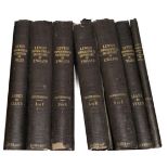
Lewis, Samuel Topographical Dictionary of England and Wales. S. Lewis & Co., 1848. 4to (7 vols).
Lewis, Samuel Topographical Dictionary of England and Wales. S. Lewis & Co., 1848. 4to (7 vols). Org. cloth; 58 maps, hand coloured in outline, in...
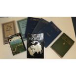
20th Century Atlases Bartholomew, John (ed.) The Times Atlas of the World. Mid-Century edition.
20th Century Atlases Bartholomew, John (ed.) The Times Atlas of the World. Mid-Century edition. 1955-59. Folio (5 vols). Org. cloth, two in djs. P...
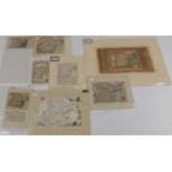
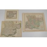
Essex Eight maps of Essex, dating from c.1673-c.1830, all hand-coloured, four mounted. The maps
Essex Eight maps of Essex, dating from c.1673-c.1830, all hand-coloured, four mounted. The maps range from Richard Blome's plagarising ''Hundreds ...
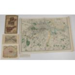
London Four London maps comprising: Plans of Baynards Castle and Faringdon Wards and Candlewick
London Four London maps comprising: Plans of Baynards Castle and Faringdon Wards and Candlewick and Langborn Wards, 1784. Two hand-coloured plans ...
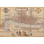
Braun, Georg; Hogenberg, Franz Londinum feracissimi Angliae Regni metropolis. First published in
Braun, Georg; Hogenberg, FranzLondinum feracissimi Angliae Regni metropolis. First published in Civitates Orbis Terrarum, c.1570. Hand-coloured. L...
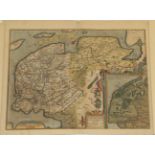
Ortelius, Abraham Frisia Occidentalis. Depicted by Sibrandus Leo of Leeuwarden, 1579 [but likely c.
Ortelius, Abraham Frisia Occidentalis. Depicted by Sibrandus Leo of Leeuwarden, 1579 [but likely c.1608, vide infra]. Hand-coloured in wash, Itali...
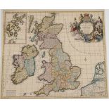
Allard, Carolus Regnorum Magnae Britanniae sive Angliae Scotiae, nec non Hiberniae. Amsterdam, c.
Allard, Carolus Regnorum Magnae Britanniae sive Angliae Scotiae, nec non Hiberniae. Amsterdam, c.1695. Hand-coloured, decorative cartouche, inset ...
Bill, John Five maps, being: Buckinghamshire; Barkeshire; Notinghamshire; Hartfordshire; and Essex. 1626. Three mounted, others loose, English tex...
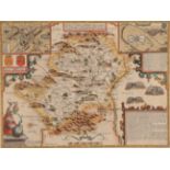
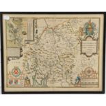
![Bill, John Suffolk; and Cambridgeshire and Isle of Ely. 1626. Framed and glazed. [2]](https://portal-images.azureedge.net/auctions-2019/srten10655/images/d5adcd71-682f-4062-893a-aab700ddda72.jpg?w=155&h=155)
Bill, John Suffolk; and Cambridgeshire and Isle of Ely. 1626. Framed and glazed. [2] ...[more]
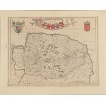
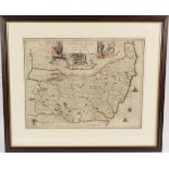
Blaeu, Joan Nortfolcia or Norfolke. Amsterdam: Blaeu, 1645. Hand-coloured, armorial cartouche, title
Blaeu, Joan Nortfolcia or Norfolke. Amsterdam: Blaeu, 1645. Hand-coloured, armorial cartouche, title decorated with arms of principal Peers of the...
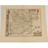
Blaeu, Joan Essex Comitatus. 17th c. or later. Hand-coloured. After Blaeu's death, and the closing
Blaeu, Joan Essex Comitatus. 17th c. or later. Hand-coloured. After Blaeu's death, and the closing of his firm, the plates were purchased by G. Va...
Blaeu, Johannes Plan de la Ville et des Environs de Pavie. Amsterdam: Pieter Mortier, 1704. Engraved
Blaeu, Johannes Plan de la Ville et des Environs de Pavie. Amsterdam: Pieter Mortier, 1704. Engraved map, uncoloured, framed and glazed. Blaeu ori...
Camden, William Camden's Britannia. Times Newspapers Limited, 1971. Folio, org. cloth-backed boards,
Camden, William Camden's Britannia. Times Newspapers Limited, 1971. Folio, org. cloth-backed boards, spine decorated in silver; port., maps and ot...
Drayton, Michael; Hole, William (eng.) Oxford, Bucks and Berks. 1612. Hand-coloured, mounted.
Drayton, Michael; Hole, William (eng.) Oxford, Bucks and Berks. 1612. Hand-coloured, mounted. Drayton was an Elizabethan poet and friend to Shakes...
Drayton, Michael; Hole, William (eng.) Surrey and Sussex. 1612. Hand-coloured, mounted. ...[more]
Drayton, Michael; Hole, William (eng.) Yorkshyre. 1622. Hand-coloured, framed and glazed. Yorkshire was first published in the second part of Poly...
Janssonius, Johannes Essexiae Descriptio. Amsterdam: Johannes Janssonius, 1659. Hand-coloured.
Janssonius, Johannes Essexiae Descriptio. Amsterdam: Johannes Janssonius, 1659. Hand-coloured. ...[more]
Jansson, J. Norfolciae Descriptio. Amsterdam, c.1636. Early hand-colouring in wash, framed and
Jansson, J. Norfolciae Descriptio. Amsterdam, c.1636. Early hand-colouring in wash, framed and glazed. Early issue, though the map is framed singl...
Jansson, J. Suffolciae Nova et Accurate Delineatio. c.1644. Later hand-colouring, framed and glazed.
Jansson, J. Suffolciae Nova et Accurate Delineatio. c.1644. Later hand-colouring, framed and glazed. Pre-atlas issue, without later coats-of-arms....
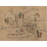
Ogilby, John Three strip road maps comprising London to Bristol and the Continuation of the same;
Ogilby, John Three strip road maps comprising London to Bristol and the Continuation of the same; and London to Harwich. From Britannia, c.1675. H...
Yorkshire Road Maps Ogilby, John. The continuation of the extended Road from Oakeham in Rutland to
Yorkshire Road Maps Ogilby, John. The continuation of the extended Road from Oakeham in Rutland to Richmond. 1675. Framed and glazed. With Owen an...
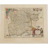
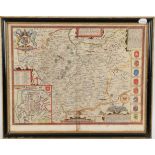
![Saxton, Christopher; Hole, William (eng.) West Riding and North Riding. [1610]. Framed and glazed.](https://portal-images.azureedge.net/auctions-2019/srten10655/images/d886a0b8-77c0-44cc-9304-aab700dde450.jpg?w=155&h=155)
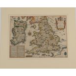
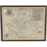
Saxton, Christopher; Hole, William (eng.) West Riding and North Riding. [1610]. Framed and glazed.
Saxton, Christopher; Hole, William (eng.) West Riding and North Riding. [1610]. Framed and glazed. From Camden's Britannia. The maps have no text ...
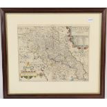
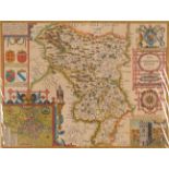
Saxton, Christopher; Kip, William Northamtoniae Comitatus descriptio in quo coritani olim insederunt. c.1637. Hand-coloured, framed and glazed. ....
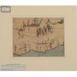
Speede, John The Invasions of England and Ireland and al their Ciuill Wars Since the Conquest.
Speede, John The Invasions of England and Ireland and al their Ciuill Wars Since the Conquest. George Humble, c.1627 or later. Hand-coloured and m...
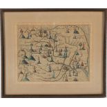
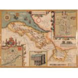
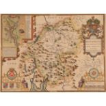
![Speede, John; More, John Canaan. Thomas Basset and Richard Chiswell, 1651 [1676]. Framed and](https://portal-images.azureedge.net/auctions-2019/srten10655/images/0a060264-c139-4285-8ec1-aab700dde6a5.jpg?w=155&h=155)
Speede, John; More, John Canaan. Thomas Basset and Richard Chiswell, 1651 [1676]. Framed and glazed double-sided, hand-coloured, English text on v...
Speede, John Cambridgeshire described. John Sudbury and George Humble, c.1610. Framed and glazed
Speede, John Cambridgeshire described. John Sudbury and George Humble, c.1610. Framed and glazed double-sided, hand-coloured both sides, English t...
Speede, John Darbieshire described. John Sudbury and George Humble, c.1610. Modern hand-coloured and
Speede, John Darbieshire described. John Sudbury and George Humble, c.1610. Modern hand-coloured and mounted. ...[more]
Speede, John The Bishoprick and Citie of Durham. Thomas Bassett and Chiswell, 1676. Hand-coloured,
Speede, John The Bishoprick and Citie of Durham. Thomas Bassett and Chiswell, 1676. Hand-coloured, framed and glazed double-sided.
Speede, John; Norden, John Essex, divided into Hundreds. George Humble, c.1610. Hand-coloured.
Speede, John; Norden, John Essex, divided into Hundreds. George Humble, c.1610. Hand-coloured. ...[more]
Speede, John Flintshire. John Sudbury and George Humble, c.1610. Modern hand-coloured and mounted.
Speede, John Flintshire. John Sudbury and George Humble, c.1610. Modern hand-coloured and mounted. ...[more]
Speede, John Hartfordshire Described. John Sudbury and George Humble, c.1610. Hand-coloured.
Speede, John Hartfordshire Described. John Sudbury and George Humble, c.1610. Hand-coloured. ...[more]
Speede, John Leicester. John Sudbury and George Humble, c.1610. Framed and glazed double-sided,
Speede, John Leicester. John Sudbury and George Humble, c.1610. Framed and glazed double-sided, hand-coloured, English text on verso. ...[more]
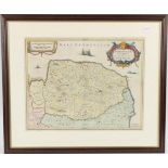
Saxton, Christopher; Speede, John Norfolk A Countie Florishing & Populous. John Subdbury and
Saxton, Christopher; Speede, John Norfolk A Countie Florishing & Populous. John Subdbury and George Humble, c.1610. Hand-coloured and mounted. .....
Speede, John The Countie Westmorland and Kendale the Chief Towne Described. George Humble, c.1610.
Speede, John The Countie Westmorland and Kendale the Chief Towne Described. George Humble, c.1610. Hand-coloured and mounted. ...[more]
Speede, John The Countie of Westmorland and Kendale the Cheif Towne described. George Humble, c.
Speede, John The Countie of Westmorland and Kendale the Cheif Towne described. George Humble, c.1610. Framed and glazed double-sided, hand-coloure...
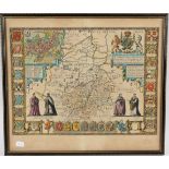
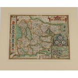
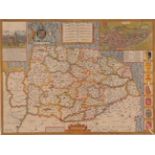
![Speede, John Yorkshire. To be solde by Roger Rea the Elder and Younger, [c.1662]. Framed and](https://portal-images.azureedge.net/auctions-2019/srten10655/images/b84b8c91-38a1-40c0-ac3b-aab700ddefe8.jpg?w=155&h=155)
Speede, John Yorkshire. To be solde by Roger Rea the Elder and Younger, [c.1662]. Framed and
Speede, John Yorkshire. To be solde by Roger Rea the Elder and Younger, [c.1662]. Framed and glazed both sides, hand-coloured, English text on ver...
Speede, John; Arlott, John (ed.) John Speed's England. A coloured facsimile of the first edition.
Speede, John; Arlott, John (ed.) John Speed's England. A coloured facsimile of the first edition. Phoenix House Limited, 1953. Folio (4 vols). Hal...
Bickham, George the Younger Five maps from a series of county maps comprising: Leicestershire;
Bickham, George the Younger Five maps from a series of county maps comprising: Leicestershire; Bedfordshire; Kent; Middlesex; and Essex, c.1752. H...
![Bodenehr, Gabriel Londen, Westmunster U Soudwark. Augsburg, [c.1710]. Uncoloured, two sheets](https://portal-images.azureedge.net/auctions-2019/srten10655/images/6ba4cdcd-b6c7-48c7-8ddd-aab700ddf1d8.jpg?w=155&h=155)
Bodenehr, Gabriel Londen, Westmunster U Soudwark. Augsburg, [c.1710]. Uncoloured, two sheets
Bodenehr, Gabriel Londen, Westmunster U Soudwark. Augsburg, [c.1710]. Uncoloured, two sheets joined as one, German text flanking map and extensive...
Bowen, Emmanuel The Accurate Map of the County of Essex. Printed for J. Beale, c.1750. ...[more]
Bowles, Carington New Pocket Map of the County of Essex. Carington Bowles, 1781. Hand-coloured.
Bowles, Carington New Pocket Map of the County of Essex. Carington Bowles, 1781. Hand-coloured. ...[more]
Cary, John Essex, 1787. Hand-coloured and mounted. With A New Map of Essex Divided Into Hundreds,
Cary, John Essex, 1787. Hand-coloured and mounted. With A New Map of Essex Divided Into Hundreds, 1801. Hand-coloured. And A Map of Essex from the...
Chapman, John; Andre, Peter A Map of the County of Essex from an Actual Survey taken in MDCCLXXII,
Chapman, John; Andre, Peter A Map of the County of Essex from an Actual Survey taken in MDCCLXXII, LXXIII and MDCCLXXIV. Chelmsford, Chalk, Meggy ...
Châtelain Nouvelle Carte du Gouvernement Civil d'Angleterre et de Celuy de la Ville de Londres.
Châtelain Nouvelle Carte du Gouvernement Civil d'Angleterre et de Celuy de la Ville de Londres. Amsterdam, 1708. ...[more]
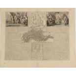
![Collins, Grenville Decorative frontispiece from Great Britains Coasting Pylot, [1693]. Hand-](https://portal-images.azureedge.net/auctions-2019/srten10655/images/cd3effb0-7530-467b-9bb3-aab700ddf653.jpg?w=155&h=155)
Collins, Grenville Decorative frontispiece from Great Britains Coasting Pylot, [1693]. Hand-
Collins, Grenville Decorative frontispiece from Great Britains Coasting Pylot, [1693]. Hand-coloured. ...[more]
![London A New and Correct Plan of London, Westminster and Southwark. R. & J. Dodsley, [1761].](https://portal-images.azureedge.net/auctions-2019/srten10655/images/23af1ae3-b0aa-46c4-bed2-aab700ddf6f1.jpg?w=155&h=155)
London A New and Correct Plan of London, Westminster and Southwark. R. & J. Dodsley, [1761].
London A New and Correct Plan of London, Westminster and Southwark. R. & J. Dodsley, [1761]. ...[more]
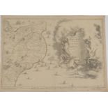
Fricx, Eugene Henry Decorative cartouche sheet from Cartes Des Provinces Des Pays Bas Contenant
Fricx, Eugene Henry Decorative cartouche sheet from Cartes Des Provinces Des Pays Bas Contenant les Comte´s de Flandre, de Hainaut, Cambresis, le ...