Refine your search
Filtered by:
- Category,
- Item Type
- List
- Grid
A subscription to the Price Guide is required to view results for auctions ten days or older. Click here for more information
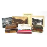

Collection of Hargrove's History of the castle, Town, and Forest of Knaresbrough, with Harrogate,
Collection of Hargrove's History of the castle, Town, and Forest of Knaresbrough, with Harrogate, and its Medicinal Waters. 2nd ed. (1775); 3rd ed...
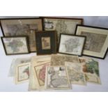
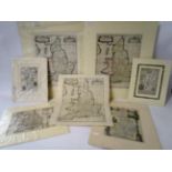
A collection of maps of Westmoreland including: Saxton likely the 1637 edition (with plate number in
A collection of maps of Westmoreland including: Saxton likely the 1637 edition (with plate number in lower left corner); Cary, John 1787. Archer, ...
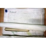
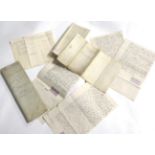
A schedule and maps bound together with ties with legal instruments relating to Gressingham Hall
A schedule and maps bound together with ties with legal instruments relating to Gressingham Hall Estate, c.1844, with a loose map of Gressingham H...
A map illustrating Storrs Hall in the county of Lancaster surveyed 1722, signed Thomas Buttle;
A map illustrating Storrs Hall in the county of Lancaster surveyed 1722, signed Thomas Buttle; together with a plan of an estate called Storrs Hal...
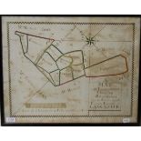
Hand-drawn map, hand-coloured in outline, of Tummoor Estate in Quarmoor, Lancaster, 1722, showing
Hand-drawn map, hand-coloured in outline, of Tummoor Estate in Quarmoor, Lancaster, 1722, showing estate and surrounding lands, framed and glazed
Maps including: Bowen, West Riding, 18thc; Owen and Bowen Three road ribbon maps showing Lancaster, Burton and Kendal. 18th c; Grose, Bedfordshire...
Bowen, three road ribbon maps, showing Ferrybridge, Wetherby and Rippon, c.1720; Badeslade, two
Bowen, three road ribbon maps, showing Ferrybridge, Wetherby and Rippon, c.1720; Badeslade, two small county maps of Derbyshire and Nottinghamshir...
Large Scale Ordnance Survey Maps, a quantity including Bishop Auckland/Shildon, 1859 (6 inch to
Large Scale Ordnance Survey Maps, a quantity including Bishop Auckland/Shildon, 1859 (6 inch to mile); Watermillock, 1899 (1/2500), etc. rolled sh...
A collection of maps, six mounted and one unmounted, including Sturt Britannia Saxonica, strips maps
A collection of maps, six mounted and one unmounted, including Sturt Britannia Saxonica, strips maps from Owen and Bowen, and Thomas Moule Cambrid...
Middlesbrough-Guisbrough Railway Map showing the land of Revd. James Park and the proposed line of
Middlesbrough-Guisbrough Railway Map showing the land of Revd. James Park and the proposed line of the railway, hand-drawn and hand-coloured in ou...

Scawton, North Yorkshire, a Bolckow archive. An archive of legal instruments relating to estates
Scawton, North Yorkshire, a Bolckow archive. An archive of legal instruments relating to estates in and around the Township of Scawton, principall...