Filtered by:
- Category
- List
- Grid
A subscription to the Price Guide is required to view results for auctions ten days or older. Click here for more information
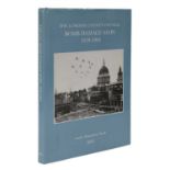

BOMB DAMAGE MAPS,
BOMB DAMAGE MAPS, 'The London County Council Bomb damage maps, 1939-1945', by Anne Saunders (ED), with an introduction by Robert Woolren, Topograp...

*ROWLAND EMETT OBE (1906-1990) Festival of Britain, 'EMETT RAILWAY, 'NELLIE', A STANDARD ENGINE' Blueprint with pencil corrections by the artist f...
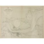
ADMIRALTY CHART OF THE RIVER THAMES, an early Admiralty chart of the River Thames, Broadness to Mucking Flats including Gravesend and Lower Hope R...
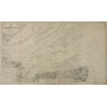
ADMIRALTY CHART OF THE RIVER THAMES, an early Admiralty chart of the River Thames Entrance, North Foreland to the Nore, from the latest Admiralty ...
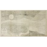
ADMIRALTY CHART OF THE RIVER THAMES, an early Admiralty chart of River Thames Sea Reach surveyed by The Port of London Authority to 1931, first pu...
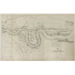
ADMIRALTY CHART OF THE RIVER THAMES, an early Admiralty chart of Erith to Broadness from surveys by the Port of London Authority to 1933, first pu...
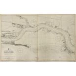
ADMIRALTY CHART OF THE RIVER THAMES, an early Admiralty chart of Woolwich to Erith from surveys by The Port of London Authority to 1931, first pub...
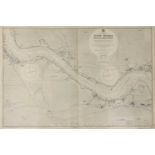
ADMIRALTY CHART OF THE RIVER THAMES, an early Admiralty chart of London Bridge to Woolwich including The Isle of Dogs (Canary Wharf) and Greenwich...
Buckingham Palace Map,
BUCKINGHAM PALACE MAP, a 1916 Land Registry Map of Buckingham Palace, Green Park, Belgravia, Mayfair, St James’s Park and St James and parts of We...
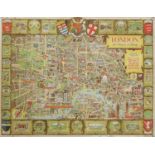
DUCKHAM'S MAP OF LONDON,
DUCKHAM'S MAP OF LONDON, 1950s/1960s, Duckham's Historical Map of the City of London, designed by L J Flux published by DUCKHAM OILS of West Wickh...
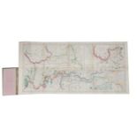
RIVER THAMES,
RIVER THAMES, 1- Bacon’s New Map of the River Thames, from its source to the sea. With descriptive notes. Being a guide for yachtsmen, oarsmen, an...
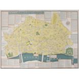
LONDON, THE BASTION OF LIBERTY,
LONDON, THE BASTION OF LIBERTY, designed by Kerry Lee in 1946, published by Pictorial Maps Limited, printed by Chromoworks Limited, 100.5 x 124.5c...
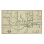
A LONDON UNDERGROUND MAP,
A LONDON UNDERGROUND MAP, 1957, HC Beck London Diagram of Lines Underground Map – LT Code 1156/2672D.1,000,000, 23 x 15cm
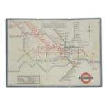
A LONDON UNDERGROUND MAP,
A LONDON UNDERGROUND MAP, 1947, HC Beck London Diagram of Lines Underground Map – LT Code 146.214G.250000 (2R) A rare post-WWII low circulation ma...
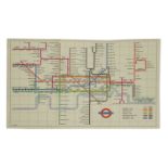
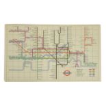
A LONDON UNDERGROUND MAP,
A LONDON UNDERGROUND MAP, 1960, HC Beck London Diagram of Lines Underground Map – LT Code 360/5952/500,000, 23 x 15cm This design of the London Un...
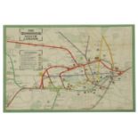
A LONDON UNDERGROUND MAP,
A LONDON UNDERGROUND MAP, 1933, a rare London Passenger Transport Board - Underground railways map of London 1933, designed by H C Beck, 2nd Editi...
A LONDON UNDERGROUND POCKET MAP,
A LONDON UNDERGROUND POCKET MAP, 1911, designed by F H Stingamore, printed by Johnson, Riddle & Co., paper backed, 27 x 20.5cm map size The map is...
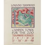
A LONDON TRAMWAY'S POSTER,
A LONDON TRAMWAY'S POSTER, 1925, 'CAMDEN TOWN FOR THE ZOO', designed by F W Farleigh, printed by Vincent Brook Day, linen backed, 76 x 51.5cm