Refine your search
Filtered by:
- Show only bulk lots,
- Category
- List
- Grid
A subscription to the Price Guide is required to view results for auctions ten days or older. Click here for more information

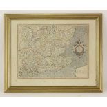
A 1610 map of Essex by John Norden and John Speed. Coloured. 40 x 52.5cm
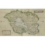
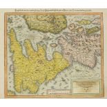
A rare engraved and coloured Map of Omi Province, Japan,1872, the land enclosing Lake Biwa and
A rare engraved and coloured Map of Omi Province, Japan, 1872, the land enclosing Lake Biwa and showing the hills, rivers and towns, coloured gree...
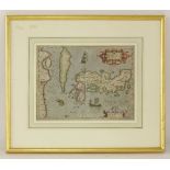
Jodocus Hondius Japonia 17th century hand coloured map, 35 x 45cm
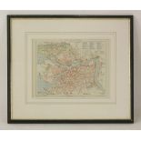
Geogr Brockhaus (publisher)St PetersburgEarly 20th century coloured map,30 x 25cm,Another map of
Geogr Brockhaus (publisher) St Petersburg Early 20th century coloured map, 30 x 25cm, Another map of St Petersberg and a map of Hertfordshire (3)
Sebastian Munster,British Isles (Hand-Coloured Map). Basle, nd, c1550. vg+/Fine42.5 x 33.5cm
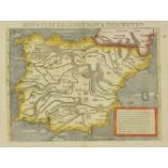
Sebastian Munster,Spain/Portugal (Hand-Coloured Map). Basle, 1550. vg40.5 x 30cm
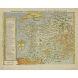
Sebastian Munster,1. France- Galliae regionis nova descripto (Hand-Coloured Map). Basle, c1550. vg;
Sebastian Munster,1. France- Galliae regionis nova descripto (Hand-Coloured Map). Basle, c1550. vg;39 x 32cm 2. PARIS- Paris die stat Parys. Bas...
Sebastian Munster,Sri Lanca. Uncoloured; Basle, 1542. vg+39.5 30.5cm
Sebastian Munster,British Isles. Uncoloured; Basle, 1540. With minor restoration32 x 42cm
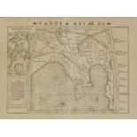
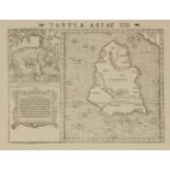
Sebastian Munster,South East Asia- Tabula Asiae XI. Uncoloured; Basle, 1542. vg32 x 42cm
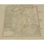
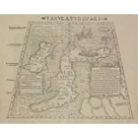
Sebastian Munster,France - Tabula Europae III. Uncoloured; Basle, 1540. vg+/fine39 x 31cm
1. STANFORD, Edward (Publisher); Toronto Lithographing Co. (Engraved & printed by): Canada: Nine
1. STANFORD, Edward (Publisher); Toronto Lithographing Co. (Engraved & printed by): Canada: Nine linen backed folding coloured Maps: British Col...
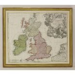
Johann Baptiste HomannA map of Great Britain'Magna Britannia complectens Angliae, Scotiae.......'
Johann Baptiste HomannA map of Great Britain'Magna Britannia complectens Angliae, Scotiae.......'172449 x 58cm
Mercator's map of South of England,Warwicum, Northamtonia, Huntingdonia, etc, from an atlas with
Mercator's map of South of England,Warwicum, Northamtonia, Huntingdonia, etc, from an atlas with French text verso,37 x 47cm
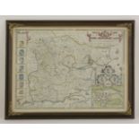
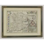
John Speede,Essex divided into hundreds, with the most ancient and fayre towne Colchester,Engraved
John Speede,Essex divided into hundreds, with the most ancient and fayre towne Colchester,Engraved map and hand coloured51 x 38.5cm, double glazed...
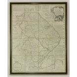
Emanuel Bowen,Lincolnshire divided into its wapontakes,18th century, hand coloured map,72.5 x 53cm
Emanuel Bowen,Lincolnshire divided into its wapontakes,18th century, hand coloured map,72.5 x 53cm
DE WIT, Frederick; Danckerts; & others: Composite Atlas, with 69 Double page Maps (one large folding); with over 42 by De Wit. Amsterdam, no date,...
MARTIN, R. Montgomery (editor): Tallis's Illustrated Atlas, and Modern History of the World, Geographical, Political, Commercial and Statistical....
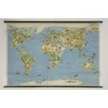
Two large coloured wall maps, PLUS a quantity of Ordinance Survey Maps. (qty.)