Refine your search
Filtered by:
- Primary Category
- List
- Grid
A subscription to the Price Guide is required to view results for auctions ten days or older. Click here for more information


SENEX, John: a New Map of City of London 1720. Hand coloured & framed. Stain to corners, (51 x 60cm). ...[more]

BOWEN, E:
BOWEN, E: An improved MAP of the County of Stafford divided into its hundreds. C1749, (69.5 x 51.5cm), hand coloured, mounted, framed & glazed. ....

UK MAPS (Hand coloured):
UK MAPS (Hand coloured): Speed, J: Devonshire with Excester Described. C1695 (50 x 37cm); Bleau: Hertfordshire. C1645 (49 x 37cm); Morden: Norfolk...

Greenville Collins, (Four hand coloured Maps, C1693): Cornwall & the Scilly Isles, (55 x 45cm); Holyhead & Anglesey, (55 x 42cm); Dartmouth, (57 x...

MAPS: OGilby, J:
MAPS: OGilby, J: The Road from Chelmsford in Essex to St. Edmonds-Bury in Suffolk & Saffron-Walden in Essex. (43 x 33cm), Hand coloured, mounted, ...

GREENWOOD: Essex. Map of the County of Essex, (75 x 65cm), from an Actual Survey made in the Year 1824. With a vignette view of Audley End House. ...

EIGHT MAPS OF HUNTINGDONSHIRE, Plus one other (mostly hand coloured & mounted, some framed & glazed, including: Bowen: An Accurate Map of The Coun...

MAPS: Jansson, Joan:
MAPS: Jansson, Joan: Comitatis Cantabrigiensis - vernacule Cambridgeshire. C1646; (52 x 40cm), hand coloured, mounted, framed & glazed; Plus: Blae...

MAPS: Blaeu, J: MAP OF CAMBRIDGESHIRE, CANTABRIGIENSIS COMITATUS, c1645; (52 x 40cm), Plus: Ogilby, J: The Road from Chelmsford in Essex to Maldon...

MAPS: MORDEN:
MAPS: MORDEN: Middlesex Olima Trinoban Tibus. (34 x 27cm), hand coloured, mounted, framed & glazed; CARY: Great Britain & Ireland, with Judges Cir...

Four MORDEN MAPS
Four MORDEN MAPS- All Hand-coloured, measuring approximately (34 x 40cm), mounted, framed & glazed: Kent; Devonshire; Gloucestershire; & Oxfordshi...

Four MORDEN MAPS, plus one
Four MORDEN MAPS, plus one- All hand-coloured, measuring approximately (34 x 40cm), mounted, framed & glazed: Lincolnshire; Huntingdonshire; Derb...

Four MORDEN MAPS
Four MORDEN MAPS- All Hand-coloured, measuring approximately (34 x 40cm), mounted, framed & glazed. Hertfordshire; Norfolk; Suffolk; & Middlesex; ...

Five MORDEN MAPS - The LAKES & Surrounding, All Hand-coloured, measuring approximately (34 x 40cm), mounted, framed & glazed: Northumberland; Durh...

MAPS/ MORDEN: 1- Warwickshire, c1695. Hand coloured, mounted, framed and glazed (42 X 360cm); 2- Northamptonshire, c1695. Hand coloured, mounted,...

MAP: SPEED, John:
MAP: SPEED, John: Cambridgshire described with the devision of the hundreds, the townes situation with the Armes of the Colleges of that famous Un...

MAPS: 4 sets of 18th. & 19th. Century Maps: Morden, Cary, Bowen, Kitchin, Etc. Worcestershire: 6 maps; Herefordshire: 6 maps; Staffordshire: 6 map...

Thomas Dix: New Map of the County of Hertfordshire Divided into Hundreds. William Darton & Son: C1833. Hand coloured, Mounted, framed & glazed.(37...

Two MORDEN MAPS
Two MORDEN MAPS- Both Hand-coloured, measuring approximately (34 x 40cm), mounted, framed & glazed: Smaller Islands of the British Ocean, c1695; &...

MAP: KEULEN, Johannes van:
MAP: KEULEN, Johannes van: Paskaert Van d'Oost Kust van Engelandt van Dover tot Dunwich.. (Double page chart of the coastline of southeast England...

Two Morden maps, both hand coloured, England, (36.5 x 42cm) and Buckinghamshire, (43 x 36cm), and
Two Morden maps, both hand coloured, England, (36.5 x 42cm) and Buckinghamshire, (43 x 36cm), and a smaller map, De L'Europe figure 11, (18.5 x 12...

Three MORDEN MAPS
Three MORDEN MAPS- Two hand-coloured, measuring approximately (34 x 40cm), mounted, framed & glazed: Monmouth; North Wales; & South Wales (not col...

Two MORDEN MAPS
Two MORDEN MAPS- Both hand-coloured, measuring approximately (34 x 40cm), mounted, framed & glazed: Britannia Romana; & Britannia Saxonica. (2) ...

MAP: BLAEU:
MAP: BLAEU: Magnae Britanniae et Hiberniae Tabula. C1695. (46 x 36cm), hand coloured, mounted, framed & glazed ...[more]

MAP- SAXTON/SPEED:
MAP- SAXTON/SPEED: The Kingdome of England augmented by John Speed. Flander, 1610, (but possibly a little later). Hand coloured with views and eig...

1560, MAP OF PORTUGAL:
1560, MAP OF PORTUGAL: [ORTELIUS (ABRAHAM)]: Portugalliae que olim Lusitania, novissima & exactissima descriptio, Auctore Vernando Aluaro Secco. E...

Bowles's European Navigator's Vade-Mecum or new pocket Chart of the Sea coast of Europe and the straits. 29 Sept 1779. 16 sections, linen backed a...

51 TOWN PLANS,
51 TOWN PLANS, including: BERLIN, DRESDEN, MUNICH, HAMBURG; PARIS, WARSAW, AMSTERDAM, ST. PETERSBURG, ETC. Engraved by W. E. Clarke, & others, 183...

French map of Europe
Sebastian Munster, France- Tabula Europae 111, circa 1540, (39 x 31cm). ...[more]

MORDEN MAP of the Kingdom of IRELAND- Hand-coloured, measuring approximately (35 x 40cm), mounted, framed & glazed. ...[more]

TALIS MAPS:
TALIS MAPS: 1- British Isles, J Salmon, engraved by R Wallis, (32 x 23cm), with four views. Hand coloured, mounted, framed & glazed; 2- Europe. J ...

Ortelius, A: Asiae Nova Descriptio. No date, C1592. Hand coloured and rolled, with Latin text to verso. (37 x 49cm). ...[more]

MAPS: 1- (IRELAND)- Homanno, JB: Hiberniae Regnum Ultoniae, Connaciae, Laceniae et Momoniae. Hand coloured, mounted & framed, (55 x 46cm); 2- Tiri...

MAP: Bleau: Dunkirk (Sea chart of the coast), c1635. Hand coloured and mounted (68 x 44cm); Carte des Postes de France, C 1755, hand coloured and ...

Bleau: Tabula Magellanica qua Tierrae del fuego. C1640, hand coloured & mounted, (52 x 40cm); Van Keulen: Paskaart van de Cust van Portugal. C1680...

Map of Italy (GENOA):
Map of Italy (GENOA): Reipublicae Genuensis Dominium cum inclytae istius Urbis et Portus. Augsburg, Mattheus Seutter, C1730, hand coloured and mou...

Speed, John: MAP OF THE TURKISH EMPIRE, newly augmented in 1626, C1676, hand coloured and mounted (45 x 35cm). ...[more]

CHAPMAN, John & Peter ANDRE:
CHAPMAN, John & Peter ANDRE: A Map of the County of Essex from an Actual Survey taken in MDCCLXXII, LXXIII and MDCCLXXIV, Title page dated 1777, 1...

MAP OF ESSEX: CHAPMAN, John & Peter ANDRE: A Map of the County of Essex From an Actual Survey made in MDCCLXXII, MDCCLXXIII and MDCCLXXIV by John ...
![Greenwood: ATLAS of the Counties of England [and Wales]](https://portal-images.azureedge.net/auctions-2023/sworde1-10041/images/b8f473de-b901-4435-b9c1-afe400dd513f.jpg?w=155&h=155)
Greenwood: ATLAS of the Counties of England [and Wales] from Actual Surveys made from the Years 1817 to 1833, by C & J Greenwood, April 1834. Most...

ATLASES: 1- Johnston, AK:
ATLASES: 1- Johnston, AK: The Royal Atlas of Modern Geography. Blackwood, 1861. Complete with 48 Double-Page coloured Maps, each with a special in...

ATLAS: Hall, Sydney: Black's General Atlas: A Series of Fifty-Four Maps from the Latest and Most Authentic Sources. 1840, folio. PP: xiv, 40, Maps...

Camden, William; Maps by Robert Morden: BRITANNIA. Printed by F Collins for A Swalle, 1695, first edition thus. Folio (38.5 x 24cm), with a fronti...

MAPS: RAPIN De Thoyras, Paul: The history of England, volume 4 only. Knapton, 1745, with 43 double page folding plans & maps, including: Brussels;...

1- SPEED, John: The Historie of Great Britaine under the Conquests of the Romans, Saxons, Danes and Normans. Davvson & Humble, 1632, 3rd. edn. Wit...

World- SDUK ATLAS.
World- SDUK ATLAS. 'Maps of the Society for the Diffusion of Useful Knowledge': Two Volumes bound in one; Bound with: 'The STARS', & Bound with: I...

Lapie Atlas de Geographie
LAPIE, M: Atlas universel de Geographie Ancienne et Moderne, precede d'un abrege de Geographie Physique et Historique. Paris, Eymery, Fruger et Ci...

Peck, W:
Peck, W: A Popular Handbook and Atlas of Astronomy. Gall and Inglis, 1890, 1st. edn. 4to. With a frontis, 13 charts, plus plates and illustrations...

HERTFORDSHIRE: Drapentier, John: 10 hand coloured engravings of: PISHO BURY; MORES PLACE; LITTLE COURT; THE HOO; STAGEN HOE; THE SOUTH PROSPECT OF...
CRUIKSHANK, George (SIGNED): THE BOTTLE; In Eight Plates, Designed and Etched by George Cruikshank for Joseph Adshead; Published for the artist by...

HOGARTH, William:
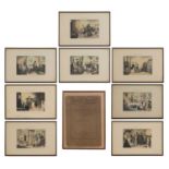
HOGARTH, William: A large volume (Page size: 62 x 48cm), containing almost 90 Engravings: 70 full page engravings and 16 pages with two engravings...
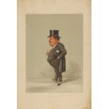
SPY Prints: 27 Original colour prints, including Cricket; commander in chief in INDIA, etc, a few with a small tear to margin and some writing to ...
VEDDER, Simon Harmon:
The next 15 Lots are: Original ARTWORKS for books published by A & C BLACK: VEDDER, Simon Harmon: Six oil on canvas from 'Red Cap Tales' stories f...
JUNGMAN, Nico:
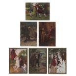
JUNGMAN, Nico: Six Original Artworks for A&C Black’s 'Norway', 1905: including Portraits of: Bjornstjerne Bjornson & Henrik Ibsen (32 x 24cm); Wat...
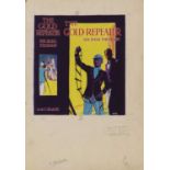
SENDALL, Alfred:
SENDALL, Alfred: Original artwork for the cover of 'The Gold Repeater', a detective story for boys by Sir Basil Thomson, 1936, gouache over pencil...
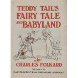
FOLKARD, Charles:
FOLKARD, Charles: Original Artwork for the title pages of: 'Teddy Tail’s Fairy tale & Babyland' 1919; pen and ink and watercolour; And: Grimm’s Fa...
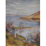
HALL, Rev. Charles A:
HALL, Rev. Charles A: Ten oil on card paintings for 'The Isle of Arran' which A&C Black published in 1912.; (31 x 21cm) (10)Condition ReportPlease...
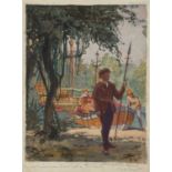
WILKINSON, Norman:
WILKINSON, Norman: Eight watercolours and gouache on card for 'Hakluyt’s first voyage' (26 x 20cm). (8)Condition ReportPlease contact department ...
MATHER, R H:
MATHER, R H: Twelve, each signed, pen & ink on card Ref: Charles I, (20 x 15; & 18 x 13cm). (12) ...[more]