
Filtered by:
- Sale Section
- List
- Grid
This auctioneer has chosen to not publish their results. Please contact them directly for any enquiries.
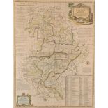

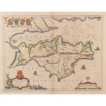
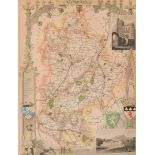
'An Accurate Map of the County of Bedford Divided into its Hundreds', engraved by Emanuel Bowen c.
'An Accurate Map of the County of Bedford Divided into its Hundreds', engraved by Emanuel Bowen c.1749, together with 'A Map of Bedfordshire from ...
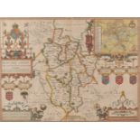
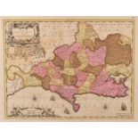
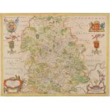
'Bedford Shire and the Situation of Bedford described with the armes of thos Honorable Familyes that
'Bedford Shire and the Situation of Bedford described with the armes of thos Honorable Familyes that have born ye titles of Dukes and Earls thereo...
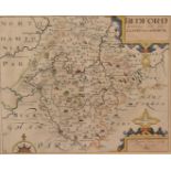
'Bedford Comitatus olim pars Cathfuclanorum' by Christopher Saxon (1543-1610), engraved by Wilhelmus
'Bedford Comitatus olim pars Cathfuclanorum' by Christopher Saxon (1543-1610), engraved by Wilhelmus Kip c.1607, from William Camden's Beds. Brita...

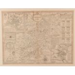
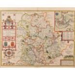
'Bedfordiensis Comitatus Anglis Bedfordshire' by Johannes Blaeu, engraved c.1645 and with hand
'Bedfordiensis Comitatus Anglis Bedfordshire' by Johannes Blaeu, engraved c.1645 and with hand coloured borders and heraldry 41.5cm x 24cm, framed...
'Norhamptonshire' by John Speed (1552-1629), believed to be a first edition 1611/12 early 17th
'Norhamptonshire' by John Speed (1552-1629), believed to be a first edition 1611/12 early 17th century map of Northamptonshire which was published...
'Vectis Insula Anglice The Isle of Wight' by Johannes Blaeu, a hand coloured map engraved c.1645;
'Vectis Insula Anglice The Isle of Wight' by Johannes Blaeu, a hand coloured map engraved c.1645; with coloured borders, cartouche and heraldry, L...
'Comitatus Dorcestria. Vulgo Anglice Dorset Shire' by Joannes Janssonius, hand coloured only to
'Comitatus Dorcestria. Vulgo Anglice Dorset Shire' by Joannes Janssonius, hand coloured only to the hundreds, published in Amsterdam c.1646 by Pie...
![Untitled [Verso-Tabula I Europae] after Ptolemy, this woodcut Ptolemaic map of Albion Insula](https://portal-images.azureedge.net/auctions-2017/srspe10188/images/2d54b409-b0a7-4b3d-e667-3f89a9d3e14d.jpg?w=155&h=155)
Untitled [Verso-Tabula I Europae] after Ptolemy, this woodcut Ptolemaic map of Albion Insula Britannica et Hibernia published by Lorenz Fries c.15...
'Scotiae Tabula' engraved map by Abraham Ortelius, first edition published c.1573 Antwerp, original hand decorated in the beautiful old colour, La...
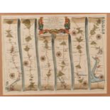
'The Road from Exeter to Barnstable & Thence to Ilfracombe co. Devon' by John Ogilvy Esq., from
'The Road from Exeter to Barnstable & Thence to Ilfracombe co. Devon' by John Ogilvy Esq., from the 'Britannia' by John Ogilby, published in 1675 ...
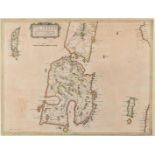
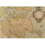
'Ila Insula ex Aebudarum majoribus una, The Yle of Ila being one of the biggest of the Westerne
'Ila Insula ex Aebudarum majoribus una, The Yle of Ila being one of the biggest of the Westerne Yles' (Islay) 40.5cm x 52.5cm after Timothy Pont (...
'Shropshyre Described The Sittuation of Shrowesbury Shewed With the Armies of thos Earles, and other
'Shropshyre Described The Sittuation of Shrowesbury Shewed With the Armies of thos Earles, and other Memorable things observed' engraved map by Jo...
'Comitatus Salopiensis Anglice Shrop Shire' engraved map by Johannes Blaeu, pub. c.1650 Amsterdam in
'Comitatus Salopiensis Anglice Shrop Shire' engraved map by Johannes Blaeu, pub. c.1650 Amsterdam in the 'Theatrum Orbis Terrarumsive Atlas Novus'...
Plate Number Two from the 1765 Map of Devonshire and Exeter by Benjamin Donn, Published according to
Plate Number Two from the 1765 Map of Devonshire and Exeter by Benjamin Donn, Published according to Act of Parliament, January 1st 1765, uncolour...
'Bedfordshire' by William Hole, for Michael Drayton's Poly-Olbion, or Chorographical Description
'Bedfordshire' by William Hole, for Michael Drayton's Poly-Olbion, or Chorographical Description of all the Tracts, Rivers, Mountains, Forests dep...