Filtered by:
- Category
- List
- Grid
A subscription to the Price Guide is required to view results for auctions ten days or older. Click here for more information
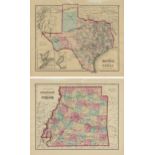

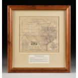
AN ANTIQUE TWO SIDED MAP, "Gray's Atlas Map of Texas," AND "Gray's Atlas Map of Arkansas," PHILADELPHIA, 1874-1896, hand colored cerography on pap...
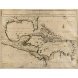
AN ANTIQUE MAP, "Le Golfe de Mexique," PARIS, 1717, hand colored engraving on paper, "Et les Provinces et Isles qui l'Environe comme sont La Flori...
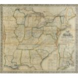
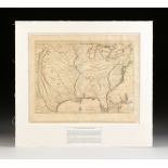
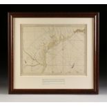
AN ANTIQUE MAP, "Ensign, Bridgman & Fanning's Railroad Map of the United States, Showing the
AN ANTIQUE MAP, "Ensign, Bridgman & Fanning's Railroad Map of the United States, Showing the Depots and Stations," NEW YORK, 1856, hand-colored wi...
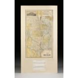
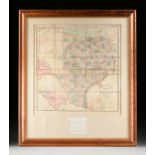
AN ANTIQUE TEXAS RAILWAY MAP, "Map Showing Houston & Texas Central System of Railways," CHICAGO, MAY
AN ANTIQUE TEXAS RAILWAY MAP, "Map Showing Houston & Texas Central System of Railways," CHICAGO, MAY 1890, color wax engraving on paper, Rand McNa...
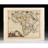
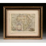
AN ANTIQUE MAP, "Novissima et Perfectissima Africæ," CAREL ALLARD, AMSTERDAM, 17TH/18TH CENTURY,
AN ANTIQUE MAP, "Novissima et Perfectissima Africæ," CAREL ALLARD, AMSTERDAM, 17TH/18TH CENTURY, exquisitely parcel gilt hand colored engraving o...
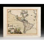
AN ANTIQUE MAP, "Recentissima Novi Orbis sive Americæ Septentrionalis et Meridionalis," CAREL
AN ANTIQUE MAP, "Recentissima Novi Orbis sive Americæ Septentrionalis et Meridionalis," CAREL ALLARD, AMSTERDAM, 17TH/18TH CENTURY, hand colored ...
AN ANTIQUE LATE REPUBLIC OF TEXAS MAP, "New Map of Texas with the Contiguous American & Mexican
AN ANTIQUE LATE REPUBLIC OF TEXAS MAP, "New Map of Texas with the Contiguous American & Mexican States," PHILADELPHIA, 1845, engraved by J.H. Youn...
A RENAISSANCE MAP, "Europæ," ABRAHAM ORTELIUS, ANTWERP, 1570-1612, hand colored copperplate
A RENAISSANCE MAP, "Europæ," ABRAHAM ORTELIUS, ANTWERP, 1570-1612, hand colored copperplate engraving on paper, a fragment from an edition of The...
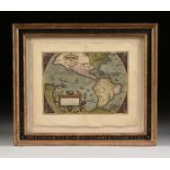
AN ANTIQUE MAP, "Carte de la Louisiane et du Cours du Mississippi," AMSTERDAM, CIRCA 1730, hand
AN ANTIQUE MAP, "Carte de la Louisiane et du Cours du Mississippi," AMSTERDAM, CIRCA 1730, hand colored copperplate engraving on paper, "Dressée ...
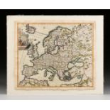
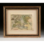
AN ANTIQUE MAP, "Accuratissima Europæ, Multis locis correcta, et Nuperrimé edita," CAREL ALLARD,
AN ANTIQUE MAP, "Accuratissima Europæ, Multis locis correcta, et Nuperrimé edita," CAREL ALLARD, AMSTERDAM, 17TH/18TH CENTURY, parcel gilt hand ...
AN ANTIQUE REPUBLIC OF TEXAS MAP, "Map of Texas," JOHN ARROWSMITH, LONDON, APRIL 17, 1841, hand-
AN ANTIQUE REPUBLIC OF TEXAS MAP, "Map of Texas," JOHN ARROWSMITH, LONDON, APRIL 17, 1841, hand-colored lithograph on paper, by John Arrowsmith, w...
AN ANTIQUE RECONSTRUCTION ERA MAP, "Traveller's Map of the State of Texas," CHARLES M. PRESSLER, NEW
AN ANTIQUE RECONSTRUCTION ERA MAP, "Traveller's Map of the State of Texas," CHARLES M. PRESSLER, NEW YORK, CIRCA 1867, photolithograph with color ...
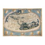
A RENAISSANCE MAP, "Ptolemy Map of the World (Die Weltkarte des Ptolemäus)," ULM AND ARMSHEIM,
A RENAISSANCE MAP, "Ptolemy Map of the World (Die Weltkarte des Ptolemäus)," ULM AND ARMSHEIM, 1482, hand colored woodblock print on paper, "Ins...
A RENAISSANCE MAP, "Americæ sive Novi Orbis, Nova Descriptio," ANTWERP, 1573-1587, a hand colored
A RENAISSANCE MAP, "Americæ sive Novi Orbis, Nova Descriptio," ANTWERP, 1573-1587, a hand colored copperplate engraving on paper, a fragment from...
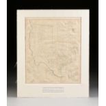
AN ANTIQUE RECONSTRUCTION ERA MAP, "New Map of Texas Prepared and Published for the Bureau of
AN ANTIQUE RECONSTRUCTION ERA MAP, "New Map of Texas Prepared and Published for the Bureau of Immigration of the State of Texas," NEW YORK, 1875, ...
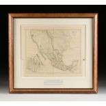
A REPUBLIC OF TEXAS MAP, "Mexico," JOHN ARROWSMITH, LONDON, CIRCA 1842, hand colored engraving on
A REPUBLIC OF TEXAS MAP, "Mexico," JOHN ARROWSMITH, LONDON, CIRCA 1842, hand colored engraving on paper, plate 44, by John Arrowsmith(1790-1873), ...
AN ANTIQUE MAP, "The Western Coast of Louisiana and the Coast of New Leon," LONDON, CIRCA 1775, a
AN ANTIQUE MAP, "The Western Coast of Louisiana and the Coast of New Leon," LONDON, CIRCA 1775, a hand colored engraving on paper, "By Thos. Jeffe...
A RENAISSANCE MAP, "Africæ Tabula Nova," ABRAHAM ORTELIUS, ANTWERP, 1570-1612, a hand colored
A RENAISSANCE MAP, "Africæ Tabula Nova," ABRAHAM ORTELIUS, ANTWERP, 1570-1612, a hand colored copperplate engraving on paper, a fragment from the...
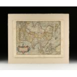
A RENAISSANCE MAP, "Asiæ Nova Descriptio," ABRAHAM ORTELIUS, ANTWERP, 1570-1612, hand colored
A RENAISSANCE MAP, "Asiæ Nova Descriptio," ABRAHAM ORTELIUS, ANTWERP, 1570-1612, hand colored engraving on paper, a fragment from an edition of T...
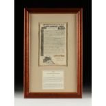
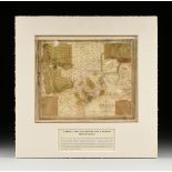
AN EARLY TEXAS EMPRESARIO LAND SCRIP FOR THE DE ZAVALA, VEHLEIN AND BURNET GRANTS, NEW YORK, OCTOBER
AN EARLY TEXAS EMPRESARIO LAND SCRIP FOR THE DE ZAVALA, VEHLEIN AND BURNET GRANTS, NEW YORK, OCTOBER 16TH, 1830, engraving on paper with hand insc...
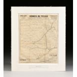
AN ANTIQUE PROMOTIONAL MAP, "Correct Map of Texas," DECEMBER 28, 1876-1880, newsprint on paper
AN ANTIQUE PROMOTIONAL MAP, "Correct Map of Texas," DECEMBER 28, 1876-1880, newsprint on paper with hand coloring, advertising, "Homes in Texas! T...