Filtered by:
- Category,
- Item Type
4 items
- List
- Grid
A subscription to the Price Guide is required to view results for auctions ten days or older. Click here for more information
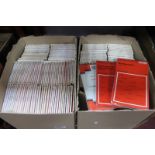

Lot 1063
Ordnance Survey Maps, full sets No's 1 to 190, each priced at 44p and noted on map, Reading 1929:-
Ordnance Survey Maps, full sets No's 1 to 190, each priced at 44p and noted on map, Reading 1929:- Two Boxes
A Plan of Chester, published June 1796 by I. Stockdale, Shropshire, published by G & W.B. Whittaker 1821, Yorkshire by J. Archer, 1838 Russie D'Eu...

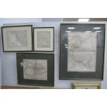
Lot 1407
1804, A New Map of The County of Monmouth, divided into hundreds, printed for C. Smith No. 172
1804, A New Map of The County of Monmouth, divided into hundreds, printed for C. Smith No. 172 Strand, approximately 47 x 42cm, another published ...

Lot 1413
A Map of South Wales, published by W. H. Toms, 1742, approximately 15cm square, others printed for
A Map of South Wales, published by W. H. Toms, 1742, approximately 15cm square, others printed for Carington Bowles, J. Carr 1787, Monmouth exampl...