Filtered by:
- Category,
- Item Type
3 items
- List
- Grid
A subscription to the Price Guide is required to view results for auctions ten days or older. Click here for more information
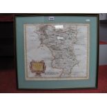

Lot 1435
Robert Mordern, XVIII Century Hand Tinted Map of 'Darbyshire', sold by Abel Swale Awnsham and John
Robert Mordern, XVIII Century Hand Tinted Map of 'Darbyshire', sold by Abel Swale Awnsham and John Churchill, approx. 35 x 41.5cm.
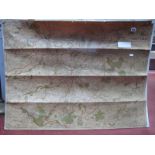
Lot 1436
Circa 1930's Map of Sheffield, produced and published by Geographica Ltd, Fleet St, London,
Circa 1930's Map of Sheffield, produced and published by Geographica Ltd, Fleet St, London, approx. 72 x 95cm.
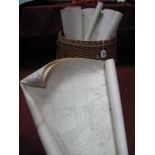
Lot 1437
Earky to Mid XX Century Large Scale O.S. Maps of Yorkshire Areas, approximately thirty-five in
Earky to Mid XX Century Large Scale O.S. Maps of Yorkshire Areas, approximately thirty-five in wicker barrel,