Filtered by:
- Category,
- Item Type
3 items
- List
- Grid
A subscription to the Price Guide is required to view results for auctions ten days or older. Click here for more information
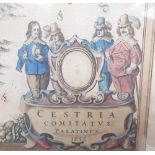

Johannes Jannsonius, Comitatvs Palatinvs, hand coloured map, 1648 53.3cm by 41.cm
Lot 1207
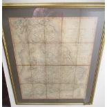
Carys Reduction of his Large Map of England and Wales, with part of Scotland, comprehending the
Carys Reduction of his Large Map of England and Wales, with part of Scotland, comprehending the whole of the turnpike roads, with the great rivers...
Lot 1210
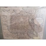
Saxton (Christopher) and Hole (William), Eboracensis East Riding, circa 1607/10, engraved map,
Saxton (Christopher) and Hole (William), Eboracensis East Riding, circa 1607/10, engraved map, titled in cartouche, 19.5 x 25cm,