Filtered by:
- Category
- List
- Grid
This auctioneer has chosen to not publish their results. Please contact them directly for any enquiries.
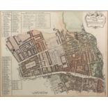

A group of framed maps, undated, to include: a map detailing the wards of Aldersgate, Bishopsgate
A group of framed maps, undated, to include: a map detailing the wards of Aldersgate, Bishopsgate Within & Without, and Bread Street & Cordwainers...
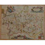
Jan Janssonius, Dutch, 1588-1664, Middelsexiae cum Hertfordiae Comitatu Midlesex & Hertford Shire,
Jan Janssonius, Dutch, 1588-1664, Middelsexiae cum Hertfordiae Comitatu Midlesex & Hertford Shire, 1646,hand-coloured engraved map, 44 x 55cmPleas...
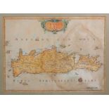
Peyrounin A., Candia Olim Creta, a later hand-coloured engraved map of Crete, published by Pierre
Peyrounin A., Candia Olim Creta, a later hand-coloured engraved map of Crete, published by Pierre Mariette, Paris, circa 1660, 38.5 x 50cmProvenan...
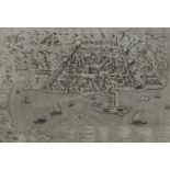
Matteo Florimi, Italian, fl. 1581-1613, plan of the City of Algiers, c. 1600, illustrating the town,
Matteo Florimi, Italian, fl. 1581-1613, plan of the City of Algiers, c. 1600, illustrating the town, fortifications, harbor, man made breakwater ...
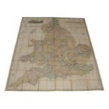
R. Creighton, A Map of England & Wales on a scale of five miles to an inch, c. 1859, engraved by
R. Creighton, A Map of England & Wales on a scale of five miles to an inch, c. 1859, engraved by J. Downer, with hand-coloured county borders and ...