Filtered by:
- Show only bulk lots,
- Category,
- Item Type
- List
- Grid
This auctioneer has chosen to not publish their results. Please contact them directly for any enquiries.
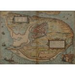

Georg Braun, German 1541-1622 & Franz Hogenberg, Flemish 1535-1590- Brilium Holandiae opp. ob
Georg Braun, German 1541-1622 & Franz Hogenberg, Flemish 1535-1590- Brilium Holandiae opp. ob Intestinum Batauicum Bellum, quod anno partae saluti...
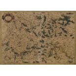
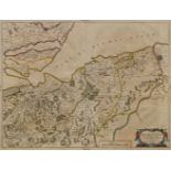
Gerhard Mercator, Flemish 1512-1594- Saxoniae map of Saxony circa 1600; copper engraving with hand-
Gerhard Mercator, Flemish 1512-1594- Saxoniae map of Saxony circa 1600; copper engraving with hand-colouring, Latin text verso, 35x48.5cm, (unfram...
Guiljelmus Blaeu, Dutch 1600-1699- Navarra Regnum & Arragonia Regnum, maps of regions in Spain,
Guiljelmus Blaeu, Dutch 1600-1699- Navarra Regnum & Arragonia Regnum, maps of regions in Spain, 1648; copper engravings, with hand-colouring, two,...
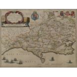
Johannes Blaeu, Dutch 1599-1673 - Comitatus Dorcestria, sive Dorsettia; vulgo Anglice Dorset
Johannes Blaeu, Dutch 1599-1673 - Comitatus Dorcestria, sive Dorsettia; vulgo Anglice Dorset Shire, map of Dorset, circa 1662; copper engraving wi...
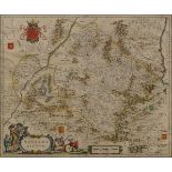
Joan Blaeu, Dutch 1596-1673- Moravia Scotiae provincia, ex Timothei Pont / scedis descripta et aucta
Joan Blaeu, Dutch 1596-1673- Moravia Scotiae provincia, ex Timothei Pont / scedis descripta et aucta per Robert: Gordonium a Strathloch map of Mor...
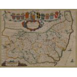
Joan Blaeu, Dutch 1596-1673- Suffolicia Vernacule Suffolke, map of Suffolk 1645; copper engraving
Joan Blaeu, Dutch 1596-1673- Suffolicia Vernacule Suffolke, map of Suffolk 1645; copper engraving with hand-colouring, Latin text verso, 38.2x50.2...
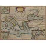
Johannes Janssonius, Dutch 1588-1664- Aragonau Tica, map of the voyage of the Argonaut, circa
Johannes Janssonius, Dutch 1588-1664- Aragonau Tica, map of the voyage of the Argonaut, circa 1740; copper engraving with hand-colouring, 39.4x5...
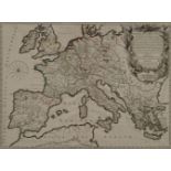
Gilles Robert de Vaugondy, French 1686-1766- Imperium Carolimagni, map of Ancient Europe circa 1745;
Gilles Robert de Vaugondy, French 1686-1766- Imperium Carolimagni, map of Ancient Europe circa 1745; copper engraving with hand-colouring, 48x65cm...
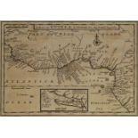
Herman Moll, German/English 1654-1732- A Map of Guinea, Loango etc & A Map of Zaara of the Desart,
Herman Moll, German/English 1654-1732- A Map of Guinea, Loango etc & A Map of Zaara of the Desart, Negroland & Cape Verde Islands etc, circa 1711;...
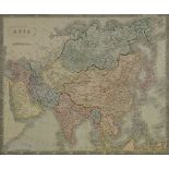
Sidney Hall, British 1788-1831- Asia, map circa 1853; engraving with hand-colouring, 45.2x55.2cm:
Sidney Hall, British 1788-1831- Asia, map circa 1853; engraving with hand-colouring, 45.2x55.2cm: together with a quantity of engravings, most han...
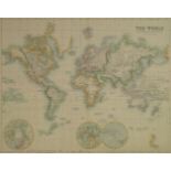
George Heriot Swanston, British b.1814- The World on Mercator's Projection, 1850; engraving with
George Heriot Swanston, British b.1814- The World on Mercator's Projection, 1850; engraving with hand-colouring, publ. by A. Fullerton & Co., Lond...