Filtered by:
- Sale Section,
- Category
- List
- Grid
This auctioneer has chosen to not publish their results. Please contact them directly for any enquiries.
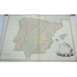

A late 18th Century hand coloured map of Spain and Portugal divided into their respective kingdoms
A late 18th Century hand coloured map of Spain and Portugal divided into their respective kingdoms and provinces, published by W. Faden 1796
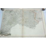
A late 18th Century hand coloured map of the South Eastern part of France, published by W. Faden
A late 18th Century hand coloured map of the South Eastern part of France, published by W. Faden 1799
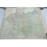
A late 19th Century hand coloured map of the German Empire and the neighbouring states, by William
A late 19th Century hand coloured map of the German Empire and the neighbouring states, by William Faden, 1788
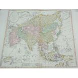
A late 18th Century hand coloured map of Asia, divided into its empires, kingdoms, states, and other
A late 18th Century hand coloured map of Asia, divided into its empires, kingdoms, states, and other subdivisions, including an inset map of New H...
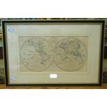
Benjamin Baker: a Hogarth framed late 18th Century twin hemisphere world map - from the Universal
Benjamin Baker: a Hogarth framed late 18th Century twin hemisphere world map - from the Universal Magazine, plate 1
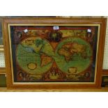
Two reproduction maple framed pictures on glass, depicting twin hemisphere maps of the world after
Two reproduction maple framed pictures on glass, depicting twin hemisphere maps of the world after Henry Hondius
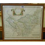
Robert Morden: a framed 17th Century hand coloured map print 'The County Palatine of Chester'
Robert Morden: a framed 17th Century hand coloured map print 'The County Palatine of Chester'