
Filtered by:
- Category,
- Creator / Brand
- List
- Grid
A subscription to the Price Guide is required to view results for auctions ten days or older. Click here for more information
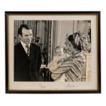

H.R.H. Princess Anne The Princess Royal and Captain Mark Phillips signed 1977 portrait photograph
H.R.H. Princess Anne The Princess Royal and Captain Mark Phillips - signed 1977 portrait photograph of the couple with their first child - in glaz...
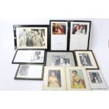
T.R.H. Prince and Princess Michael of Kent signed presentation photograph in glazed frame, six other framed Royal Christmas cards and other framed...
HRH Prince Charles Prince of Wales - large signed presentation portrait photograph of The Prince seated, signed in ink on mount 'Charles 1985', in...
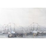
John Christian Schetky, Early 19th century proof aquatint 'Arrival of King George in Royal Flotilla at Leith', hand inscription by the artist dedi...
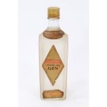
Gin - one bottle, Gilbey's London Dry Gin, U.S . Proof
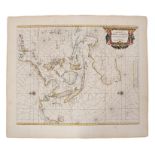
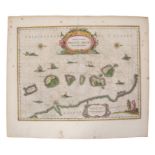
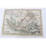
Guijelmus Blaeu (1571-1638), hand-coloured map - ‘Moluccae Insulae Celeberrimae’, 1630, German text
Guijelmus Blaeu (1571-1638), hand-coloured map - ‘Moluccae Insulae Celeberrimae’, 1630, German text verso, 38cm x 48cm.Condition report: Minor los...
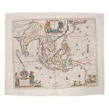
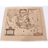
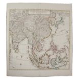
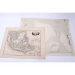
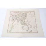
Guiljelmus Blaeu (1571-1638), hand-coloured map - ‘India que Orientalis dicitur et Insulae Adiacentes’, 1635, Dutch text verso, 45cm x 51cmConditi...
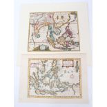
Philippe Cluver (1580-1622), hand-coloured map - ‘Indiae Orientalis’, 22cm x 26cm, 1697, together
Philippe Cluver (1580-1622), hand-coloured map - ‘Indiae Orientalis’, 22cm x 26cm, 1697, together with another - ‘Isles de L’Indie Orientale’ (2)....
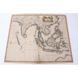
Hendrik Doncker (1626-1699), hand-coloured map - ‘Oost Indien’, 1670, 43cm x 53cm.Condition report: minor stains to borders foxing, generally good...
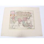
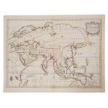
Nicolas de Fer (1646-1720), hand-coloured map - ‘L’ Asie’, dated 1722, 47cm x 60cmCondition report: Some repairs, transference of ink and staining...
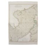
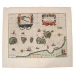
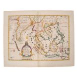
Capt, George Hayter (18th century), hand-coloured map - ‘A General Chart of the China Sea’, dated
Capt, George Hayter (18th century), hand-coloured map - ‘A General Chart of the China Sea’, dated 1778, 84cm x 62cm.Condition report: Good conditi...
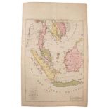
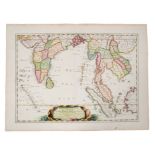
Homan Heirs (1730-1813), hand-coloured map - ‘Indes Orientalis’, dated 1748, 50cm x 89cm.Condition report: patch repairs to top and bottom edges a...

Henricus Hondius (1597-1651), hand-coloured map - ‘India Orientalis ..Insulae Adiacentes’, 1638,
Henricus Hondius (1597-1651), hand-coloured map - ‘India Orientalis ..Insulae Adiacentes’, 1638, French text verso, 39cm x 49cm.Condition report: ...
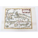
Jan Jansson (1596-1664), hand-coloured map - ‘Insularum Moluccarum’, 1656-1661, English text verso,
Jan Jansson (1596-1664), hand-coloured map - ‘Insularum Moluccarum’, 1656-1661, English text verso, 39cm x 50cm.Condition report: Various signific...
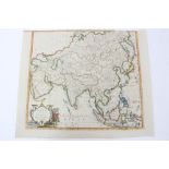
Jodocus Hondius (1563-1612), hand-coloured map - ‘Asiae Nova Decsriptio Auctore’, 1606, 37cm x 50cm.
Jodocus Hondius (1563-1612), hand-coloured map - ‘Asiae Nova Decsriptio Auctore’, 1606, 37cm x 50cm.Condition report: Discolouration, pin holes to...
Henricus Hondius (1597-1651), hand-coloured map - ‘India Orientalis ..Insulae Adiacentes’, 1638,
Henricus Hondius (1597-1651), hand-coloured map - ‘India Orientalis ..Insulae Adiacentes’, 1638, Latin text verso, 39cm x 49cm.Condition report: P...
Jan Jansson (1596-1664), hand-coloured map - ‘Insularum Moluccarum’, 39cm x 50cmCondition report: minor staining ...[more]
Edward Wells (1667-1727), hand-coloured map - ‘A New Map of the East Indies’, 1700, 36cm x 50cm.
Edward Wells (1667-1727), hand-coloured map - ‘A New Map of the East Indies’, 1700, 36cm x 50cm.Condition report: Minor stains ...[more]

Edward Wells (1667-1727), hand-coloured map - ‘A New Map of the East Indies’, 1700, 36cm x 50cm
Edward Wells (1667-1727), hand-coloured map - ‘A New Map of the East Indies’, 1700, 36cm x 50cmCondition report: significant staining to spine, re...
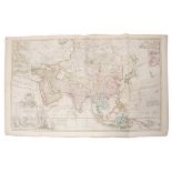
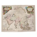
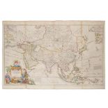
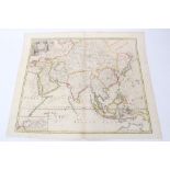
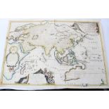
Herman Moll (d. 1732), large hand-coloured map - ‘Asia’, presentation to William, Lord Cowper, Lord
Herman Moll (d. 1732), large hand-coloured map - ‘Asia’, presentation to William, Lord Cowper, Lord High Chancellor of Great Britain’, printed – D...
Jan Jansson (1596-1664), hand-coloured map - ‘Sumatrae’ 1657-1658, 42cm x 52cmCondition report: minor disrepair to border ...[more]
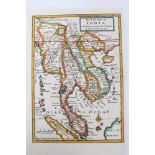
John Senex (d.1740), hand-coloured map - ‘A New Map of India and China’, 1721, 50cm x 59cm.Condition report: A few tape repairs to margins, stains...

Thomas Kitchin (1718-1784), hand-coloured map - ‘Asia / From the best authorities’, 18cm x 23cm.
Thomas Kitchin (1718-1784), hand-coloured map - ‘Asia / From the best authorities’, 18cm x 23cm.Condition report: good condition ...[more]
Guillaume de L’Isle (1675-1726), hand-coloured map - ‘Carte des indes et de la Chine’, ‘Chez Jean
Guillaume de L’Isle (1675-1726), hand-coloured map - ‘Carte des indes et de la Chine’, ‘Chez Jean Covens et Corneille Mortier’, 1700, 62cm x 63cm....
William Home Lizar (1788-1859), coloured engraving - ‘Part of Asia’, 38cm x 45cm., together with Emile Levasseur (1828-1911), two hand-coloured en...
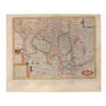
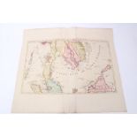
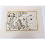
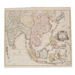
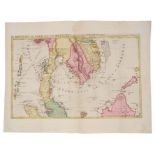
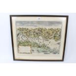
Pierre Mortier (1661-1711), hand-coloured map - ‘lLe Royaume de Siam avec les Royaumes qui luy font
Pierre Mortier (1661-1711), hand-coloured map - ‘lLe Royaume de Siam avec les Royaumes qui luy font tributaries et les Isles de Sumatra Andemaon e...
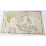
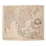
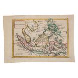
Charles Theodore Middleton, hand-coloured map - ‘An accurate map of the East Indies.’ (1777-1779),
Charles Theodore Middleton, hand-coloured map - ‘An accurate map of the East Indies.’ (1777-1779), from Complete System of Geography, 20cm x 30cm....
J. Migeon, coloured engraving - ‘Indo-Chine et Archipel D’Asie, 1890, 31cm x 42cm, together with
J. Migeon, coloured engraving - ‘Indo-Chine et Archipel D’Asie, 1890, 31cm x 42cm, together with Claudio Montero - ‘Baie de Manille’, 1874 (2).
Herman Moll (d. 1732), large hand-coloured map - ‘Asia’ presentation to William, Lord Cowper, Lord
Herman Moll (d. 1732), large hand-coloured map - ‘Asia’ presentation to William, Lord Cowper, Lord High Chancellor of Great Britain’, printed by T...
Joachim Ottens (17th / 18th century), hand-coloured map - ‘Le Royaume de Siam Avec Les Royaumes qui
Joachim Ottens (17th / 18th century), hand-coloured map - ‘Le Royaume de Siam Avec Les Royaumes qui Luy sont tributaires’, 1740, 36cm x 46cm.
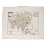
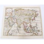
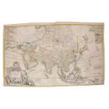
Franz Johann Joseph Von Reilly (1766-1820), hand-coloured map - ‘Karte von Asien’, 51cm x 66cm.
Franz Johann Joseph Von Reilly (1766-1820), hand-coloured map - ‘Karte von Asien’, 51cm x 66cm.Condition report: Some deterioration to margins, ma...
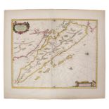
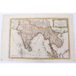
Nicolas Sanson (1600-1667), hand-coloured map - ‘Partie Meridionale de l’Inde’, dated 1654, 38cm x
Nicolas Sanson (1600-1667), hand-coloured map - ‘Partie Meridionale de l’Inde’, dated 1654, 38cm x 52cm.Condition report: Browning at periphery, s...
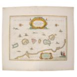
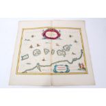
Heinrich Scherer (1628-1704), hand-coloured map - ‘Insularum Marianarum cum Insulis De Pais
Heinrich Scherer (1628-1704), hand-coloured map - ‘Insularum Marianarum cum Insulis De Pais Marianis....’ circa 1700, 23cm x 35cm.Condition report...
Nicholas Sanson (1600-1667, hand coloured map ‘Insulae Moluccae’, 1720, 19 x 25cmCondition report: Couple of tape repairs or tears, small tear to ...
Isaak Tirion (d.1769), hand-coloured map - ‘Nieuwe Kaart van Asia’, 28cm x 36cm, 1740Condition report: Minor creases and fox marks ...[more]
Isaak Tirion (d.1769), hand-coloured map - ‘Nieuwe Kaart van Asia’, 28cm x 36cm, 1740Condition report: Trimmed margins, minor marks, generally ok ...

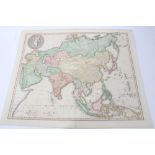
Nicolas Vischer (1618-1679), hand-coloured map - ‘Asiae Nova Delineato’, 1680, 46cm x 54cm.
Nicolas Vischer (1618-1679), hand-coloured map - ‘Asiae Nova Delineato’, 1680, 46cm x 54cm.Condition report: Minor fox marks, staining, generally ...
Edward Wells (1667-1727), hand-coloured map - ‘Present Asia’, 1701, 37cm x 51cm.Condition report: minor stains, generally good ...[more]
James Wyld the Elder (1790-1836), hand-coloured map - ‘Asia’, 1827, 52cm x 64cm.Condition report: Couple of tape repairs to top edge, minor marks ...
Frederick de Wit (1610-1698), hand-coloured map - ‘Tabula Indiae Orientalis’, dated 1662, 47cm x
Frederick de Wit (1610-1698), hand-coloured map - ‘Tabula Indiae Orientalis’, dated 1662, 47cm x 56cmCondition report: Some losses to margins, bro...

Antonio Zatta (fl. 1757-1797), hand-coloured map - ‘Indie Orientali’, published Venice 1784, 33cm x
Antonio Zatta (fl. 1757-1797), hand-coloured map - ‘Indie Orientali’, published Venice 1784, 33cm x 42cmCondition report: Generally good ...[more]
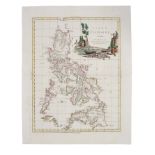
Antonio Zatta (fl. 1757-1797), hand-coloured map - ‘Isole Filippine’ published Venice 1784, 33cm x
Antonio Zatta (fl. 1757-1797), hand-coloured map - ‘Isole Filippine’ published Venice 1784, 33cm x 42cmCondition report: Generally good ...[more]
Herman Moll (d. 1732), large hand-coloured map - ‘Asia’ presentation to William, Lord Cowper, Lord
Herman Moll (d. 1732), large hand-coloured map - ‘Asia’ presentation to William, Lord Cowper, Lord High Chancellor of Great Britain’, printed D. M...
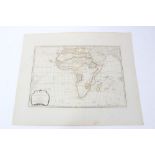
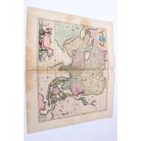
Samuel Dunn (d 1794), hand-coloured map - ‘Africa and its several regions', published Laurie &
Samuel Dunn (d 1794), hand-coloured map - ‘Africa and its several regions', published Laurie & Whittle, 1794, 33cm x 46cm.Condition report: Minor ...
John Senex (d.1740), hand-coloured map - ‘A New Map of India and China’, 1721, 50cm x 59cmCondition report: minor time staining, generally good ....
Joachim Ottens (17th/18th century), hand-coloured map - ‘Le Royaume de Siam Avec Les Royaumes gui
Joachim Ottens (17th/18th century), hand-coloured map - ‘Le Royaume de Siam Avec Les Royaumes gui Luy sont tributaires’, 1740, 36cm x 46cm.Conditi...
John Senex (d.1740), hand-coloured map - ‘A New Map of Asia’, 1721, 50cm x 59cm
N Visscher - hand coloured map - ‘Asiae Nova Delineatio’, circa 1680, 43 x 54cmCondition report: Significant damp or other stains particularly to ...
Herman Moll (d. 1732) hand coloured map - ‘The Principle Islands of the East Indies’, 18 x 26
Herman Moll (d. 1732) hand coloured map - ‘The Principle Islands of the East Indies’, 18 x 26Condition report: Minor time stains, generally good ...
Herman Moll (d. 1732) hand coloured map - ‘The Philippine Islands and others of the East Indies’,
Herman Moll (d. 1732) hand coloured map - ‘The Philippine Islands and others of the East Indies’, 18 x 26
Herman Moll (d. 1732) hand coloured map - ‘The East Part of India’, 26 x 16cm
Jan Jansson (1596-1664), hand-coloured map - ‘Insularum Moluccarum’, 39cm x 50cm
Thomas Conder (1775-1801), hand coloured map - ‘Asia’, 1778, 34cm x 39cm
John Cary (c. 1754-1835), hand-coloured map - ‘A New Map of Asia’, 1806, 52 x 57cm
Father Vincenzo Maria Coronelli (1650-1718) hand coloured map - ‘Asia’ circa 1690, 59 x 87cm
Father Vincenzo Maria Coronelli (1650-1718) hand coloured map - ‘Asia’ circa 1690, 59 x 87cm
18th century hand-coloured engraving - The Bay & Harbour of Vigo, together with two reprints of
18th century hand-coloured engraving - The Bay & Harbour of Vigo, 38 x 48cm, together with two reprints of local 18th century engravings - Harwich...
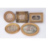
Group of five Bartolozzi style stipple engravings, each depicting figures, in period gilt frames, the largest 18 x 20cm (oval). (5)
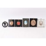
Early 19th century wax seal profile of Wellington, signed Brook, in glazed mount and papier mache frame, 10cm square, together with profile waterc...
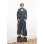
Large painted dummy board
Large painted dummy board - ‘The Blue Coat Boy, Ipswich’ from the pub of the same name, Cattle Market, Ipswich, closed circa 1989, 166cm high
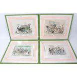
Decorative set of six 19th century Italian overpainted prints, depicting scenes of carnival, 24 x
Decorative set of six 19th century Italian overpainted prints, depicting scenes of carnival, 24 x 29cm. glazed frames Provenance: Georgina Fairhol...