
Refine your search
Filtered by:
- Sale Section,
- Category,
- Creator / Brand
- List
- Grid
A subscription to the Price Guide is required to view results for auctions ten days or older. Click here for more information
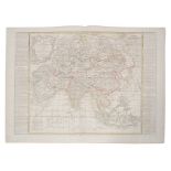

Jean Baptiste Nolin (1657-1725), hand-coloured map - ‘L’Asie’, with updates by L. Denis, 1817, 50cm
Jean Baptiste Nolin (1657-1725), hand-coloured map - ‘L’Asie’, with updates by L. Denis, 1817, 50cm x 67cm.Condition report: minor stains, general...
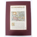
Tomasso Poracchi (1539-1585), hand-coloured map with accompanying Latin text - ‘Descrttione
Tomasso Poracchi (1539-1585), hand-coloured map with accompanying Latin text - ‘Descrttione Dell’Isole Molucca’, 1572, image 11cm x 15cm.Condition...
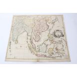
John Senex (d.1740), hand-coloured map - ‘A New Map of India and China’, 1721, 50cm x 59cm.
John Senex (d.1740), hand-coloured map - ‘A New Map of India and China’, 1721, 50cm x 59cm.Condition report: some losses and numerous tape repairs...
Jan Jansson (1588-1664) hand coloured map - ‘Alsatia Inferior’ published Amsterdam, circa 1640
Jan Jansson (1588-1664) hand coloured map - ‘Alsatia Inferior’ published Amsterdam, circa 1640, 36 x 43cm, glazed frame
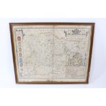
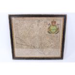
John Speede and John Norden, hand coloured map of Essex, dated 1662, 42 x 52cm, glazed frame