
Filtered by:
- Category,
- Item Type
4 items
- List
- Grid
A subscription to the Price Guide is required to view results for auctions ten days or older. Click here for more information
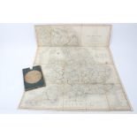

Lot 622
Late 18th / early 19th century engraved folding cloth map of England and Wales by John Cary 'Cary's
Late 18th / early 19th century engraved folding cloth map of England and Wales by John Cary 'Cary's reduction of his large map', handcoloured, 76 ...
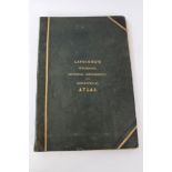
Lavoisne's Genealogical, Historical Chronological and Geographic Atlas, Fourth Edition, Gardiner & Son, London 1843 - containing coloured maps and...
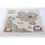
Lot 1070
Johann and Cornel Blaeu, seventeenth century hand coloured engraved map - Ischia, unframed, 44.
Johann and Cornel Blaeu, seventeenth century hand coloured engraved map - Ischia, unframed, 44.5cm x 55cm
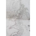
Lot 1071
Jean-Baptiste Bourguignon D'Anville (1697-1782) collection of eleven hand coloured engraved folding
Jean-Baptiste Bourguignon D'Anville (1697-1782) collection of eleven hand coloured engraved folding maps, in antique folio