Filtered by:
- Category,
- Item Type
4 items
- List
- Grid
A subscription to the Price Guide is required to view results for auctions ten days or older. Click here for more information
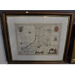

Lot 131
John Blaeu, original 18th Century map of Cardiganshire, 37.5 x 50cm approx. Sparsely coloured,
John Blaeu, original 18th Century map of Cardiganshire, 37.5 x 50cm approx. Sparsely coloured, modern, glazed frame.(B.P. 21% + VAT)
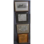
Lot 134
An original coloured map of Caermardi by Christopher Saxton, together with two reproduction maps (
An original coloured map of Caermardi by Christopher Saxton, together with two reproduction maps (prints) 'The Countye of Monmouth' by John Sppede...
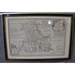
Lot 144
An Accurate Map of Brecknockshire' drawn from an actual survey. By Thomas Kitchin. Framed and
An Accurate Map of Brecknockshire' drawn from an actual survey. By Thomas Kitchin. Framed and glazed.(B.P. 21% + VAT)
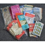
Lot 364
Small box containing ordinance survey maps etc. of England and Scotland dating from the 1940s
Small box containing ordinance survey maps etc. of England and Scotland dating from the 1940s onwards, also a National Grid Seventh Series collect...