Refine your search
Filtered by:
- Category,
- Item Type
- List
- Grid
A subscription to the Price Guide is required to view results for auctions ten days or older. Click here for more information


Gilt framed coloured print of a Coaching Inn Ale House scene
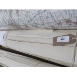
Approx. 22 maps of similar scale and age of areas principally in Nottinghamshire incl. Thorpe, Kirlklngton, Caunton, Sutton in Ashfield, Balderton...
Approx.
Approx. 16 maps of similar scale covering local areas of Biscathorpe, Wragby, Market Rasen, Linwood, The Kelsey's et. circa
Approx.
Approx. 10 maps of similar scale and age covering Immingham, Holton le Clay, West Keal, Beelsby, Irby, Ingoldmells et. circa
Approx.
Approx. 10 Ordnance Survey maps of similar age and scale including Edlington, Tupholme, Skirbeck, Thimbleby, Wispington, Chapel Hill and Spalding
Approx.
Approx. 5 Ordnance Survey maps of similar age and scale covering Besthorpe, Swinderby, Morton, Claypole, Colby and Thorpe on the Hill
Approx.
Approx. 18 Ordnance Survey sheets of similar age and scale covering Snitterby, Harpswell, Bishop Norton, Ingham, Langworth et. circa
Approx.
Approx. 12 Ordnance Survey maps covering the villages of Boothby, Graffoe, Navenby, Bassingham, Caythorpe, Welbourne etc.
Approx.
Approx. 8 maps of similar age and size (some duplication) covering Coleby, Harmston, Thorpe on the Hill, Hykeham, etc.
Approx.
Approx. 19 Ordnance Survey plans of similar age and scale covering the Lincolnshire/Nottinghamshire borders incl. Harby, Ollerton, Saxilby, Eagle ...
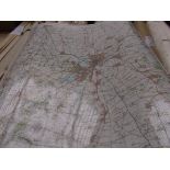
Ordnance Survey Land Ranger map scale 1:50000 of Lincoln and Newark on Trent (laminated)
Plan tube, 1;2500 1907 edition Ordnance Survey sheets of Caistor Moor and Nettleton, Tate Gallery Dufy print, Burton Hunt Point to Point, April 19...
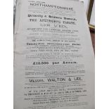
Most valuable 1911 edition of The Sale of Apethorpe Estate, Northhamptonshire 1892 inset coloured maps
Selection of approx.
Selection of approx. 24 Ordnance Survey Explorer Maps and others, 5 compartment desk tidy
Approx.
Approx. 25 Ordnance Survey maps principally of Lincolnshire and surrounding areas
Approx.
Approx. 20 Ordnance Survey Explorer and Land maps principally of Lincolnshire circa
Osgoods Maritime Provinces incl.
Osgoods Maritime Provinces incl. maps and plates for Travellers to America dated 1881