Filtered by:
- Category
- List
- Grid
This auctioneer has chosen to not publish their results. Please contact them directly for any enquiries.
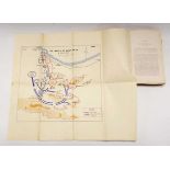

1st. Edition. Published for private circulation in the British Army of the Rhine. 8vo. Hb. Blue cloth, gilt with heraldic emblem on upper board. T...
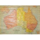
Johnston W. & A.K. and Bacpn G.W. : Australia & Tasmania, C.1955. Large scale coloured 'Political'
Johnston W. & A.K. and Bacpn G.W. : Australia & Tasmania, C.1955. Large scale coloured 'Political' map of the country in the form of a glazed, li...
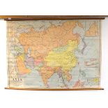
Johnston W. & A.K. and Bacon G.W. : Asia C.1955. Large scale coloured 'Political' map of the
Johnston W. & A.K. and Bacon G.W. : Asia C.1955. Large scale coloured 'Political' map of the continent in the form of a glazed, linen-backed wall...
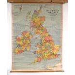
Johnston W. & A.K. and Bacon G.W. : Great Britain and Ireland, C.1959. Large scale coloured '
Johnston W. & A.K. and Bacon G.W. : Great Britain and Ireland, C.1959. Large scale coloured 'Political' map of the Islands in the form of a glaze...
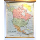
Johnston W. & A.K. and Bacon G.W. : North America C.1955. Large scale coloured 'Political' map of
Johnston W. & A.K. and Bacon G.W. : North America C.1955. Large scale coloured 'Political' map of the continent including Canada, Greenland, U.S...
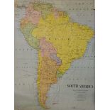
Johnston W. & A.K. and Bacon G.W. : South America C.1955. Large scale coloured 'Political' map of
Johnston W. & A.K. and Bacon G.W. : South America C.1955. Large scale coloured 'Political' map of the continent featuring the different countrie...
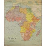
Johnston W. & A.K. and Bacon G.W. : Africa, C.1959. Large scale coloured 'Political' map of the
Johnston W. & A.K. and Bacon G.W. : Africa, C.1959. Large scale coloured 'Political' map of the continent featuring the different countries. Brit...
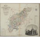
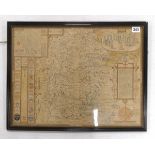
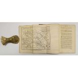
Greenwood (C. & J.) : Northamptonshire.-Map of the County of Northampton from an Actual Survey
Greenwood (C. & J.) : Northamptonshire.-Map of the County of Northampton from an Actual Survey made in the Years 1825 & 1826, detailed hand-colour...
Saxton (Christopher and William Kipp) : Cumbria, Sive Cumberlandia Qua Olim Pars Brigantum, circa
Saxton (Christopher and William Kipp) : Cumbria, Sive Cumberlandia Qua Olim Pars Brigantum, circa 1637. Engraved map, hand-coloured in outline, t...
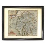
Saxton (Christopher and William Kipp) : Notingamiae Comitatus olim coritanorum, circa 16550.
Saxton (Christopher and William Kipp) : Notingamiae Comitatus olim coritanorum, circa 16550. Engraved map, hand-coloured in outline, framed and ...
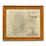
Speed (John) : Wiltshire, ( 1552-1629 ). An engraved county map with inset town plan of Salisbury
Speed (John) : Wiltshire, ( 1552-1629 ). An engraved county map with inset town plan of Salisbury and a vignette of Stonehenge, sold by Thomas Ba...
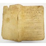
A New Tour Through England Performed in the Summers of 1765, 1766 and 1767 by George Beaumont,
A New Tour Through England Performed in the Summers of 1765, 1766 and 1767 by George Beaumont, Esq; and Capt. Henry Disney : Describing whatever i...
Nathaniel Kinderley : Ancient and Present State of the Navigation of the Towns of Lynn, Wisbeach,
Nathaniel Kinderley : Ancient and Present State of the Navigation of the Towns of Lynn, Wisbeach, Spalding and Boston; of the Rivers that pass th...
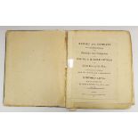
John Rennie : Report and Estimate on the Improvement of the Drainage and Navigation of the South &
John Rennie : Report and Estimate on the Improvement of the Drainage and Navigation of the South & Middle Levels of the Great Level of the Fens. I...