Refine your search
Filtered by:
- Category,
- Item Type
2 items
- List
- Grid
This auctioneer has chosen to not publish their results. Please contact them directly for any enquiries.


Ordnance Survey Regional Maps, mainly Buckinghamshire, some bordering Oxfordshire. Majority dated1880, some 1920s. Large Scale, ( 25.4" - statute ...
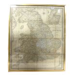
Lot 310
Wyld J.
Wyld J. : Map of England, Wales & Scotland Describing Direct & Principal Cross Roads, Great Rivers & Navigable Canals, 1833. Folding, linen-backe...