Filtered by:
- Category,
- Item Type
- List
- Grid
This auctioneer has chosen to not publish their results. Please contact them directly for any enquiries.
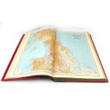

The Survey Atlas of England and Wales, (Bartholomew), 1939. Folio, fine qtr. binding in maroon morocco, gilt, teg, marbled eps. Topographical colo...

Cartography Reference Collection. Portinaro : Cartography of North America 1500 - 1800; Seymour : History of the Ordnance Survey; Joan Blaeu - Atl...
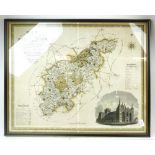
Greenwood C. & J. : Map of the County of Northampton, 1825/26. Engraved titular cartouche, hand coloured, engraved vignette of Peterborough Cathed...
John Speed : Bedford Shire and the situation of Bedford described, Map dated 1676 - Bassett & Chiswell edition. Hand coloured heraldic cartouche, ...
West Coast of England Pilot.
West Coast of England Pilot. From the Scilly Isles to Mull of Galloway including the Isle of Man, Eighth Ed. 1933. Together with Supplement 3. 8vo...
Gerard Mercator : Decorative early map of the Northeast of England, comprising the counties of Yorkshire, Lincolnshire, Derbyshire, Staffordshire,...

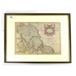
John Speed : Northamptonshire',
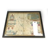
John Speed : Northamptonshire', with inset town plans of Northampton and Peterborough and Armorial Shields hand coloured engraved map, with index ...
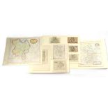
A collection of 9 mounted maps of Bedfordfshire, Cambridgeshire and Huntingdonshire featuring 4 miniature John Speed county maps, Morden's Hunting...