454
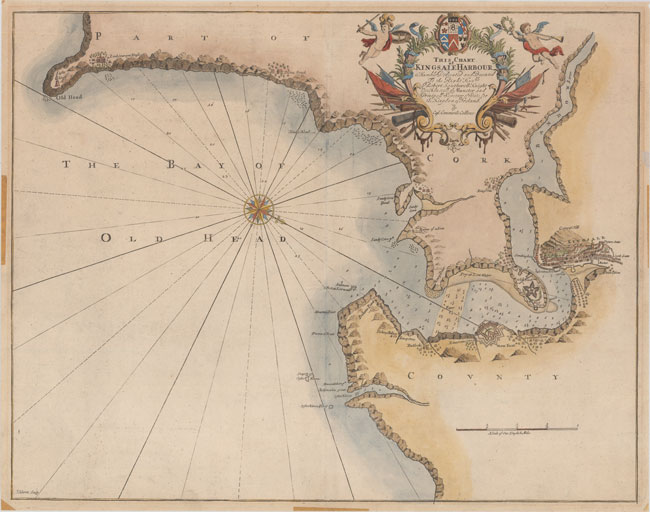
This Chart of Kingsale Harbour Is Humbly Dedicated and Presented to the Right Honble Sr. Robert


Description
This Chart of Kingsale Harbour Is Humbly Dedicated and Presented to the Right Honble Sr. Robert Southwell...
This handsome chart focuses on a portion of County Cork in southwest Ireland, where the River Bandon meets the Bay of Old Head. The fishing village of Kinsale is prominently featured as a dense cluster of buildings in the shadow of Compass Hill. Across the River Bandon is an Old Fort, with a new, larger fort depicted down the river, past Summers Cove. Various other coves are located along the coast, as are sites of interest such as the lighthouse at Old Head, Fishing Pallace, Ruines of a Forte, and Lord Courcyes House. Within the water there are numerous soundings and hazards, as well as a compass rose capped with a fleur-de-lis that radiates rhumb lines and orients north to the lower right corner. Cannons and flags jut from an elaborate cartouche flanked by putti that encloses a dedication to Sir Robert Southwell. Engraved by J. Harris.
In 1681 Capt. Greenville Collins (fl.1669-1694) an officer in the Royal Navy was appointed by the Admiralty to make a complete survey of the coasts of Great Britain. Prior to this date the charts used by English mariners were copies of Dutch charts that had many inaccuracies. The task of surveying the entire coasts was formidable and took about 7 years, at the end of which only 46 surveys were finally used in an atlas titled ""Great Britain`s Coasting-Pilot Being a New and Exact Survey of the Sea-Coast of England,"" which was first published in 1693.
Nice impression and color with light soiling and a printer`s crease adjacent to the centerfold. There are remnants of hinge tape in the blank margins on recto.
17.6 W x 22.3 H
Collins, Capt. Greenvile 1693
Auction Details
Shipping
T&Cs & Important Info
Ask seller a question
This Chart of Kingsale Harbour Is Humbly Dedicated and Presented to the Right Honble Sr. Robert Southwell...
This handsome chart focuses on a portion of County Cork in southwest Ireland, where the River Bandon meets the Bay of Old Head. The fishing village of Kinsale is prominently featured as a dense cluster of buildings in the shadow of Compass Hill. Across the River Bandon is an Old Fort, with a new, larger fort depicted down the river, past Summers Cove. Various other coves are located along the coast, as are sites of interest such as the lighthouse at Old Head, Fishing Pallace, Ruines of a Forte, and Lord Courcyes House. Within the water there are numerous soundings and hazards, as well as a compass rose capped with a fleur-de-lis that radiates rhumb lines and orients north to the lower right corner. Cannons and flags jut from an elaborate cartouche flanked by putti that encloses a dedication to Sir Robert Southwell. Engraved by J. Harris.
In 1681 Capt. Greenville Collins (fl.1669-1694) an officer in the Royal Navy was appointed by the Admiralty to make a complete survey of the coasts of Great Britain. Prior to this date the charts used by English mariners were copies of Dutch charts that had many inaccuracies. The task of surveying the entire coasts was formidable and took about 7 years, at the end of which only 46 surveys were finally used in an atlas titled ""Great Britain`s Coasting-Pilot Being a New and Exact Survey of the Sea-Coast of England,"" which was first published in 1693.
Nice impression and color with light soiling and a printer`s crease adjacent to the centerfold. There are remnants of hinge tape in the blank margins on recto.
17.6 W x 22.3 H
Collins, Capt. Greenvile 1693
Antique Maps, Charts, Atlases, Books, Prints, and Medieval Manuscripts
Sale Date(s)
Venue Address
www.oldworldauctions.com
Virginia
United States
General delivery information available from the auctioneer
We have a full service shipping department to ensure proper packing and safe delivery of purchases at reasonable cost. We are specialists at packing and shipping antique maps, books and works on paper. All lots purchased by the same client are combined for shipping in order to keep the cost as economical as possible. Domestic shipments are typically sent UPS Ground or USPS Priority Mail, but we can accommodate other shipping preferences. For international orders we select the most appropriate carrier depending on the value and weight of the items purchased. We are happy to accommodate special arrangements by request.
Important Information
Viewing:
May 5 to May 21 from 8:30 AM - 5:00 PM Eastern (10PM UK time).
Please call or email for an appointment.
Delivery Info:
We have a full service shipping department to ensure proper packing and safe delivery of purchases at reasonable cost. We are specialists at packing and shipping antique maps, books and works on paper. All lots purchased by the same client are combined for shipping in order to keep the cost as economical as possible. Domestic shipments are typically sent UPS Ground or USPS Priority Mail, but we can accommodate other shipping preferences. For international orders we select the most appropriate carrier depending on the value and weight of the items purchased. We are happy to accommodate special arrangements by request.
Important Sale Info:
FREE ONLINE BIDDING – Please note that bids must be placed on www.oldworldauctions.com and BIDDING ENDS ON MAY 21 AT 10 PM EASTERN USA (3 AM UK time). For high-resolution zoomable images please visit www.oldworldauctions.com. You may register to bid up until the close of the auction at https://www.oldworldauctions.com/ssl/register.asp. Old World Auctions offers a 100% money back guarantee on the authenticity and condition of every item in the auction. Buyer’s Premium is 15% for all items.