
Filtered by:
- Sale Section
4 items
- List
- Grid
A subscription to the Price Guide is required to view results for auctions ten days or older. Click here for more information
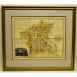

Lot 242
Thomas Dix. Two early nineteenth century county maps of Worcester and Huntingdon divided in Hundreds
Thomas Dix. Two early nineteenth century county maps of Worcester and Huntingdon divided in Hundreds with fold lines. 15in (38cm)x 18.5in (47cm) a...
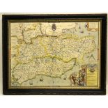
Lot 243
A Saxton coloured map of the South East of England in 1575, framed and glazed. 16in (40.5cm) x 21.
A Saxton coloured map of the South East of England in 1575, framed and glazed. 16in (40.5cm) x 21.75in (55cm).
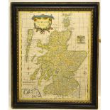
Lot 244
An eighteenth century map of Scotland by Robert Morden, hand coloured 18in (46cm) x 14.25in (
An eighteenth century map of Scotland by Robert Morden, hand coloured 18in (46cm) x 14.25in (36cm), framed and glazed.
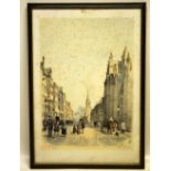
Lot 245
Stone after Maisey a nineteenth century coloured engraving of the High Street, Guildford, 16.5in (
Stone after Maisey a nineteenth century coloured engraving of the High Street, Guildford, 16.5in (42cm) x 11.5in (29cm) (foxed) and J.D. Swarbrech...