
Filtered by:
- Category
- List
- Grid
A subscription to the Price Guide is required to view results for auctions ten days or older. Click here for more information
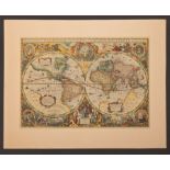

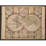
Henricus Hondius II (Dutch, 1597-1651), "Nova Totius Terrarum Orbis Geographica AC Hydrographica
Henricus Hondius II (Dutch, 1597-1651), "Nova Totius Terrarum Orbis Geographica AC Hydrographica Tabula", Amsterdam, 1630, first state, hand-color...

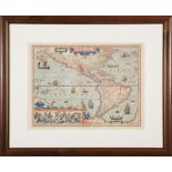
Hendrick Hondius II (Dutch, 1597-1651), "Americae Pars Meridionalis", Amsterdam, 1638, hand-
Hendrick Hondius II (Dutch, 1597-1651), "Americae Pars Meridionalis", Amsterdam, 1638, hand-colored engraved map, from Atlas Novus, elaborate cart...
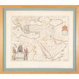
Willem and Joan Blaeu (Dutch, 1571-1638 and 1596-1673), "Turcicum Imperium", Amsterdam, c. 1635,
Willem and Joan Blaeu (Dutch, 1571-1638 and 1596-1673), "Turcicum Imperium", Amsterdam, c. 1635, hand-colored map of the Ottoman Empire, from an e...
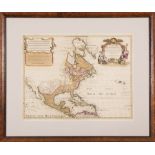
Guillaume de L'Isle and Peter Schenk "L'Amerique Septentrionale Dressee sur les Observations...",
Guillaume de L'Isle and Peter Schenk "L'Amerique Septentrionale Dressee sur les Observations...", Amsterdam, Pierre Schenk, 1708, hand-colored eng...
Jodocus Hondius (1563-1612), "Septentrio America", Amsterdam, 1630, hand-colored engraved map,
Jodocus Hondius (1563-1612), "Septentrio America", Amsterdam, 1630, hand-colored engraved map, from the Mercator atlas, embellished with sea monst...
Matthäeus Seutter (German, 1678-1757), "Diversi Globi Terr-Aquei Statione Variante...", Augsburg, c.
Matthäeus Seutter (German, 1678-1757), "Diversi Globi Terr-Aquei Statione Variante...", Augsburg, c. 1735, hand-colored twin-hemisphere map, incor...
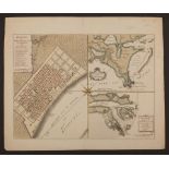
Issak Tirion (Dutch, 1705-1765), "Grondvlakte van Nieuw Orleans, de Hoosdstad van Louisiana...",
Issak Tirion (Dutch, 1705-1765), "Grondvlakte van Nieuw Orleans, de Hoosdstad van Louisiana...", Amsterdam, 1767, 3 hand-colored copper-engraved m...
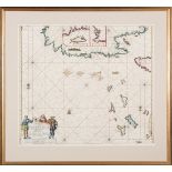
Johannes van Keulen (Dutch, 1654-1715), "Pas kaart van de Noord Kust van Espaniola met d Eylanden
Johannes van Keulen (Dutch, 1654-1715), "Pas kaart van de Noord Kust van Espaniola met d Eylanden daar Benoorden", Amsterdam, 1684, hand-colored e...
Jan Janssonius (1588-1664), "Nova et Accurata Poli Arctici et terrarum Circum iacentium Descriptio",
Jan Janssonius (1588-1664), "Nova et Accurata Poli Arctici et terrarum Circum iacentium Descriptio", Amsterdam, c. 1640, hand-colored map of the p...
Two Hand-Colored Maps , incl. "Typus Orbis Terrarum", c. 1601, from Abraham Orelius' miniature
Two Hand-Colored Maps , incl. "Typus Orbis Terrarum", c. 1601, from Abraham Orelius' miniature atlas, 3 in. x 4 1/4 in.; and "A New Map of ye Nor...
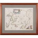
Johannes Blaeu (1596-1673), "Yucatan Conventus luridici Hispaniae Novae Pars Occidentalus, et
Johannes Blaeu (1596-1673), "Yucatan Conventus luridici Hispaniae Novae Pars Occidentalus, et Guatimala Conventus luridicus", Amsterdam, c. 1662, ...
Jacques Nicolas Bellin (French, 1703-1772), two small maps incl., "Carte de la Floride, de la
Jacques Nicolas Bellin (French, 1703-1772), two small maps incl., "Carte de la Floride, de la Louisiane, et Pays Voisins", 1757, 8 5/8 in. x 11 7/...
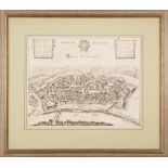
Joannes Janssonius (1588-1664), "Vienna Austriae/Wien in Oostenreyk", Amsterdam, 1682, engraved
Joannes Janssonius (1588-1664), "Vienna Austriae/Wien in Oostenreyk", Amsterdam, 1682, engraved bird's-eye view of Vienna; with a key, in Latin, o...
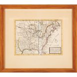
Thomas Jefferys (English, 1719-1717), "The Coast of West Florida and Louisiana/ The Peninsula and
Thomas Jefferys (English, 1719-1717), "The Coast of West Florida and Louisiana/ The Peninsula and Gulf of Florida or Channel of Bahama with the Ba...
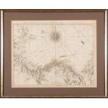
Thomas Jefferys (English, 1719-1771), "The Isthmus of Panama with the Coast from Great River on
Thomas Jefferys (English, 1719-1771), "The Isthmus of Panama with the Coast from Great River on the Moskito Shore to Cartagena", London, Laurie & ...
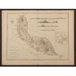
Robert Sayer (English, 1725-1794), "Curacao, from the Original, of Gerard van Keulen, Regulated by
Robert Sayer (English, 1725-1794), "Curacao, from the Original, of Gerard van Keulen, Regulated by Astronomical Obervations", London, 1775, with i...
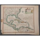
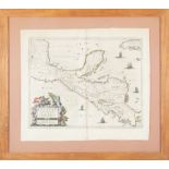
Emanuel Bowen (Welsh, 1694-1767), "Accurate Map of the West Indies...", London, 1747, hand-colored
Emanuel Bowen (Welsh, 1694-1767), "Accurate Map of the West Indies...", London, 1747, hand-colored map, cartouche featuring native Americans and a...
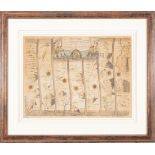
Two John Ogilby Road Maps , "The Road from London to Wells...", and "The Road from Carmarthen
Two John Ogilby Road Maps , "The Road from London to Wells...", and "The Road from Carmarthen to...", London, 1675, engraved strip maps, one hand-...

This item has been removed from the sale. No further information is available. ...[more]

This item has been removed from the sale. No further information is available. ...[more]

This item has been removed from the sale. No further information is available. ...[more]
![[Battle of New Orleans Map] , "Plan of an Attack made by the British Forces on the American Lines in](https://portal-images.azureedge.net/auctions-2020/srne10044/images/5c95a3f1-1c66-4ee5-8cd8-ac22013d7934.jpg?w=155&h=155)
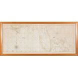
[Battle of New Orleans Map] , "Plan of an Attack made by the British Forces on the American Lines in
[Battle of New Orleans Map] , "Plan of an Attack made by the British Forces on the American Lines in Advance of Orleans on the 8th January 1815", ...

This item has been removed from the sale. No further information is available. ...[more]

This item has been removed from the sale. No further information is available. ...[more]
Group of Twenty-Four Antique Hand-Colored Maps , 17th to 19th c., majority showing provinces of
Group of Twenty-Four Antique Hand-Colored Maps , 17th to 19th c., majority showing provinces of Europe, unframed. Provenance: Property deaccession...