Filtered by:
- Category
- List
- Grid
This auctioneer has chosen to not publish their results. Please contact them directly for any enquiries.
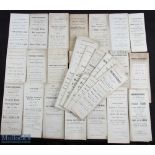

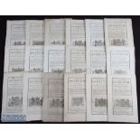
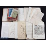
Herefordshire - group of approx. 32 printed sales particulars for properties in Hereford and
Herefordshire - group of approx. 32 printed sales particulars for properties in Hereford and Herefordshire, many including printed maps. Late 19th...
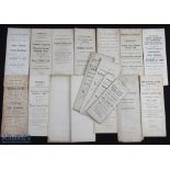
Herefordshire - group of approx. 18 printed sales particulars for properties in Hereford and
Herefordshire - group of approx. 18 printed sales particulars for properties in Hereford and Herefordshire, many including printed maps. Late 19th...
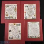
Antique Maps - group of four early 19th century maps by Thomas Moule, of Staffordshire, Shropshire, Worcestershire, and Derbyshire. Each hand colo...
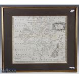
Antique Map - Worcestershire by Robert Morden, late 17th c map of the county, uncoloured, matted
Antique Map - Worcestershire by Robert Morden, late 17th c map of the county, uncoloured, matted framed and glazed. Overall size approx. 590x520mm
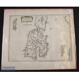
Scotland, The Isle of Islay 1654 - a rare map from Blaeu's Atlas of Scotland, hand coloured in
Scotland, The Isle of Islay 1654 - a rare map from Blaeu's Atlas of Scotland, hand coloured in outline, paper watermarked with the figure of Atlas...
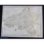
Map of North Wales 1805 - engraved by J Cary and published by John Stockdale, dated 26th March 1805
Map of North Wales 1805 - engraved by J Cary and published by John Stockdale, dated 26th March 1805
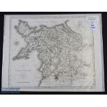
Map of South Wales 1805 - engraved by J Cary and published by John Stockdale, dated 26th March 1805
Map of South Wales 1805 - engraved by J Cary and published by John Stockdale, dated 26th March 1805
Music - 18th C - Twelve Anthems composed by James Kent, organist of the cathedral and college at
Music - 18th C - Twelve Anthems composed by James Kent, organist of the cathedral and college at Winchester, 1773. Engraved title and 100pp music,...
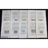
1728-1749 Acts of Parliament a collection of 10 acts with noted items of high treason in Scotland
1728-1749 Acts of Parliament a collection of 10 acts with noted items of high treason in Scotland 1749, Trustees of the Late Lord Widdringtons est...
1746-1756 Acts of Parliament, a collection of 10 acts, with noted items of repair extending of
1746-1756 Acts of Parliament, a collection of 10 acts, with noted items of repair extending of pier at great Yarmouth 1747, church completion Beth...
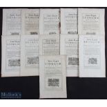
1762-1765 Acts of Parliament, a collection of 20 acts, with noted items of, London Fishermen
1762-1765 Acts of Parliament, a collection of 20 acts, with noted items of, London Fishermen protection, 1762, Westminster Street cleaning and lig...
1772-1779 Acts of Parliament, a collection of 18 acts, with noted items of, Docks in Cornwall and
1772-1779 Acts of Parliament, a collection of 18 acts, with noted items of, Docks in Cornwall and Devon 1782, street cleaning and lighting Edinbur...
c1835 Seaton (Robert) Seaton's Map of Palestine, or the Holy Land, with Part of Egypt, Completed
c1835 Seaton (Robert) Seaton's Map of Palestine, or the Holy Land, with Part of Egypt, Completed from Surveys made for the French & English Govern...
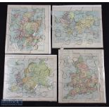
c1880 George Philip & Sons Jigsaw Maps, maps of Europe, England and Wales, Scotland, the world -
c1880 George Philip & Sons Jigsaw Maps, maps of Europe, England and Wales, Scotland, the world -all are complete - size #22cm x 18.5cm ...[more]
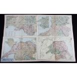
c1898 Bacon Geographical Colour Welsh Wales Maps, to include Monmouth and the River Wye, Wales,
c1898 Bacon Geographical Colour Welsh Wales Maps, to include Monmouth and the River Wye, Wales, Wales central, Wales South - size #50cm x 24cm (4)
1903-1909 Commission on Canals and Waterways England Large Folding Maps, canal systems and navigable
1903-1909 Commission on Canals and Waterways England Large Folding Maps, canal systems and navigable rivers of catchment basins of England, Wales ...
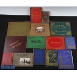
c1860 Souvenir guide of the North, 40 engravings on glazed cards within a tartan slipcase, plus a
c1860 Souvenir guide of the North, 40 engravings on glazed cards within a tartan slipcase, plus a collection of topographical view books, to inclu...
1880-1950 Ordnance Survey Maps OS Maps and other maps most are flat sheets 1" with noted items of
1880-1950 Ordnance Survey Maps OS Maps and other maps most are flat sheets 1" with noted items of Helstone, Walsall, Northallerton, Portsmouth, Br...
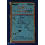
The ABC Air Guide Oct - Nov 1946 - Aviation Guide - very comprehensive just Post-War Civil Aviation Guide of some 300 pages plus fold out Europe a...
United States of America - Prairie Experiences in Handling Cattle and Sheep by Major W Shepherd,
United States of America - Prairie Experiences in Handling Cattle and Sheep by Major W Shepherd, 1884 - 256 page book with 8 full page illustratio...
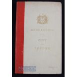
World War II - Reconstruction in The City of London 1944 - subtitled "Report Improvements and Town
World War II - Reconstruction in The City of London 1944 - subtitled "Report Improvements and Town Planning Committee on the Preliminary Draft Pro...
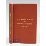
Somerset - Rail & Road Tourist Guide by R N Worth 1890 - An extensive 168 page Tourist Guide listing
Somerset - Rail & Road Tourist Guide by R N Worth 1890 - An extensive 168 page Tourist Guide listing some 300 places to visit and see, has fold ou...
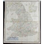
Wyld's Map of England & Wales (Scotland in Insert) Published 1838 - It's entitled; "A map of
Wyld's Map of England & Wales (Scotland in Insert) Published 1838 - It's entitled; "A map of England, Wales & Scotland, describing all the direct ...
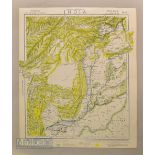
1881 Letts Popular Atlas India / Punjab colour map. Sheet No 12 covering Punjab, Baluchistan,
1881 Letts Popular Atlas India / Punjab colour map. Sheet No 12 covering Punjab, Baluchistan, Afghanistan extending to Kandahar, Kabul, Peshawar, ...
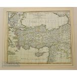
1821 Turkey Map by Richards Holmes Laurie, Asia Qua Vulgo Dicatur Et Syria map after D'Anvill
1821 Turkey Map by Richards Holmes Laurie, Asia Qua Vulgo Dicatur Et Syria map after D'Anvill 1764, Shows Turkey and surrounding states including ...