Filtered by:
- Category,
- Item Type
- List
- Grid
This auctioneer has chosen to not publish their results. Please contact them directly for any enquiries.
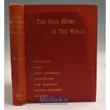

The Gold Mines Of The World by J.H. Curle 1899 Book - First Edition. Large book with maps and
The Gold Mines Of The World by J.H. Curle 1899 Book - First Edition. Large book with maps and photographs of Mines in Transvaal^ India^ West Austr...
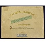
Bon Marche (Leading Store in Paris^ still exists)^ 1914 Furniture Catalogue A most attractive 40
Bon Marche (Leading Store in Paris^ still exists)^ 1914 Furniture Catalogue A most attractive 40 page furniture catalogue showing each item of fur...
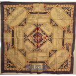
British Empire Exhibition^ 1924 - Large Colourful Printed Cloth illustrating 15 of the largest
British Empire Exhibition^ 1924 - Large Colourful Printed Cloth illustrating 15 of the largest Pavilions at the Exhibition as well as the boating ...
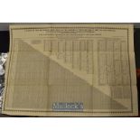
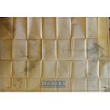
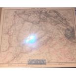
Table of the reciprocal Distances of the Principal Towns of Great Britain and Ireland published
Table of the reciprocal Distances of the Principal Towns of Great Britain and Ireland published Leeds at The Mercury Office by Edward Baines^ with...
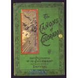
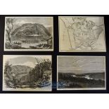
The Canyons Of Colorado Circa 1890s Souvenir Album A fold out Souvenir Views Album of 16 photograph on thick card of the Canyons mostly also showi...
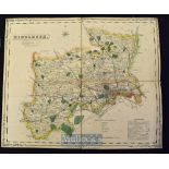
Folding Map of The County of Middlesex. Publisher: H.G. Collins^ Paternoster Row^ London Circa 1850s
Folding Map of The County of Middlesex. Publisher: H.G. Collins^ Paternoster Row^ London Circa 1850s Fine Hand coloured map cut into sections and...
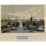
China - 1843 Entrance of the Hoang-ho^ or Yellow River colour engraving drawn by T. Allom measures
China - 1843 Entrance of the Hoang-ho^ or Yellow River colour engraving drawn by T. Allom measures 25x20cm approx
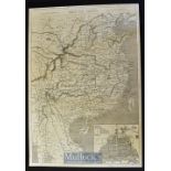
China - Map of China with plan of Canton large original double page map showing all principle cities
China - Map of China with plan of Canton large original double page map showing all principle cities and towns from Mongolia to Siam from a Britis...
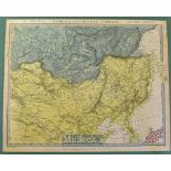
China - Coloured Map of Siberia and Chinese Tartary by Piadisehev-J. Arrowsmith published by the
China - Coloured Map of Siberia and Chinese Tartary by Piadisehev-J. Arrowsmith published by the Society for the Diffusion of Useful Knowledge 15t...
New Zealand - The War in New Zealand original woodblock prints from the Illustrated London News to
New Zealand - The War in New Zealand original woodblock prints from the Illustrated London News to include 12x prints depicting Large Meeting of S...
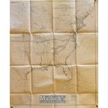
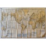
USA Maps - US Coast and Geodetic Survey Sketch of General Progress 30 June 1900^ 2 map^ Eastern
USA Maps - US Coast and Geodetic Survey Sketch of General Progress 30 June 1900^ 2 map^ Eastern and Western 32.5"x27" each^ folded (2)
USA Map - Oblique Boundary Between California and Nevada - Lake Tahac to Colorado Rivers with
USA Map - Oblique Boundary Between California and Nevada - Lake Tahac to Colorado Rivers with eight sketch maps published in the Coast and Geodeti...
Alaska Map - Exploration in Alaska 1899 topography by W.J. Peters 1 to 10 miles 49"x32.75" plus
Alaska Map - Exploration in Alaska 1899 topography by W.J. Peters 1 to 10 miles 49"x32.75" plus margins. Shows the Yukon and Alaska Boundary^ the ...
Shipping - Map Tracks for Full Powered Steam Vessels - Department of the Navy-Bureau of Navigation
Shipping - Map Tracks for Full Powered Steam Vessels - Department of the Navy-Bureau of Navigation USA drawn by AC Roberts and G. Noetzel^ publish...
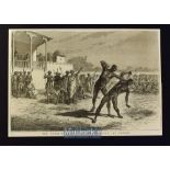
India - The Nucki-Ka-Koosti or Boxing Match at Baroda original engraving 1875 24x17cm laid to card
India - The Nucki-Ka-Koosti or Boxing Match at Baroda original engraving 1875 24x17cm laid to card
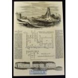
India - The Ancient and Ruined City of Brahmunabad in Sind original full page with illustrations and
India - The Ancient and Ruined City of Brahmunabad in Sind original full page with illustrations and text Feb 1857 37x25cm laid to card
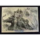
India - Nepal - The Prince of Wales Elephant Charged by a Tiger original double page engraving
India - Nepal - The Prince of Wales Elephant Charged by a Tiger original double page engraving 1876 after W. Simpson 50x34cm laid to card
India - Tombs of the Gond Rajahs^ Chanda^ Central India original engraving 1875 32x23cm laid to
India - Tombs of the Gond Rajahs^ Chanda^ Central India original engraving 1875 32x23cm laid to card
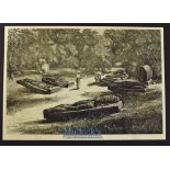
India - Calcutta - Three 19th Century views of Calcutta to include Fort William sketched from the
India - Calcutta - Three 19th Century views of Calcutta to include Fort William sketched from the river 1857 25x15cm^ The Harbour 1857 from a Fren...
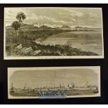
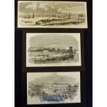
India - Bombay - Two 19th Century view of Bombay to include General View of Bombay from Malabar Hill
India - Bombay - Two 19th Century view of Bombay to include General View of Bombay from Malabar Hill 1853 36x19cm^ Harbour of Bombay 1857 33x11cm ...
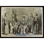
India - The Princes of Oude and Suite original engraving 1857 shows the eldest son and heir to the
India - The Princes of Oude and Suite original engraving 1857 shows the eldest son and heir to the deposed King of Oude The General brother to the...
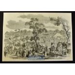
India - A Hindoo Fair original engraving 1858 probably after W. Carpenter 36x25cm laid to card
India - A Hindoo Fair original engraving 1858 probably after W. Carpenter 36x25cm laid to card with descriptive text in reverse
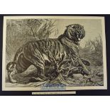
India - Le Roi Des Jungles (King of the Jungle) original engraving after painting by Bouverie
India - Le Roi Des Jungles (King of the Jungle) original engraving after painting by Bouverie Goddard 50x33cm published in L'Univers Illustre 1880...
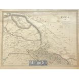
India - Early Map of Maharaja Ranjit Singhs dominions - Showing the boundaries of the Sikh empire
India - Early Map of Maharaja Ranjit Singhs dominions - Showing the boundaries of the Sikh empire which include cashmere^ also the British protect...
Lander des Pendschab - Land of Punjab map - Rare original post Anglo Sikh wars map showing Maharajas
Lander des Pendschab - Land of Punjab map - Rare original post Anglo Sikh wars map showing Maharajas Gulab Singhs newly acquired Kashmir state und...