Filtered by:
- Category,
- Item Type
- List
- Grid
This auctioneer has chosen to not publish their results. Please contact them directly for any enquiries.


Take That Music Poster measures 59x90cm, plus Take That Nobody Else measures 48x66cm, Robbie
Take That Music Poster measures 59x90cm, plus Take That Nobody Else measures 48x66cm, Robbie Williams 64x90cm and Mark Owen 60x84cm - varying cond...

Manuel Benitez Pérez ‘El Cordobés’ Matador Poster and Matador Hat the poster 1970 in colour,
Manuel Benitez Pérez ‘El Cordobés’ Matador Poster and Matador Hat the poster 1970 in colour, advertising in Mallorca, ‘Paco Camino The Great Hamis...
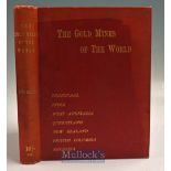
The Gold Mines Of The World by J.H. Curle 1899 Book - First Edition. Large book with maps and
The Gold Mines Of The World by J.H. Curle 1899 Book - First Edition. Large book with maps and photographs of Mines in Transvaal, India, West Austr...

Morgan - The World’s Leading 3 Wheeler Circa 1937 Sales Catalogue - A 4 page sales catalogue
Morgan - The World’s Leading 3 Wheeler Circa 1937 Sales Catalogue - A 4 page sales catalogue illustrating their Model “F-4” for £270 and their Mod...
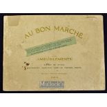
Bon Marche (Leading Store in Paris, still exists), 1914 Furniture Catalogue A most attractive 40
Bon Marche (Leading Store in Paris, still exists), 1914 Furniture Catalogue A most attractive 40 page furniture catalogue showing each item of fur...
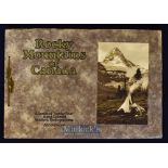
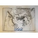
Rocky Mountains of Canada 1920s Publication - Has 24 large tipped in full page hand tinted scenic
Rocky Mountains of Canada 1920s Publication - Has 24 large tipped in full page hand tinted scenic views of the Transcontinental Railway, Mountains...
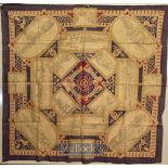
British Empire Exhibition, 1924 - Large Colourful Printed Cloth illustrating 15 of the largest
British Empire Exhibition, 1924 - Large Colourful Printed Cloth illustrating 15 of the largest Pavilions at the Exhibition as well as the boating ...
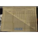
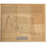
Table of the reciprocal Distances of the Principal Towns of Great Britain and Ireland published
Table of the reciprocal Distances of the Principal Towns of Great Britain and Ireland published Leeds at The Mercury Office by Edward Baines, with...
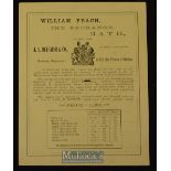
William Peach, The Exchange, Bath Ale Brewers Broadside 1880s Agent in Bath for the sale of the
William Peach, The Exchange, Bath Ale Brewers Broadside 1880s Agent in Bath for the sale of the celebrated Ales brewed by Messrs J.A. Devenish & C...
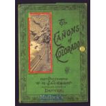
The Canyons Of Colorado Circa 1890s Souvenir Album A fold out Souvenir Views Album of 16 photograph on thick card of the Canyons mostly also showi...
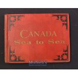
Canada - ‘Canada From Sea To Sea’ by G. Mercer Adam Toronto 1888 Picture Book A largely Tourist
Canada - ‘Canada From Sea To Sea’ by G. Mercer Adam Toronto 1888 Picture Book A largely Tourist picture book with 56 full page views of places acr...
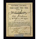
Festiniog Railway “Free Pass” 1911 Made out to Mr. A. Adams, J.B. Saunders and a boy. 3rd Class Free
Festiniog Railway “Free Pass” 1911 Made out to Mr. A. Adams, J.B. Saunders and a boy. 3rd Class Free Pass. Detailed black printing with hand signa...
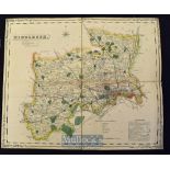
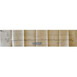
Folding Map of The County of Middlesex. Publisher: H.G. Collins, Paternoster Row, London Circa 1850s
Folding Map of The County of Middlesex. Publisher: H.G. Collins, Paternoster Row, London Circa 1850s Fine Hand coloured map cut into sections and...
Various Maps of Europe, engraved by Ch. Dyonet, in various sizes, circa 1880, worth inspecting (22)
Various Maps of Europe, engraved by Ch. Dyonet, in various sizes, circa 1880, worth inspecting (22)
Americana – Map of Livingston Manor Anno 1714 by John Beatty Dep Survivor, measures 28x24cm,
Americana – Map of Livingston Manor Anno 1714 by John Beatty Dep Survivor, measures 28x24cm, sheet, previously folded, foxed in places
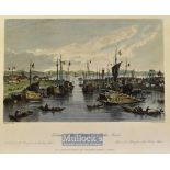
China - 1843 Entrance of the Hoang-ho, or Yellow River colour engraving drawn by T. Allom measures
China - 1843 Entrance of the Hoang-ho, or Yellow River colour engraving drawn by T. Allom measures 25x20cm approx
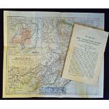
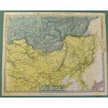
China – Map of Manchuria – compiled from the latest Russian Documents and Information supplied by
China – Map of Manchuria – compiled from the latest Russian Documents and Information supplied by H.E.M James published for Royal Geographical Soc...
China - Antique hand drawn and coloured Map of China shows Hong Kong Island as British but not
China - Antique hand drawn and coloured Map of China shows Hong Kong Island as British but not Kowloon, hence 1841-1860 possibly a draft a book or...
China - Map of China with plan of Canton large original double page map showing all principle cities
China - Map of China with plan of Canton large original double page map showing all principle cities and towns from Mongolia to Siam from a Britis...
China - Coloured Map of Siberia and Chinese Tartary by Piadisehev-J. Arrowsmith published by the
China - Coloured Map of Siberia and Chinese Tartary by Piadisehev-J. Arrowsmith published by the Society for the Diffusion of Useful Knowledge 15t...
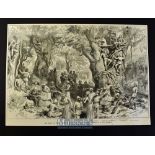
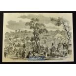
New Zealand - The War in New Zealand original woodblock prints from the Illustrated London News to
New Zealand - The War in New Zealand original woodblock prints from the Illustrated London News to include 12x prints depicting Large Meeting of S...
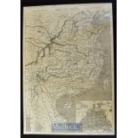
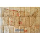
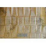
USA Maps - US Coast and Geodetic Survey Sketch of General Progress 30 June 1900, 2 map, Eastern
USA Maps - US Coast and Geodetic Survey Sketch of General Progress 30 June 1900, 2 map, Eastern and Western 32.5"x27" each, folded (2)
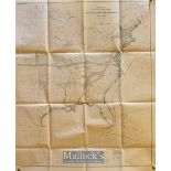
USA Map - Map showing the Location of the Indian Reservations Within the Limits of the United States
USA Map - Map showing the Location of the Indian Reservations Within the Limits of the United States and Territories compiled from official and ot...
USA Map - Oblique Boundary Between California and Nevada - Lake Tahac to Colorado Rivers with
USA Map - Oblique Boundary Between California and Nevada - Lake Tahac to Colorado Rivers with eight sketch maps published in the Coast and Geodeti...
Alaska Map - Exploration in Alaska 1899 topography by W.J. Peters 1 to 10 miles 49"x32.75" plus
Alaska Map - Exploration in Alaska 1899 topography by W.J. Peters 1 to 10 miles 49"x32.75" plus margins. Shows the Yukon and Alaska Boundary, the ...
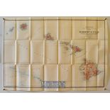
USA - Hawaii - Map of the Territory of Hawaii compiled from various sources by I.P Berthrong 1905 1"
USA - Hawaii - Map of the Territory of Hawaii compiled from various sources by I.P Berthrong 1905 1" to 12 miles, 33"x22", folded, splits to fold ...
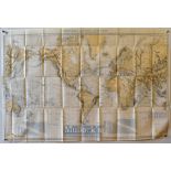
Shipping - Map Tracks for Full Powered Steam Vessels - Department of the Navy-Bureau of Navigation
Shipping - Map Tracks for Full Powered Steam Vessels - Department of the Navy-Bureau of Navigation USA drawn by AC Roberts and G. Noetzel, publish...
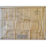
West Indies - Chart of The West Indies with Adjacent Coast of South America showing the Tracks of
West Indies - Chart of The West Indies with Adjacent Coast of South America showing the Tracks of Don Christopher Columbus by J&C Walker, publishe...
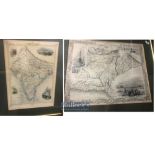
India & Punjab – Antique Maps of Punjab Two hand coloured engraved mid 19th century maps of North
India & Punjab – Antique Maps of Punjab Two hand coloured engraved mid 19th century maps of North India from the 1850s, one titled ‘Cabool, The Pu...
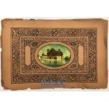
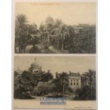
India & Punjab – Golden Temple Print a vintage antique print of a mounted images of the Golden
India & Punjab – Golden Temple Print a vintage antique print of a mounted images of the Golden Temple of Amritsar on an elaborate stone print page...

India - The Nucki-Ka-Koosti or Boxing Match at Baroda original engraving 1875 24x17cm laid to card
India - The Nucki-Ka-Koosti or Boxing Match at Baroda original engraving 1875 24x17cm laid to card
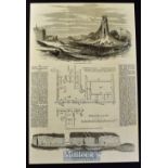
India - The Ancient and Ruined City of Brahmunabad in Sind original full page with illustrations and
India - The Ancient and Ruined City of Brahmunabad in Sind original full page with illustrations and text Feb 1857 37x25cm laid to card
India - Arrival of the Prince of Wales at Agra original double page engraving 1876 after W. Simpson 52x36cm laid to card
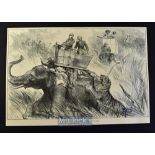
India - Nepal - The Prince of Wales Elephant Charged by a Tiger original double page engraving
India - Nepal - The Prince of Wales Elephant Charged by a Tiger original double page engraving 1876 after W. Simpson 50x34cm laid to card
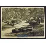
India - Nepal - The Prince of Wales Tiffin in the Nepal Terai original double page engraving 1876
India - Nepal - The Prince of Wales Tiffin in the Nepal Terai original double page engraving 1876 after a drawing by W. Simpson 48x34cm laid to ca...
India - Tombs of the Gond Rajahs, Chanda, Central India original engraving 1875 32x23cm laid to
India - Tombs of the Gond Rajahs, Chanda, Central India original engraving 1875 32x23cm laid to card
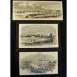
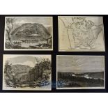
India - Calcutta - Three 19th Century views of Calcutta to include Fort William sketched from the
India - Calcutta - Three 19th Century views of Calcutta to include Fort William sketched from the river 1857 25x15cm, The Harbour 1857 from a Fren...
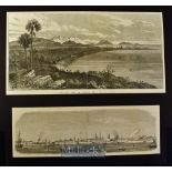
India - Bombay - Two 19th Century view of Bombay to include General View of Bombay from Malabar Hill
India - Bombay - Two 19th Century view of Bombay to include General View of Bombay from Malabar Hill 1853 36x19cm, Harbour of Bombay 1857 33x11cm ...
India - Map Showing the English Territory the Native States and Presidency's from a book published
India - Map Showing the English Territory the Native States and Presidency's from a book published in America and dated 1858 36x28cm laid to card
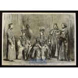
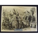
India - The Princes of Oude and Suite original engraving 1857 shows the eldest son and heir to the
India - The Princes of Oude and Suite original engraving 1857 shows the eldest son and heir to the deposed King of Oude The General brother to the...
India - A Hindoo Fair original engraving 1858 probably after W. Carpenter 36x25cm laid to card
India - A Hindoo Fair original engraving 1858 probably after W. Carpenter 36x25cm laid to card with descriptive text in reverse
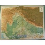
India – 1905 Map of North Western Section centred on the Punjab and Oude published by John Bartholomew & Co for the Times Atlas 1905 55x43cm on ca...
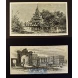
India - Calcutta - Four views of Calcutta 1875 to include Great Mosque at Hooghly, Government
India - Calcutta - Four views of Calcutta 1875 to include Great Mosque at Hooghly, Government House South Eastern Arch and South Front and Eden Ga...
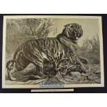
India - Le Roi Des Jungles (King of the Jungle) original engraving after painting by Bouverie
India - Le Roi Des Jungles (King of the Jungle) original engraving after painting by Bouverie Goddard 50x33cm published in L'Univers Illustre 1880...
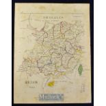
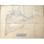
India & Punjab - Map of the Punjab and the Sikh Provence of Mooltan by Major Herbert B Edwards to
India & Punjab - Map of the Punjab and the Sikh Provence of Mooltan by Major Herbert B Edwards to illustrate a year on the Punjab frontier. Mounte...
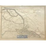
India - Early Map of Maharaja Ranjit Singhs dominions - Showing the boundaries of the Sikh empire
India - Early Map of Maharaja Ranjit Singhs dominions - Showing the boundaries of the Sikh empire which include cashmere, also the British protect...
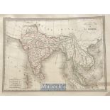
Map of the India & the Chinese Empire steel engraved and hand coloured. c1846 Dimensions: 39 x 29.
Map of the India & the Chinese Empire steel engraved and hand coloured. c1846 Dimensions: 39 x 29.5 cm ...[more]
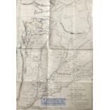
India & Punjab - C1856 Rare large post Sikh wars outline Map of the Punjab by Lt col R Napier -
India & Punjab - C1856 Rare large post Sikh wars outline Map of the Punjab by Lt col R Napier - Showing the transferral of Sikh occupied Cashmere ...
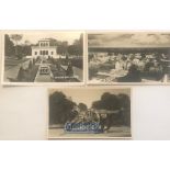
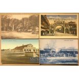
India – Topographical postcards (3) views of the Lahore, Punjab. Including Ranjit Singhs Hazuri
India – Topographical postcards (3) views of the Lahore, Punjab. Including Ranjit Singhs Hazuri Bagh, Zam Zam cannon & bird eye view of city. c19...
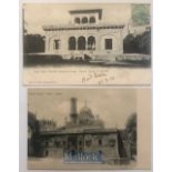
India – Topographical postcards (2) views of the Maharaja Ranjit Singhs tomb or Samadhi Lahore,
India – Topographical postcards (2) views of the Maharaja Ranjit Singhs tomb or Samadhi Lahore, Punjab. c1900s
India – Topographical postcards (2) views of the Lahore, Punjab. Including Ranjit Singhs Samadhi &
India – Topographical postcards (2) views of the Lahore, Punjab. Including Ranjit Singhs Samadhi & Hazuri Bagh summer palace c1900s. ...[more]
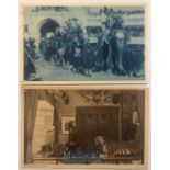
India & Punjab - Original postcards (2) views of the Patiala, Punjab. Including Maharaja of Patiala on elephants & state court c1900s ...[more]
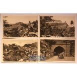
India - Original set of 14x postcards of Simla, India by Thacker Spink & co views include library,
India - Original set of 14x postcards of Simla, India by Thacker Spink & co views include library, mall, bazaar, hospital, Snowdon, wildflower hal...
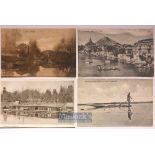
India - Collection of 20x postcards views of Kashmir, India - View include nishat bagh, liddar
India - Collection of 20x postcards views of Kashmir, India - View include nishat bagh, liddar valley, the city, Srinagar, Jhelum river, wool at l...
India - Collection of 12x postcards views of northern India by Bremner. Views include sind, Murree, Kashmir, Quetta, Karachi plus others. All c190...
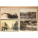
India - Collection of 12x real photo postcards of Peshawar. Views include bazaar, fort, Jalalabad,
India - Collection of 12x real photo postcards of Peshawar. Views include bazaar, fort, Jalalabad, government house, Peshawar city, main mosque pl...
India - Collection of 12x real photo postcards of Peshawar - Views include bazaar, fort, Peshawar
India - Collection of 12x real photo postcards of Peshawar - Views include bazaar, fort, Peshawar city, soldiers’ bungalow, kabli gate, suddar baz...
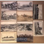
India - Collection of 10x postcards of Rawalpindi - Views include city bazaar, messi gate, Barracks,
India - Collection of 10x postcards of Rawalpindi - Views include city bazaar, messi gate, Barracks, station, the club plus others. All c1900s

Lander des Pendschab - Land of Punjab map - Rare original post Anglo Sikh wars map showing Maharajas
Lander des Pendschab - Land of Punjab map - Rare original post Anglo Sikh wars map showing Maharajas Gulab Singhs newly acquired Kashmir state und...
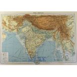
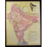
Selection of Maps of India to include The Bengal Presidency, North India, South India, plus Asia,
Selection of Maps of India to include The Bengal Presidency, North India, South India, plus Asia, examples by Rapkin, Becker, Philip, Steiler et a...