Filtered by:
- Category,
- Item Type
- List
- Grid
This auctioneer has chosen to not publish their results. Please contact them directly for any enquiries.
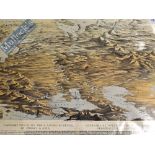

Scarce and Early Map of Russia - Birds eye, panoramic view of the whole empire of Russia in Europe &
Scarce and Early Map of Russia - Birds eye, panoramic view of the whole empire of Russia in Europe & Asia published in London 1855, this map shows...
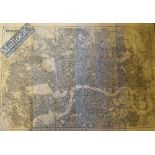
1900 Map of London – printed for the Post Office Directory, uncoloured, measures 109cmx300cm approx.
1900 Map of London – printed for the Post Office Directory, uncoloured, measures 109cmx300cm approx. laid on linen, overall condition appears A/G
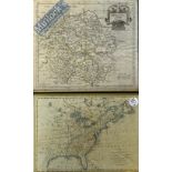
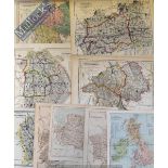
17th Century Robert Morden Map of Herefordshire 63 x 49cm together with later example of United
17th Century Robert Morden Map of Herefordshire 63 x 49cm together with later example of United States of North America by T Bowen 48 x 35cm both ...
Selection of 18th Century Maps To include 1818 map of Wales by C Smith, Black’s Travelling map of
Selection of 18th Century Maps To include 1818 map of Wales by C Smith, Black’s Travelling map of England, Cruchley’s Cornwall, Humphrey’s North W...
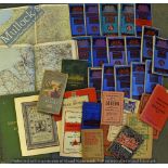
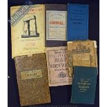
Collection of Various Maps Consisting of Bartholomew’s Half Inch, Harmsworth Atlas Motor Maps (Box)
Collection of Various Maps Consisting of Bartholomew’s Half Inch, Harmsworth Atlas Motor Maps (Box)
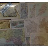
Selection of Maps Mostly have been removed from an atlas together with 2 framed examples covering
Selection of Maps Mostly have been removed from an atlas together with 2 framed examples covering the UK (Box)
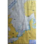
Admiralty Chart Signed Large Chart / Map of the North Sea used by Cunard Queen Victoria 1st August
Admiralty Chart Signed Large Chart / Map of the North Sea used by Cunard Queen Victoria 1st August to 15th August 2010 Southampton to Southampton ...
Collection of English County Maps Covering most counties all have been removed from an atlas (20)
Collection of English County Maps Covering most counties all have been removed from an atlas (20)
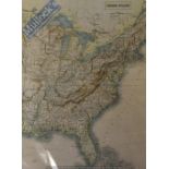
19th Century Maps of United States of North America 63 x 43cm together with United States 49 x
19th Century Maps of United States of North America 63 x 43cm together with United States 49 x 37cm ready for framing (2)
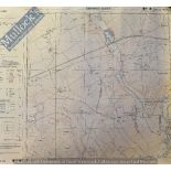
Maps – Selection of Southampton Based Ordnance Survey Maps featuring Bitterne, Peartree Avenue, Bath
Maps – Selection of Southampton Based Ordnance Survey Maps featuring Bitterne, Peartree Avenue, Bath Road, Bursledon Road, Weston Parade, West End...
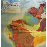
Australia Map - Large Tectonic Map of Australia 1960 paper back on linen, in colour, cartographer W.
Australia Map - Large Tectonic Map of Australia 1960 paper back on linen, in colour, cartographer W. J. Buckridge, measures 160cmx160cm approx., m...
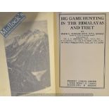
Big Game Hunting in the Himalayas and Tibet Book by Major G. Burrard, London 1925 1st Ed, 24
Big Game Hunting in the Himalayas and Tibet Book by Major G. Burrard, London 1925 1st Ed, 24 illustrations and 8 Maps in original blue cloth bindi...
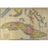
Cuba – Map of Cuba, it’s Provinces, Railroads, Cities, Towns, Harbours, Bays etc. – by Mast Crowell and Kirkpatrick, in colour, measures 51x35cm a...
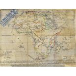
Africa – Map ‘L’Afrique En 1840’ with coloured borders, D.A. Houzé, measures31x24cm approx. light
Africa – Map ‘L’Afrique En 1840’ with coloured borders, D.A. Houzé, measures31x24cm approx. light folds, o/w a good example
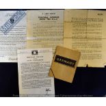
WWII – British Servicemen in Germany Booklet entitled ‘Germany’ published in 1944 and deals with
WWII – British Servicemen in Germany Booklet entitled ‘Germany’ published in 1944 and deals with life in Germany and with the way you should behav...

Our Men in Korea - by Eric Linklater 1952 Publication - A 79 page publication with over 40 photographs and several maps giving an interesting acco...

Oxfordshire Cloth Backed Map - Publisher: H.G. Collins, 22 Paternoster Row, London, 1855: fine
Oxfordshire Cloth Backed Map - Publisher: H.G. Collins, 22 Paternoster Row, London, 1855: fine Hand coloured map cut into sections and pasted to c...
India & Punjab – The Tomb of Runjeet Singh Founder of the Sikh Empire (Lahore) original engraving
India & Punjab – The Tomb of Runjeet Singh Founder of the Sikh Empire (Lahore) original engraving 1872 measures 22x20cm approx., mounted ...[more]
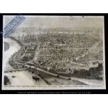
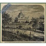
India – The City of Delhi Before the Siege Original Print 1858 of a birdseye view of the city
India – The City of Delhi Before the Siege Original Print 1858 of a birdseye view of the city listing principle locations, measures 35x35cm approx...