
Refine your search
Filtered by:
- Category,
- Creator / Brand
- List
- Grid
This auctioneer has chosen to not publish their results. Please contact them directly for any enquiries.


1926 Award to Garda by Dublin Society for the Prevention of Cruelty to Animals. An honorary testimonial of the Society, for preventing acts of cru...
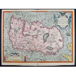
1573 Map of Ireland by Ortelius. A hand-coloured, engraved map, Eyrn Hiberniae, Britannicae, Insulae Nova Descripto, Irlandt, orientated to the We...
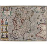
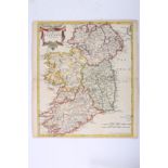
1610-11 Map of Ireland by John Speed, a hand-coloured, engraved map, The Kingdom of Ireland,
1610-11 Map of Ireland by John Speed, a hand-coloured, engraved map, The Kingdom of Ireland, John Sudbury and George Humble, first edition, Englis...
1636 Map of the southern half of Ireland by Mercator and 1759 Plans of the Principal Ports, Towns and Harbours of Ireland, for Mr Tindall's Conti...
1654 Map of Ireland by Blaeu.
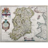
1654 Map of Ireland by Blaeu. A hand-coloured, engraved map, Hiberno Regnum Vulgo Ireland in the first state as published in the 1654 fifth volume...
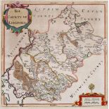
1685 Map of Longford by William Petty. A hand-coloured, engraved map, The County of Longford, 11¼" x 11" (28.5 x 28cm), mounted.
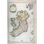
1695 The Kingdom of Ireland, by Robert Morden. A hand-coloured, engraved map, from Camden's Britannia, 1695, with Newry spelt 'Nury', reverse blan...
1750s Chart of Ireland by Jacques Nicolas Bellin. A hand-coloured, engraved chart, Carte Reduite des Isles Britanniques. Cinquieme Feuille Contena...
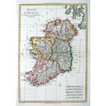
1766 Map of Ireland by Rigobert Bonne. A hand-coloured, engraved map Royaume D'Irlande, 14" x 9½" (35.5 x 24cm) loose.
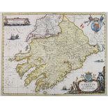
1676 Map of Munster by Schenk & Valk. A hand-coloured, engraved map, after Jansson Provincia Momonia - The Province of Mounster, 15" x 19" (38 x 4...
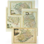
1787 Maps of the four Provinces of Ireland by Alexander Hogg. A set of four hand-coloured, engraved maps, New and Correct Map(s) of the Province(s...
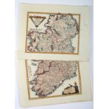
1789 Map of Ireland by Franz von Reilly. A pair of hand-coloured, engraved maps Das Konigreich Ireland.., showing Ireland North and South, 9" x 11...
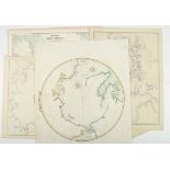
1822-1872 Collection of Maps of Polar Regions. Five maps by various publishers, including A Constable, Edinburgh, 1822; The Weekly Dispatch Atlas,...
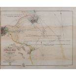
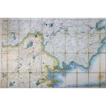
1828-1842 Chart of Dublin Bay.
1828-1842 Chart of Dublin Bay. A hand-coloured, engraved chart by Mudge and Frazer, Survey of Dublin Bay and the Adjacent Banks, with revisions 18...
Early 1840s Map of Ireland With All the Railways. A hand-coloured, engraved map, in two sheets, showing the existing railways, those in developmen...
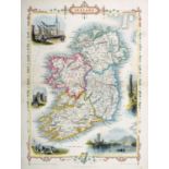
1851 Map of Ireland by John Tallis. A hand-coloured engraved map of Ireland with vignettes of St Patrick's Dublin, Limerick Castle, The Holy Well,...
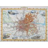
1851 Plan of Dublin by John Tallis. A hand-coloured engraved map of the city between the canals with vignettes of some of the principle buildings....
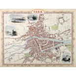
1851 Plan of Cork by John Tallis. A hand coloured, engraved plan of the City of Cork, inset vignettes of Blarney and Blackrock Castles, Queenstown...
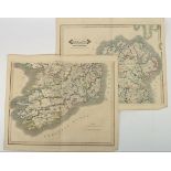
1899 Ordnance Survey, Counties Clare and Galway, original colour, sectioned and linen backed,
1899 Ordnance Survey, Counties Clare and Galway, original colour, sectioned and linen backed, marbled retailer's boards for Sifton, Praed & Co. Lo...
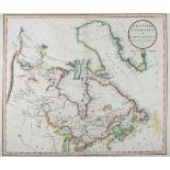
1811 British Colonies in North America. A hand-coloured, engraved map, British Colonies in North America, Drawn from the Best Authorities; by John...