Filtered by:
- Category,
- Item Type
- List
- Grid
A subscription to the Price Guide is required to view results for auctions ten days or older. Click here for more information


JOHANNES BLAEU (Dutch 1596-1673) Eborasensis, hand coloured and engraved map, double page, 39.5cm
JOHANNES BLAEU (Dutch 1596-1673) Eborasensis, hand coloured and engraved map, double page, 39.5cm x 51.5cm. See illustration
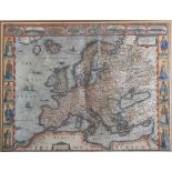
JOHN SPEED (1552-1629) THE DESCRIPTION OF EUROPE, hand coloured and engraved map 1626, bordered by
JOHN SPEED (1552-1629) THE DESCRIPTION OF EUROPE, hand coloured and engraved map 1626, bordered by vignettes of the chief cities and portraits rep...
JOHN SPEEDE (1552-1629) The Bishopric and Citie of Durham, 1611, hand coloured engraved map,
JOHN SPEEDE (1552-1629) The Bishopric and Citie of Durham, 1611, hand coloured engraved map, double page, 39cm x 51cm
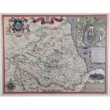
JOHN SPEEDE (1552-1629) The Countie Westmorland and Kendal The Cheif Towne Described, 1611-1631,
JOHN SPEEDE (1552-1629) The Countie Westmorland and Kendal The Cheif Towne Described, 1611-1631, hand coloured engraved map, double page, 39cm x 5...
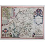
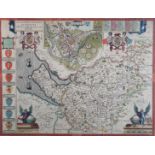
JOHN SPEEDE (c.1552-1629) Darbieshire Described 1610, hand coloured engraved map, double page,
JOHN SPEEDE (c.1552-1629) Darbieshire Described 1610, hand coloured engraved map, double page, 39cm x 51.5cm
JOHN SPEEDE (1552-1629) The County Palatine of Chester 17th century hand coloured engraved map,
JOHN SPEEDE (1552-1629) The County Palatine of Chester 17th century hand coloured engraved map, double page, 39cm x 51cm
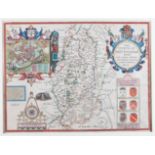
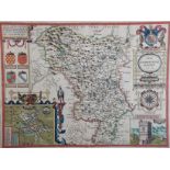
JOHN SPEEDE (1552-1629) The Countie of Nottingham, hand coloured engraved map, double page, 39cm x
JOHN SPEEDE (1552-1629) The Countie of Nottingham, hand coloured engraved map, double page, 39cm x 51.5cm, unframed
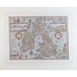
JOHN SPEEDE (1552-1629) The Kingdome of Great Britain and Ireland, hand coloured engraved map,
JOHN SPEEDE (1552-1629) The Kingdome of Great Britain and Ireland, hand coloured engraved map, double page, 39cm x 52.5cm; together with The Kingd...

CAMDENS BRITANNIA 1607 - Christopherus Saxton map of Northumbriae, hand coloured engraved plate,
CAMDENS BRITANNIA 1607 - Christopherus Saxton map of Northumbriae, hand coloured engraved plate, 30cm x 31cm, framed