Filtered by:
- Category
- List
- Grid
A subscription to the Price Guide is required to view results for auctions ten days or older. Click here for more information
![Admiral Lord Nelson. School Atlas; or, Key to Goldsmith's Geographical Copy-Books [...], London:](https://portal-images.azureedge.net/auctions-2024/srmel10225/images/b6a6827d-24ef-4995-b1ed-b1000108d6d4.jpg?h=210)

Admiral Lord Nelson. School Atlas; or, Key to Goldsmith's Geographical Copy-Books [...], London:
Admiral Lord Nelson. School Atlas; or, Key to Goldsmith's Geographical Copy-Books [...], London:Printed for Richard Phillips, n.d. [inscription da...
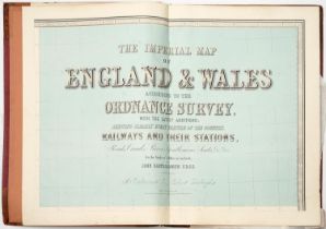
Atlas. John Bartholomew FRGS (1831-1893) - The Imperial Map of England & Wales according to the
Atlas. John Bartholomew FRGS (1831-1893) - The Imperial Map of England & Wales according to the Ordnance Survey [...], On the Scale of 4 Miles to ...
![Binding. [Lubin (Eilhard)], Clavis Graecæ linguæ, [Amsterdam]: [Jan Janssonius], [1647], defective](https://portal-images.azureedge.net/auctions-2024/srmel10225/images/d6d0b0b3-5968-49e9-a48d-b10001084e48.jpg?h=210)
Binding. [Lubin (Eilhard)], Clavis Graecæ linguæ, [Amsterdam]: [Jan Janssonius], [1647], defective
Binding. [Lubin (Eilhard)], Clavis Graecæ linguæ, [Amsterdam]: [Jan Janssonius], [1647], defective title-page, double-column, Latin and ancient Gr...
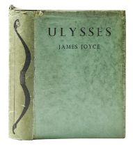
Joyce (James), Ulysses, first trade edition, London: John Lane, The Bodley Head, 1937, half-title,
Joyce (James), Ulysses, first trade edition, London: John Lane, The Bodley Head, 1937, half-title, original publisher's dustjacket, worn, toned, c...
![Local Interest. [Cox (Thomas)], Nottinghamshire, [from Magna Britannia et Hibernia], [In the](https://portal-images.azureedge.net/auctions-2024/srmel10225/images/27bfb376-ab85-4e36-9d1d-b10001075ec2.jpg?h=210)
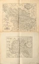
Local Interest. [Cox (Thomas)], Nottinghamshire, [from Magna Britannia et Hibernia], [In the
Local Interest. [Cox (Thomas)], Nottinghamshire, [from Magna Britannia et Hibernia], [In the Savoy: Eliz. Nutt, 1720], double-column, engraved fol...
Local Interest. Thoroton (Robert) & Throsby (John), Thoroton's History of Nottinghamshire: Republished, with Large Additions. And Embellished with...
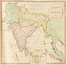
Stackhouse (Thomas), An Universal Atlas Consisting of a Complete Set of Maps, to Illustrate Ancient and Modern Geography [...], [?sixth edition], ...
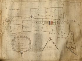
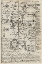
Leicestershire. A Survey of Sundry Lands within the Lordship of Eaton in the County of Leicester,
Leicestershire. A Survey of Sundry Lands within the Lordship of Eaton in the County of Leicester, the Property of Charles Morley of Nottingham, Ge...
![[Atlas] Moll (Herman, Geographer), A Set of Fifty New and Correct Maps of England and Wales, &c.](https://portal-images.azureedge.net/auctions-2024/srmel10225/images/13d705ce-1719-4b72-bf98-b1000108903b.jpg?h=210)
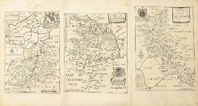
[Atlas] Moll (Herman, Geographer), A Set of Fifty New and Correct Maps of England and Wales, &c.
[Atlas] Moll (Herman, Geographer), A Set of Fifty New and Correct Maps of England and Wales, &c. With The Great Roads and Principal Cross-Roads, &...
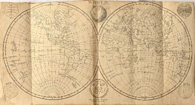
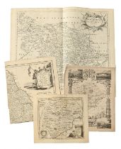
An early 19th c album of 29 maps, plans/charts and diagrams, dated 1805, engraved for Walker's
An early 19th c album of 29 maps, plans/charts and diagrams, dated 1805, engraved for Walker's Geography by W. Darton Jun:r, including a world map...
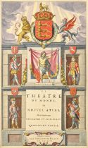
Biblioclasm. Jodocus Hondius (1563-1612) - The Theatre of the Empire of Great Britaine (sic);
Biblioclasm. Jodocus Hondius (1563-1612) - The Theatre of the Empire of Great Britaine (sic); allegorical title-page of John Speed's atlas, London...
![Bowles's New Four-Sheet Map of England and Wales [...], London: Printed for the Proprietors Bowles &](https://portal-images.azureedge.net/auctions-2024/srmel10225/images/26dc3199-1c6c-4333-8fde-b100010893c8.jpg?h=210)
Bowles's New Four-Sheet Map of England and Wales [...], London: Printed for the Proprietors Bowles &
Bowles's New Four-Sheet Map of England and Wales [...], London: Printed for the Proprietors Bowles & Carver, n.d. [1810], engraving over 48 paper ...
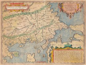
Greece, Thrace. Abraham Ortelius (1527-1598) - Thraciæ Veteris Typus, double-page map, letterpress
Greece, Thrace. Abraham Ortelius (1527-1598) - Thraciæ Veteris Typus, double-page map, letterpress to verso with Latin text, s.l. [Antwerp], 1585,...
![Greenwood (Christopher & John), Atlas of the Counties of England [and Wales], from Actual Surveys](https://portal-images.azureedge.net/auctions-2024/srmel10225/images/f4d5825a-aea2-413c-bfc2-b1000108971d.jpg?h=210)
Greenwood (Christopher & John), Atlas of the Counties of England [and Wales], from Actual Surveys
Greenwood (Christopher & John), Atlas of the Counties of England [and Wales], from Actual Surveys made from the Years 1817 to 1833, Published by t...
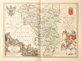
Jan Janssonius/Jan Jansson (1588-1664) - Derbyshire, Shropshire & Staffordshire, Middlesex, Wiltshire and Oxfordshire; five double-page county ma...
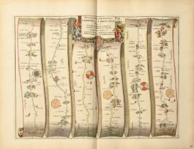
John Ogilby (1600-1676) - Thirty-seven harlequin English road maps, allegorical titles, mixed dates,
John Ogilby (1600-1676) - Thirty-seven harlequin English road maps, allegorical titles, mixed dates, mostly c. 1675, engravings, contemporary or c...
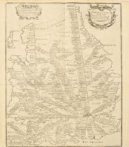
John Overton (1640-1713) - A new mpp (sic) of ye Rodes of England, Showing the Townes (sic) you pass
John Overton (1640-1713) - A new mpp (sic) of ye Rodes of England, Showing the Townes (sic) you pass through with the reputed distance between Tow...
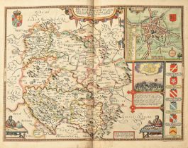
John Speed (1551/52-1629) - Herefordshire, Dorset, Huntingdonshire and Northamptonshire; four
John Speed (1551/52-1629) - Herefordshire, Dorset, Huntingdonshire and Northamptonshire; four double-page county maps, letterpress to verso, mixed...
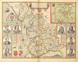
John Speed (1551/52-1629) - Leicestershire, Lancashire, Staffordshire, and The North and East
John Speed (1551/52-1629) - Leicestershire, Lancashire, Staffordshire, and The North and East Ridings of Yorkshire; four double-page county maps, ...
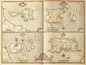
John Speed (1551/52-1629) - The Isle of Man, double-page map, letterpress to verso, s.l., dated 1610
John Speed (1551/52-1629) - The Isle of Man, double-page map, letterpress to verso, s.l., dated 1610 within the plate, engraving, contemporaneous ...
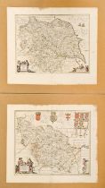
Local Interest. Christopher Greenwood (1786-1855) and John Greenwood (fl.1821-1840) - Map of the
Local Interest. Christopher Greenwood (1786-1855) and John Greenwood (fl.1821-1840) - Map of the County of Nottingham, From an Actual Survey made ...
Miscellaneous GB. Robert Morden (c.1650-1703) - The North, East and West Ridings of Yorkshire; three
Miscellaneous GB. Robert Morden (c.1650-1703) - The North, East and West Ridings of Yorkshire; three maps, s.l., s.n., n.d. [1695], double-page en...
North of England. Joan Blaeu (1596-1673) - Durham, Northumberland, East Riding of Yorkshire,
North of England. Joan Blaeu (1596-1673) - Durham, Northumberland, East Riding of Yorkshire, Lancashire, Cumbria and Westmorland; six double-page ...
Richard Blome (1635–1705) - Nineteen harlequin maps of English and Welsh counties, s.l., s.n., mixed
Richard Blome (1635–1705) - Nineteen harlequin maps of English and Welsh counties, s.l., s.n., mixed dates and states, principally 34.5 x 22cm, (1...
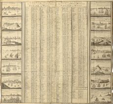
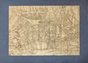
Sutton Nicholls (fl. 1700-1740) - An Alphabetical Table of all the Cities and Market Towns in
Sutton Nicholls (fl. 1700-1740) - An Alphabetical Table of all the Cities and Market Towns in England and Wales, s.l. [London], s.n., n.d. [1724],...
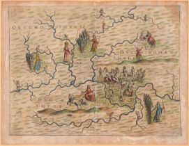
William Hole (d. 1624) - An allegorical map of Oxfordshire, Buckinghamshire and Berkshire, from
William Hole (d. 1624) - An allegorical map of Oxfordshire, Buckinghamshire and Berkshire, from Michael Drayton's Poly-Obion, London, 1612, engrav...
William Kip (act. 1588-1635) after John Norden (1546-1625) - Hertfordshire, double-page county
William Kip (act. 1588-1635) after John Norden (1546-1625) - Hertfordshire, double-page county map, numbered 16 within the plate, s.l., n.d. [firs...
Yorkshire. Jan Janssonius/Jan Jansson (1588-1664) - four double-page county maps, mixed dates, but
Yorkshire. Jan Janssonius/Jan Jansson (1588-1664) - four double-page county maps, mixed dates, but all 17th c, engravings, contemporary or slightl...