Filtered by:
- Category
- List
- Grid
A subscription to the Price Guide is required to view results for auctions ten days or older. Click here for more information
![Topography. [Photographically-illustrated], Harker (B.J.), Rambles in Upper Wharfedale, first](https://portal-images.azureedge.net/auctions-2023/srmel10219/images/e5c46dab-92b9-4e67-ad01-b05100f730cd.jpg?w=155&h=155)

Topography. [Photographically-illustrated], Harker (B.J.), Rambles in Upper Wharfedale, first
Topography. [Photographically-illustrated], Harker (B.J.), Rambles in Upper Wharfedale, first edition, Skipton: Edmondson and Co, 1869, half-title...

British India & the Raj, Amritsar Massacre. Colvin (Ian), The Life of General Dyer, first edition,
British India & the Raj, Amritsar Massacre. Colvin (Ian), The Life of General Dyer, first edition, Edinburgh and London: William Blackwood & Sons ...
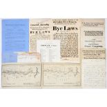
Local Interest. Nine pieces of printed &/or manuscript ephemera relating to Nottinghamshire and
Local Interest. Nine pieces of printed &/or manuscript ephemera relating to Nottinghamshire and Derbyshire canals, late 18th c and later, includin...
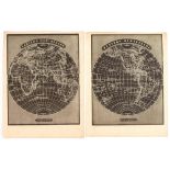
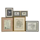
Cartography. A miscellaneous collection of small format maps, early 19th c and later, comprising
Cartography. A miscellaneous collection of small format maps, early 19th c and later, comprising approx. 30 world maps, some hand-coloured, includ...
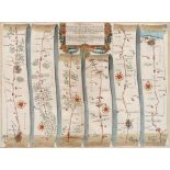
John Ogilby (1600-1676) - The Road from Ipswich, Suffolk, to Norwich and thence to Cromer on the Sea
John Ogilby (1600-1676) - The Road from Ipswich, Suffolk, to Norwich and thence to Cromer on the Sea Coast, Norfolk, double-page map, s.l., s.n., ...
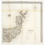
![Robert Morden (c. 1650-1703) - Herefordshire, double-page county map, [London]: Sold by Abel Swale,](https://portal-images.azureedge.net/auctions-2023/srmel10219/images/3c725197-c202-4f94-8601-b05100f991a6.jpg?w=155&h=155)
Robert Morden (c. 1650-1703) - Herefordshire, double-page county map, [London]: Sold by Abel Swale,
Robert Morden (c. 1650-1703) - Herefordshire, double-page county map, [London]: Sold by Abel Swale, Awnsham & John Churchill, dated 1695 in MS by...
Scotland. John Crane Dower & T. Harwood after F.A. & G.W. Carrington - A Map of Scotland, Divided
Scotland. John Crane Dower & T. Harwood after F.A. & G.W. Carrington - A Map of Scotland, Divided into Counties shewing (sic) The principal Roads,...
![Wales. John Speed (1551/52-1629) - Caernarvon [i.e. Caernarfon]/both shyre (sic) and/shire-towne (](https://portal-images.azureedge.net/auctions-2023/srmel10219/images/4d9332cf-387e-498f-91e5-b05100f9ac1d.jpg?w=155&h=155)
Wales. John Speed (1551/52-1629) - Caernarvon [i.e. Caernarfon]/both shyre (sic) and/shire-towne (
Wales. John Speed (1551/52-1629) - Caernarvon [i.e. Caernarfon]/both shyre (sic) and/shire-towne (sic), double-page county map, English text to ve...
Napoleonic Wars. Bacler d'Albe (1761-1824), Carte générale du théâtre de la guerre en Italie et dans
Napoleonic Wars. Bacler d'Albe (1761-1824), Carte générale du théâtre de la guerre en Italie et dans les Alpes; Carte générale des royaumes de Nap...
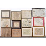
Maps, 18th and 19th c British county maps, mixed publishers and dates, mostly engravings and
Maps, 18th and 19th c British county maps, mixed publishers and dates, mostly engravings and mostly framed, etc., (20) Mixed condition ...[more]
Maps, 19th c and later, various Mixed condition. ...[more]