Filtered by:
- Category,
- Creator / Brand
- List
- Grid
A subscription to the Price Guide is required to view results for auctions ten days or older. Click here for more information
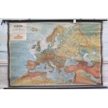

An Austrian map of Europe, published by Freytag-Berndt and Artaria, Vienna, depicting railway
An Austrian map of Europe, published by Freytag-Berndt and Artaria, Vienna, depicting railway lines 106cm x 152cm ...[more]
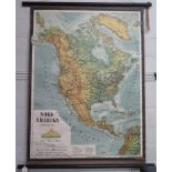
An Austrian map of North America, published by Freytag-Brendt and Artiria, Vienna 106cm x 78cm
An Austrian map of North America, published by Freytag-Brendt and Artiria, Vienna 106cm x 78cm ...[more]
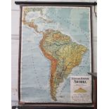
An Austrian map of South and Central America, published by Freytag-Brendt and Artaria, Vienna
An Austrian map of South and Central America, published by Freytag-Brendt and Artaria, Vienna 107cm x 78cm ...[more]
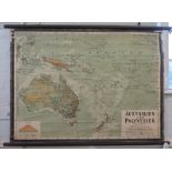
An Austrian map of Australia and Polynesia, published by Freytag-Brendt and Artaria, Vienna, 77cm
An Austrian map of Australia and Polynesia, published by Freytag-Brendt and Artaria, Vienna, 77cm x 107cm

A pictorial map of South America, published by Georg Westerman, no. 566 showing wild animals and
A pictorial map of South America, published by Georg Westerman, no. 566 showing wild animals and plants 118cm x 90cm
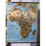
A pictorial map of Africa, published by Georg Westerman no. 553 showing wild animals and plants
A pictorial map of Africa, published by Georg Westerman no. 553 showing wild animals and plants 118cm x 90cm
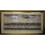
*After Johannes Kip (c1653 - 1722) A Prospect at Westminster With key to major buildings Copper
*After Johannes Kip (c1653 - 1722) A Prospect at Westminster With key to major buildings Copper engraving on two sheets 49cm x 114cm ...[more]
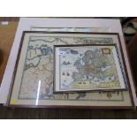
A French 19th century map of the States of Prussia 25cm x 35cm and six other reproduction maps
A French 19th century map of the States of Prussia 25cm x 35cm and six other reproduction maps