
Filtered by:
- Category,
- Item Type
- List
- Grid
A subscription to the Price Guide is required to view results for auctions ten days or older. Click here for more information


Thomas William Hammond (British, 1854-1935), 'The Casquets', pastel, laid onto board, signed lower
Thomas William Hammond (British, 1854-1935), 'The Casquets', pastel, laid onto board, signed lower right, modern hollow gilt frame15¼ x 29¼in. (38...
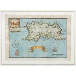
Hand coloured Map of Jersey, by Blome, engraving on laid paper, laid onto laid paper, circa 1670,
Hand coloured Map of Jersey, by Blome, engraving on laid paper, laid onto laid paper, circa 1670, framed, 5½ x 8in. (14 x 20.3cm.). * Condition: V...
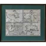
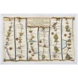
John Speed (1552-1629), Maps of four Islands - "Holy Iland", "Garnsey" (Guernsey), "Farne" and "
John Speed (1552-1629), Maps of four Islands - "Holy Iland", "Garnsey" (Guernsey), "Farne" and "Jarsey" (Jersey)", pub. by Thomas Bassett and Rich...
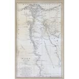
Antique map of Egypt, Egypt called in the Country Missir" by J.B. Danville, engraved by J. Cooke, c.
Antique map of Egypt, Egypt called in the Country Missir" by J.B. Danville, engraved by J. Cooke, c. 1799, 26 x 16in. (66 x 40.7cm.), frame, glaze...
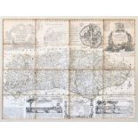
Eman Bowen - An accurate map of the county of Sussex, divided into its rapes, deanries and hundreds,
Eman Bowen - An accurate map of the county of Sussex, divided into its rapes, deanries and hundreds, 18th century, 20 x 26½in. (50.8 x 67.4cm.), f...
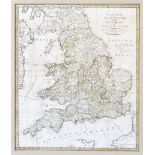
Wallis's New and Correct Map of the Post Roads of England & Wales, with outline colouring, Pub. by
Wallis's New and Correct Map of the Post Roads of England & Wales, with outline colouring, Pub. by John Wallis, at his Map Warehouse, No.16 Ludgat...
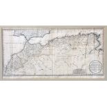
A map of North Africa including the Kingdoms of Morocco, Fez, Algiers and Tunis, according to
A map of North Africa including the Kingdoms of Morocco, Fez, Algiers and Tunis, according to Spanish cartographer Thomás López, 15¼ x 31in. (38.7...
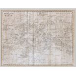
World Map - A Mercator Chart of the World by Thomas Bowen, c.1778, Sandwich Islands not yet added,
World Map - A Mercator Chart of the World by Thomas Bowen, c.1778, Sandwich Islands not yet added, British Colonies in America, Alaska (Alaschka)a...
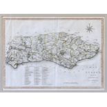
J. Cary - A Map of Sussex, from the beft Authorities, Pub. John Stockdale, Piccadilly, 26th March
J. Cary - A Map of Sussex, from the beft Authorities, Pub. John Stockdale, Piccadilly, 26th March 1805, hand coloured, 14½ x 20in. (36.8 x 50.8cm....
Thomas Gardener - two maps: Sir Arthur Owen, map plan 'The road from London to St. Davids', and
Thomas Gardener - two maps: Sir Arthur Owen, map plan 'The road from London to St. Davids', and Sir Edward Williams, 'The road from Monmouth to Ll...
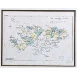
Edward Stanford - 1936 map of The Falkland Islands, based on Admiralty charts No's 1354A and
Edward Stanford - 1936 map of The Falkland Islands, based on Admiralty charts No's 1354A and 1354B, pencil inscription lower right, 11¾ x 15¾in. (...