Filtered by:
- Category,
- Item Type
- List
- Grid
A subscription to the Price Guide is required to view results for auctions ten days or older. Click here for more information
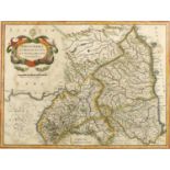

Hendrick II Hondius (c.1597-c.1651) Northumbria Cumberlandia et Dunelmensis Episcopatus, hand
Hendrick II Hondius (c.1597-c.1651) Northumbria Cumberlandia et Dunelmensis Episcopatus, hand coloured map, 34cm x 46cm together with John Ogilby ...
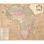
Jean Palairet (1697-1774) Map of African according to D'Anville, hand coloured print, 48cm x 57cmAt present, there is no condition report prepared...
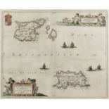
Johannes Blaeu (1650-1712) Hand coloured map depicting Guernsey and Jersey, 39cm x 48cm In good
Johannes Blaeu (1650-1712) Hand coloured map depicting Guernsey and Jersey, 39cm x 48cm In good condition, with some minor discolouration ...[mor...

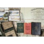
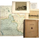
Windsor Castle interest:- Hakewill, James. The History of Windsor. Lloyd, London 1813. Fo. Marbled
Windsor Castle interest:- Hakewill, James. The History of Windsor. Lloyd, London 1813. Fo. Marbled boards plus Goddard, Arthur. 'Windsor The Castl...

Dekker, (Elly). Globes at Greenwich. O.U.P. 1999 d/w plus a collection of related titles and art
Dekker, (Elly). Globes at Greenwich. O.U.P. 1999 d/w plus a collection of related titles and art reference (10) ...[more]
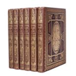
Morris, (The Rev. F.D. Ed). 'A Series of Picturesque Views of Seats of The Noblemen and Gentlemen of
Morris, (The Rev. F.D. Ed). 'A Series of Picturesque Views of Seats of The Noblemen and Gentlemen of Great Britain and Ireland'. 6 vols. 4to. Mack...
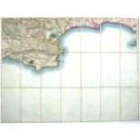
Cartography:- J & C Walker, Holborn England and Wales, The Grand Trigonometrical Survey c1840. (
Cartography:- J & C Walker, Holborn England and Wales, The Grand Trigonometrical Survey c1840. (approximately 130 x 110cm) in outer leather slip c...

Ordnance Maps of England sold by Letts, Son & Steer. 8 Royal Exchange (London). A set of 16 folding maps in 4 slip cases c1850 in used condition (...
Ministry of Transport folding Road Maps c1930. 35 out of a set of 40. approximately 65cm square plus
Ministry of Transport folding Road Maps c1930. 35 out of a set of 40. approximately 65cm square plus six further maps, all in carrying case ...[m...
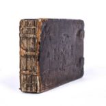
Speed, (John) (1552-1629). A Miniature Atlas: England, Wales,Scotland and Ireland Described,
Speed, (John) (1552-1629). A Miniature Atlas: England, Wales,Scotland and Ireland Described, George Humble, Pope's Head Alley, London 1627. Oblong...
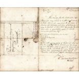
Office of Ordnance 12th January 1727 A 'Hulking' Order for H.M.S. Southampton , with instructions,
Office of Ordnance 12th January 1727A 'Hulking' Order for H.M.S. Southampton , with instructions, m/s in black ink, signed Edward Short, framed (3...
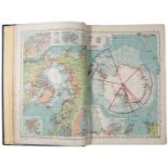
Serial Map Service Atlas, George Philip and Son, London 1945. Fo. plus two Ordnance Survey Atlases
Serial Map Service Atlas, George Philip and Son, London 1945. Fo. plus two Ordnance Survey Atlases plus Journals etc including Birth Control News ...
Stanford, (Edward). London Ordnance Survey Map 25(?) miles round Oxford in slip case plus Oxfordshire/Dobuni tribe extract from 'Camden's Britanni...
Four 19th century Ordnance Survey maps vis. Corfe Castle, Cornwall, Portland Bill, Devon, two
Four 19th century Ordnance Survey maps vis. Corfe Castle, Cornwall, Portland Bill, Devon, two retailed by Edward Stanford, in slip cases (4) ...[...
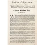
An 18th century printed copy of the Agreement of 1695 between Lord Bellamont and Capt. William
An 18th century printed copy of the Agreement of 1695 between Lord Bellamont and Capt. William Kidd printed in 1701, the years of the former's dea...