Filtered by:
- Category
- List
- Grid
A subscription to the Price Guide is required to view results for auctions ten days or older. Click here for more information

ATLAS - GALL & INGLIS, PUBLISHERSTHE EDINBURGH IMPERIAL ATLAS, ANCIENT AND MODERN Revised and
ATLAS - GALL & INGLIS, PUBLISHERSTHE EDINBURGH IMPERIAL ATLAS, ANCIENT AND MODERN Revised and corrected to the Present Time. Edinburgh: Gall & Ing...
COLLINS, GREENVILLETHE EAST COAST OF SCOTLAND WITH THE ISLES OF ORKNEY AND SHETLAND [London: 1693,
COLLINS, GREENVILLETHE EAST COAST OF SCOTLAND WITH THE ISLES OF ORKNEY AND SHETLAND [London: 1693, or later], 490 x 585mm, hand-coloured, not laid...
![DORRET, JAMESA GENERAL MAP OF SCOTLAND AND ISLANDS THERETO BELONGING [1750], linen-backed map](https://portal-images.azureedge.net/auctions-2019/srly10234/images/dc28cad5-768e-4668-82f6-aa570099c75d.jpg?w=155&h=155)
DORRET, JAMESA GENERAL MAP OF SCOTLAND AND ISLANDS THERETO BELONGING [1750], linen-backed map
DORRET, JAMESA GENERAL MAP OF SCOTLAND AND ISLANDS THERETO BELONGING [1750], linen-backed map mounted on rollers, 1337 x 1770mm, some browning, a ...
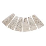
CORONELLI, VINCENZO MARIAFINE SET OF 24 UNJOINED GLOBE GORES FOR 42 INCH (3 1/2 - FOOT) TERRESTRIAL GLOBE comprising 12 gores of the northern hemi...
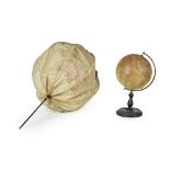
GLOBES - GEORGE PHILIP & SONPHILIP'S BRITISH EMPIRE GLOBE London: George Philip & Son Ltd., 32 Fleet
GLOBES - GEORGE PHILIP & SONPHILIP'S BRITISH EMPIRE GLOBE London: George Philip & Son Ltd., 32 Fleet Street, Printed in Great Britain, 8" globe on...
MOUNT, J. & T. PAGEA NEW CHART OF THE SEA COAST OF SCOTLAND London : W. & J. Mount & T. Page, [c.
MOUNT, J. & T. PAGEA NEW CHART OF THE SEA COAST OF SCOTLAND London : W. & J. Mount & T. Page, [c. 1749] 481 x 551mm, with notes in an early hand t...
ORDNANCE SURVEY OF EDINBURGHSHIREFINELY BOUND SIX INCH FIRST EDITION MAP OF THE EDINBURGH AREA
ORDNANCE SURVEY OF EDINBURGHSHIREFINELY BOUND SIX INCH FIRST EDITION MAP OF THE EDINBURGH AREA Southampton: Ordnance Map Office & Lt. Col. H. Jame...
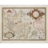
![ORTELIUS, ABRAHAM - ASIAINDIAE ORIENTALIS, INSULARUMQUE ADIACIENTIUM TYPUS Antwerp, [1570 or later],](https://portal-images.azureedge.net/auctions-2019/srly10234/images/d19700a7-638a-4188-9773-aa57009a8e79.jpg?w=155&h=155)
ORTELIUS, ABRAHAM - ASIAINDIAE ORIENTALIS, INSULARUMQUE ADIACIENTIUM TYPUS Antwerp, [1570 or later],
ORTELIUS, ABRAHAM - ASIAINDIAE ORIENTALIS, INSULARUMQUE ADIACIENTIUM TYPUS Antwerp, [1570 or later], engraved map hand-coloured in outline, 355 x ...
ORTELIUS, ABRAHAMTARTARIAE SIVE MAGNI CHAMI REGNI TYPUS 1573, 435 x 542mm, hand-coloured, Latin text
ORTELIUS, ABRAHAMTARTARIAE SIVE MAGNI CHAMI REGNI TYPUS 1573, 435 x 542mm, hand-coloured, Latin text to reverse ...[more]
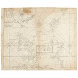
![SAYER, ROBERTTHE ASIATIC & EUROPEAN PART[S] OF THE RUSSIAN EMPIRE London: Robert Sayer, 1788-1790,](https://portal-images.azureedge.net/auctions-2019/srly10234/images/42059473-b28f-402c-8be2-aa57009aa452.jpg?w=155&h=155)
SAYER, ROBERTTHE ASIATIC & EUROPEAN PART[S] OF THE RUSSIAN EMPIRE London: Robert Sayer, 1788-1790,
SAYER, ROBERTTHE ASIATIC & EUROPEAN PART[S] OF THE RUSSIAN EMPIRE London: Robert Sayer, 1788-1790, two maps framed together, hand-coloured in outl...
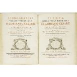
LIGORIO, PIRROICHNOGRAPHIA VILLÆ TIBURTINÆ HADRIANI CÆSARIS olim a Pyrrho Ligorio delineata et
LIGORIO, PIRROICHNOGRAPHIA VILLÆ TIBURTINÆ HADRIANI CÆSARIS olim a Pyrrho Ligorio delineata et descripta, postea a Francisco Continio ... recognit...
WHISTON, WILLIAM AND HUMPHREY DITTONA NEW METHOD FOR DISCOVERING LONGITUDE BOTH AT SEA AND LAND
WHISTON, WILLIAM AND HUMPHREY DITTONA NEW METHOD FOR DISCOVERING LONGITUDE BOTH AT SEA AND LAND London: Mr Whiston and Mrs Ditton, 1715. Second ed...
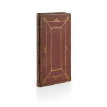
![[PRÉVOST D'EXILES, L'ABBÉ ANTOINE FRANÇOIS]HISTOIRE GENERALE DES VOYAGES Paris: Chez Didot, 1748,](https://portal-images.azureedge.net/auctions-2019/srly10234/images/d8c505a7-96a5-431d-8679-aa57009a8904.jpg?w=155&h=155)
[PRÉVOST D'EXILES, L'ABBÉ ANTOINE FRANÇOIS]HISTOIRE GENERALE DES VOYAGES Paris: Chez Didot, 1748,
[PRÉVOST D'EXILES, L'ABBÉ ANTOINE FRANÇOIS]HISTOIRE GENERALE DES VOYAGES Paris: Chez Didot, 1748, 1750, 1757. Volumes 16, 29 and 51 only, 12mo, vo...