
Filtered by:
- Category,
- Creator / Brand
- List
- Grid
This auctioneer has chosen to not publish their results. Please contact them directly for any enquiries.
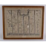

Ogilby (John). Hand-coloured engraved strip map, 'The Road from Bristol to Exeter', circa 18th
Ogilby (John). Hand-coloured engraved strip map, 'The Road from Bristol to Exeter', circa 18th Century, framed & glazed, image size 49.5cm x 40cm ...
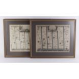
Ogilby (John). Hand-coloured engraved strip map, 'The Road From King's Lynn co Norf. To Harwich
Ogilby (John). Hand-coloured engraved strip map, 'The Road From King's Lynn co Norf. To Harwich Essex, circa 18th Century, mounted, framed & glaze...
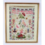
Sampler. by Mary Ann Hanchett (aged 11 yrs) 1860. Framed. Size 28cm x 38cm.
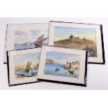
Water colours, mounted, various views by Maltese artist. (4)
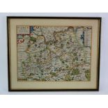
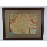
Blaeu (Johannes). Hand-coloured engraved map, circa 17th Century, 'Wigorniensis Comitatus et
Blaeu (Johannes). Hand-coloured engraved map, circa 17th Century, 'Wigorniensis Comitatus et Comitatus Warwicensis, nec non Coventrae Libertas', 5...
Engraved maps. A collection of ten engraved maps (mostly hand-coloured), circa 19th Century,
Engraved maps. A collection of ten engraved maps (mostly hand-coloured), circa 19th Century, including Tallis etc., depicting Ireland, Staffordshi...
Kip (William). Hand-coloured engraved map, circa 17th Century ' Surrey olim sedes Regnorum',
Kip (William). Hand-coloured engraved map, circa 17th Century ' Surrey olim sedes Regnorum', mounted, framed & glazed, image size 38cm x 29cm appr...
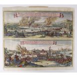
Merian (Matthaus). Hand-coloured double prospect of the Dutch raid on River Medway, circa 17th
Merian (Matthaus). Hand-coloured double prospect of the Dutch raid on River Medway, circa 17th Century 'Abbildung der Statt und Revier von Rochest...
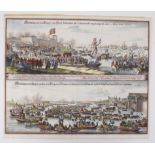
Merian (Matthaus). Hand-coloured double prospect of the landing of Catherine of Braganza at Portsmouth, prior to her marriage to Charles II, circa...
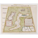
Munster (Sebastian). Hand-coloured engraved map, circa 16th Century, 'Tabula Europae I', 36.5cm x
Munster (Sebastian). Hand-coloured engraved map, circa 16th Century, 'Tabula Europae I', 36.5cm x 29.5cm approx.
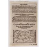
Munster (Sebastian). Small uncoloured woodcut map, circa 16th Century, 'Von den Britannischen inseln
Munster (Sebastian). Small uncoloured woodcut map, circa 16th Century, 'Von den Britannischen inseln Albione das ist Engelland und Hibernia...', m...
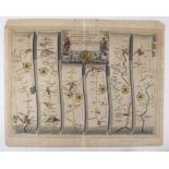
Ogilby (John). Hand-coloured engraved strip map, circa 18th Century, 'The Road from Glocester to
Ogilby (John). Hand-coloured engraved strip map, circa 18th Century, 'The Road from Glocester to Coventrey', 47.5cm x 38cm approx.
Speed (John). Hand-coloured engraved map, circa 17th Century, 'Hartfordshire Described, The sittuations of Hartford and the most ancient towne S. ...
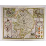
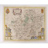
Speed (John). Hand-coloured engraved map, dated 1610, 'The Counti of Warwick, The Shire Towne of
Speed (John). Hand-coloured engraved map, dated 1610, 'The Counti of Warwick, The Shire Towne of Coventre Described', 5cm split to centre fold at ...
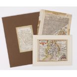
Warwickshire interest. Three small engraved maps of Warwickshire (two hand-coloured), circa 17th /
Warwickshire interest. Three small engraved maps of Warwickshire (two hand-coloured), circa 17th / 18th Century, including one by Robert Morden, l...