
Filtered by:
- Category,
- Item Type
- List
- Grid
A subscription to the Price Guide is required to view results for auctions ten days or older. Click here for more information
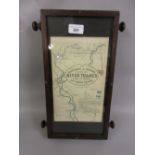

The Oarsman's and Anglers map of the river Thames from its source to London Bridge, 1in to a mile,
The Oarsman's and Anglers map of the river Thames from its source to London Bridge, 1in to a mile, mounted in an oak case on rollers

Twenty two Atlas edition models of World War II aircraft
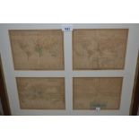
Four small hand coloured maps of the World including: The Waters of the Globe, Meteorology, The
Four small hand coloured maps of the World including: The Waters of the Globe, Meteorology, The Animal Kingdom, housed in a single oak frame toget...
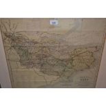
19th Century hand coloured Cruchley's County map of Kent from Ordnance surveys, gilt framed, 19ins x
19th Century hand coloured Cruchley's County map of Kent from Ordnance surveys, gilt framed, 19ins x 21.5ins
Quantity of various unframed maps, engravings etc.
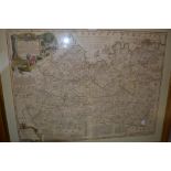
Emanuel Bowen, antique gilt framed map of Surrey, 21ins x 28ins (heavily restored), antique maple
Emanuel Bowen, antique gilt framed map of Surrey, 21ins x 28ins (heavily restored), antique maple framed hand coloured map of France, 12ins x 16in...
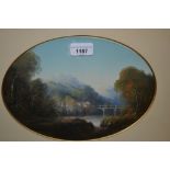
G. Lambert, oval mounted oil, ' View at Crow Castle, Wales ', signed, gilt framed