Filtered by:
- Category
- List
- Grid
A subscription to the Price Guide is required to view results for auctions ten days or older. Click here for more information

Blaeu, Jan. Suthsexia Vernacule Sussex, hand-coloured engraved map, Dutch text verso, some surface
Blaeu, Jan. Suthsexia Vernacule Sussex, hand-coloured engraved map, Dutch text verso, some surface soiling, light stain along fold, 518mm x 376mm,...
Blaeu, Jan. Ducatus Eboracensis Pars Borealis. The North-Riding of Yorkshire, hand-coloured engraved
Blaeu, Jan. Ducatus Eboracensis Pars Borealis. The North-Riding of Yorkshire, hand-coloured engraved map, Latin text verso, some staining to lower...
Blaeu, Jan. Comitatus Salopiensis Anglice Shrop shire, hand-coloured engraved map, edges slightly
Blaeu, Jan. Comitatus Salopiensis Anglice Shrop shire, hand-coloured engraved map, edges slightly browned, 482mm x 364mm, [Amsterdam, c.1645 or la...
Blaeu, Johannes. Comitatus Northumbria vernacule Northumberland, hand-coloured engraved map,
Blaeu, Johannes. Comitatus Northumbria vernacule Northumberland, hand-coloured engraved map, browned, split along fold, 491mm x 408mm, Amsterdam, ...
Blaeu, Willem. Bercheria Vernacule Barkshire, hand-coloured engraved map, margins cropped, 492mm x
Blaeu, Willem. Bercheria Vernacule Barkshire, hand-coloured engraved map, margins cropped, 492mm x 385mm, [Amsterdam, 1645 or later], framed; Vau...
D'Anville, J.B. Persian Gulph, hand-coloured engraved map, tears to margins, slightly affecting
D'Anville, J.B. Persian Gulph, hand-coloured engraved map, tears to margins, slightly affecting border, 430mm x 292mm, London: John Harrison, 1788...
Greenville Collins, Captain. [East Coast of England from Dover to Firth of Forth], hand-coloured
Greenville Collins, Captain. [East Coast of England from Dover to Firth of Forth], hand-coloured engraved map, cartouche dedicated to Sir Ralph De...
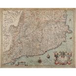
Hondius, Jodocus. Cataloniae Principatus Descriptio Nova, hand-coloured engraved map, some loss to
Hondius, Jodocus. Cataloniae Principatus Descriptio Nova, hand-coloured engraved map, some loss to upper margin, slightly affectiing border, 482mm...
Greenwood, Charles and John. Map of the County of Devon, hand-coloured engraved map, 695mm x
Greenwood, Charles and John. Map of the County of Devon, hand-coloured engraved map, 695mm x 615mm, London: Greenwood & Co., July 4th, 1829, frame...
Kishida Ginko. Jutei gosai chugai hoyo zenzu, large folding lithographed map of China and Japan,
Kishida Ginko. Jutei gosai chugai hoyo zenzu, large folding lithographed map of China and Japan, backed on linen, eight inset plans, text in Japan...
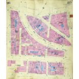
London, Insurance Plans - Docklands. A volume of 58 highly detailed street plans by Charles E.
London, Insurance Plans - Docklands. A volume of 58 highly detailed street plans by Charles E. Goad Ltd, Civil Engineers, 40ft to the inch, the bu...
London, Insurance Plans - Embankment, Long Acre and Holborn. A volume of 53 highly detailed street
London, Insurance Plans - Embankment, Long Acre and Holborn. A volume of 53 highly detailed street plans by Charles E. Goad Ltd, Civil Engineers, ...
London, Insurance Plans - London Bridge and Surrey Commercial Docks. A volume of 54 highly detailed street plans by Charles E. Goad Ltd, Civil Eng...
London, Insurance Plans - Soho, St. James', Regent Street and Oxford Street. A volume of 58 highly
London, Insurance Plans - Soho, St. James', Regent Street and Oxford Street. A volume of 58 highly detailed street plans by Charles E. Goad Ltd, C...
Martin, Robert Montgomery. [Tallis's Illustrated Atlas], 81 double-page engraved maps and plans,
Martin, Robert Montgomery. [Tallis's Illustrated Atlas], 81 double-page engraved maps and plans, 80 hand-coloured in outline, a few loose, some br...
Mercator, Gerard. Cornubia, Devonia, Somersetus, Dorcestria, Wiltonia, Glocestria..., hand-
Mercator, Gerard. Cornubia, Devonia, Somersetus, Dorcestria, Wiltonia, Glocestria..., hand-coloured engraved map, 470mm x 370mm, [c.1630], framed ...
Moscow. A large lithographed city plan, the zones highlighted with colour, with a cartouche lower
Moscow. A large lithographed city plan, the zones highlighted with colour, with a cartouche lower right of the Kremlin, 693mm x 595mm, Moscow, 188...
Ogilby, John. The Continuation of the Road from London to Land's End [Plymouth to Land's End],
Ogilby, John. The Continuation of the Road from London to Land's End [Plymouth to Land's End], hand-coloured engraved strip-map, some browning, 47...
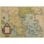
Ortelius, Abraham. Graeciae universae secundum hodiernum, situm, neoterica descriptio, hand-coloured
Ortelius, Abraham. Graeciae universae secundum hodiernum, situm, neoterica descriptio, hand-coloured engraved map, cleaned and laid-down, 510mm x ...
Quin, Edward. An Historical Atlas; in a Series of Maps of the World as Known at Different Periods,
Quin, Edward. An Historical Atlas; in a Series of Maps of the World as Known at Different Periods, 20 [of 21] hand-coloured engraved plates after ...
Saxton, Christopher, and William Hole. Eboracensis Comitatus pars Septentrionalis vulgo North
Saxton, Christopher, and William Hole. Eboracensis Comitatus pars Septentrionalis vulgo North Riding, hand-coloured engraved map, 352mm x 198mm, [...
Smith, Charles. Smith's New general Atlas containing Disinct Maps of All the Principal Empires,
Smith, Charles. Smith's New general Atlas containing Disinct Maps of All the Principal Empires, Kingdoms and States throughout the World, engraved...
Sanson D'Abbeville, Nicholas. Le Royaume d'Escosse, engraved map on two sheets, joined, hand-
Sanson D'Abbeville, Nicholas. Le Royaume d'Escosse, engraved map on two sheets, joined, hand-coloured in outline, some discolouration and spotting...
Speed, John. The County Palatine of Chester, with that most ancient citie described, hand-coloured
Speed, John. The County Palatine of Chester, with that most ancient citie described, hand-coloured engraved map, English text verso, very minor re...
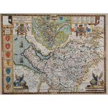
Speed, John. The North and East Ridins of Yorkshire, hand-coloured engraved map, English text verso,
Speed, John. The North and East Ridins of Yorkshire, hand-coloured engraved map, English text verso, minor tears to lower margin, 512mm x 387mm, L...
Speed, John. Somerset-shire Described: ad into Hundreds devided, with the plott of the famous and
Speed, John. Somerset-shire Described: ad into Hundreds devided, with the plott of the famous and most wholson waters and citie of the Bathe, hand...
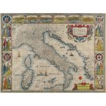
Speed. John. Italia, hand-coloured engraved map, creased along fold, upper right corner detached,
Speed. John. Italia, hand-coloured engraved map, creased along fold, upper right corner detached, affecting margin, but touching plate-mark, 515mm...
Thomson, John. North (and South) Africa, hand-coloured engraved maps, printed on a single sheet,
Thomson, John. North (and South) Africa, hand-coloured engraved maps, printed on a single sheet, slightly browned, 515mm x 580mm, Edinburgh: John ...