Filtered by:
- Category
- List
- Grid
A subscription to the Price Guide is required to view results for auctions ten days or older. Click here for more information

COL SIR HENRY JAMES: EXTENSION OF THE TRIANGULATION OF THE ORDNANCE SURVEY INTO FRANCE AND BELGIUM
COL SIR HENRY JAMES: EXTENSION OF THE TRIANGULATION OF THE ORDNANCE SURVEY INTO FRANCE AND BELGIUM WITH THE MEASUREMENT OF AN ARC OF PARALLEL IN L...
HENRY HUMPHRY EVANS LLOYD: A POLITICAL AND MILITARY RHAPSODY ON THE INVASION AND DEFENCE OF GREAT
HENRY HUMPHRY EVANS LLOYD: A POLITICAL AND MILITARY RHAPSODY ON THE INVASION AND DEFENCE OF GREAT BRITAIN AND IRELAND...TO WHICH IS ADDED A SUPPLE...
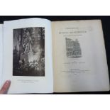
J W ROBBERDS & JAMES STARK: PICTURESQUE VIEWS ON AND NEAR THE EASTERN COAST OF ENGLAND COMPRISING
J W ROBBERDS & JAMES STARK: PICTURESQUE VIEWS ON AND NEAR THE EASTERN COAST OF ENGLAND COMPRISING THE ROMANTIC SCENERY OF THE YARE, THE WAVENEY AN...
RICHARD WRIGHT PROCTER: MEMORIALS OF BYGONE MANCHESTER WITH GLIMPSES OF THE ENVIRONS, Manchester,
RICHARD WRIGHT PROCTER: MEMORIALS OF BYGONE MANCHESTER WITH GLIMPSES OF THE ENVIRONS, Manchester, Palmer & Howe, 1880, plates collated complete, f...
![THOMAS READ: NORFOLK, engraved hand coloured map [1744], approx 150 x 195mm, framed and glazed](https://portal-images.azureedge.net/auctions-2020/srkey10429/images/231ca978-6776-4a56-881d-ac8a00a25358.jpg?w=155&h=155)
THOMAS READ: NORFOLK, engraved hand coloured map [1744], approx 150 x 195mm, framed and glazed
THOMAS READ: NORFOLK, engraved hand coloured map [1744], approx 150 x 195mm, framed and glazed ...[more]
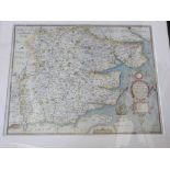
![JOHN SPEED: NORFOLK..., engraved hand coloured map [1627], English text verso, approx 380 x 510mm,](https://portal-images.azureedge.net/auctions-2020/srkey10429/images/38f527ab-eef4-4162-a2db-ac8a00a25687.jpg?w=155&h=155)
JOHN SPEED: NORFOLK..., engraved hand coloured map [1627], English text verso, approx 380 x 510mm,
JOHN SPEED: NORFOLK..., engraved hand coloured map [1627], English text verso, approx 380 x 510mm, double glazed framed ...[more]
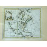
THOMAS JEFFERYS: NORTH AMERICA, engraved hand coloured map circa 1750, approx 180 x 225mm, framed
THOMAS JEFFERYS: NORTH AMERICA, engraved hand coloured map circa 1750, approx 180 x 225mm, framed and glazed ...[more]
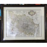
SAXTON/HOLE: EBORACENSIS...WEST RIDING, engraved hand coloured map circa 1630, approx 260 x 320mm,
SAXTON/HOLE: EBORACENSIS...WEST RIDING, engraved hand coloured map circa 1630, approx 260 x 320mm, framed and glazed ...[more]
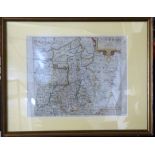
SAXTON/HOLE: COMITATUS BERCHERIAE..., (Berkshire), engraved hand coloured map, circa 1630, approx
SAXTON/HOLE: COMITATUS BERCHERIAE..., (Berkshire), engraved hand coloured map, circa 1630, approx 228 x 320mm, framed and glazed ...[more]
SAXTON/KIPP: CAMBRIDGE, engraved hand coloured map circa 1637, approx 280 x 315mm, framed and
SAXTON/KIPP: CAMBRIDGE, engraved hand coloured map circa 1637, approx 280 x 315mm, framed and glazed ...[more]
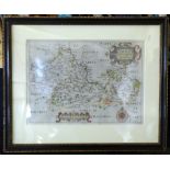
WILLIAM SMITH: ESSEXIAE COMITATUS, engraved hand coloured map, 1602, scarce issue, approx 405 x
WILLIAM SMITH: ESSEXIAE COMITATUS, engraved hand coloured map, 1602, scarce issue, approx 405 x 501mm, framed and glazed ...[more]