Filtered by:
- Category,
- Creator / Brand
- List
- Grid
This auctioneer has chosen to not publish their results. Please contact them directly for any enquiries.
![FRANCIS QUARLES: EMBLEMES, London, [1669?], lacks all before "To the reader", ends page 378,](https://portal-images.azureedge.net/auctions-2020/srkey10319/images/a2d81747-8e5a-4e80-8a7b-ab5900c55957.jpg?w=155&h=155)

FRANCIS QUARLES: EMBLEMES, London, [1669?], lacks all before "To the reader", ends page 378,
FRANCIS QUARLES: EMBLEMES, London, [1669?], lacks all before "To the reader", ends page 378, modern cloth, printed paper label
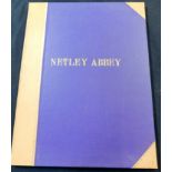
WILLIAM WESTALL: VIEWS OF NETLEY ABBEY, London, Engelmann Graf Combet & Co, 1828, 1st edition, added
WILLIAM WESTALL: VIEWS OF NETLEY ABBEY, London, Engelmann Graf Combet & Co, 1828, 1st edition, added engraved vignette title and 10 plates, title ...
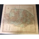
GEORGE ELLER: MEMORIALS ARCHAEOLOGICAL AND ECCLESIASTICAL OF THE WEST WINCH MANORS..., Kings Lynn
GEORGE ELLER: MEMORIALS ARCHAEOLOGICAL AND ECCLESIASTICAL OF THE WEST WINCH MANORS..., Kings Lynn Thew & Son, 1861, 1st edition, printed for priva...
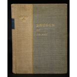
MAGNUS BLOMSTEDT AND FREDRIK BOOK (EDS): SWEDEN OF TO-DAY, A SURVEY OF ITS INTELLECTUAL AND MATERIAL
MAGNUS BLOMSTEDT AND FREDRIK BOOK (EDS): SWEDEN OF TO-DAY, A SURVEY OF ITS INTELLECTUAL AND MATERIAL CULTURE, Stockholm, 1930, 1st edition, 4to, o...
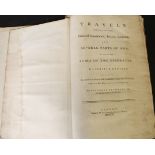
ALEXANDER DRUMMOND: TRAVELS THROUGH DIFFERENT CITIES OF GERMANY, ITALY, GREECE AND SEVERAL PARTS
ALEXANDER DRUMMOND: TRAVELS THROUGH DIFFERENT CITIES OF GERMANY, ITALY, GREECE AND SEVERAL PARTS OF ASIA AS FAR AS THE BANKS OF THE EUPHRATES..., ...
DOMESDAY BOOK OR THE GREAT SURVEY OF ENGLAND OF WILLIAM THE CONQUEROR...FAC-SIMILE OF THE PART
DOMESDAY BOOK OR THE GREAT SURVEY OF ENGLAND OF WILLIAM THE CONQUEROR...FAC-SIMILE OF THE PART RELATING TO NORFOLK, Southampton, Ordnance Survey O...
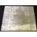
LEWIS'S NEW TRAVELLERS GUIDE FOR A POCKET EDITION OF THE ENGLISH COUNTIES CONTAINING ALL THE
LEWIS'S NEW TRAVELLERS GUIDE FOR A POCKET EDITION OF THE ENGLISH COUNTIES CONTAINING ALL THE DIRECT AND CROSS ROADS IN ENGLAND AND WALES, London, ...
One box: collection of UK Survey
One box: collection of UK Survey
One box: SURVEY OF ENGLISH DIALECTS, 12 vols (A) intro (B) basic material vol 1 SIX NORTHERN
One box: SURVEY OF ENGLISH DIALECTS, 12 vols (A) intro (B) basic material vol 1 SIX NORTHERN COUNTIES AND THE ISLE OF MAN, 1, 2, 3, vol 2 THE WEST...
Rolled copy of map of the Parish of Deptford, St Nicholas and St Paul 1844 + cloth backed road map
Rolled copy of map of the Parish of Deptford, St Nicholas and St Paul 1844 + cloth backed road map of England and Wales
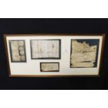
Circa 1728 bar tab and three receipts taken from an 18th century timber framed cottage on the
Circa 1728 bar tab and three receipts taken from an 18th century timber framed cottage on the Walpole Road, Suffolk that once operated as a lodge ...
![ROBERT MORDEN: COMITATUS DEN ROTLANDIAE TABULA NOVA AUCTA [RUTLAND], engraved map [circa 1695],](https://portal-images.azureedge.net/auctions-2020/srkey10319/images/72561fef-b9f1-41b6-b2c7-ab5900e14325.jpg?w=155&h=155)
ROBERT MORDEN: COMITATUS DEN ROTLANDIAE TABULA NOVA AUCTA [RUTLAND], engraved map [circa 1695],
ROBERT MORDEN: COMITATUS DEN ROTLANDIAE TABULA NOVA AUCTA [RUTLAND], engraved map [circa 1695], framed and glazed, approx size 370 x 290mm ...[mo...
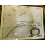
CAPT. GREENVILE COLLINS: YARMOUTH AND THE SANDS ABOUT IT, engraved hand coloured sea chart [circa
CAPT. GREENVILE COLLINS: YARMOUTH AND THE SANDS ABOUT IT, engraved hand coloured sea chart [circa 1693], framed and glazed, approx size 570mm x 45...
ROBERT SAYER: A NEW ROYAL GEOGRAPHICAL PASTIME FOR ENGLAND AND WALES, hand coloured engraved map,
ROBERT SAYER: A NEW ROYAL GEOGRAPHICAL PASTIME FOR ENGLAND AND WALES, hand coloured engraved map, 1787, backed onto linen, approx 675 x 545mm
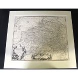
CLAUDE DU BOSE: A MAP OF FLANDERS AND OTHER PROVINCES OF THE NETHERLANDS WITH PART OF ENGLAND,
CLAUDE DU BOSE: A MAP OF FLANDERS AND OTHER PROVINCES OF THE NETHERLANDS WITH PART OF ENGLAND, HOLLAND, FRANCE ETC, engraved map circa 1735, appro...
![PHILIP LEA: NORFOLK DESCRIBED BY C SAXTON [CIRCA 1689], hand coloured engraved map, approx 495 x](https://portal-images.azureedge.net/auctions-2020/srkey10319/images/2389204d-54a7-4ba9-af0f-ab5900d9471a.jpg?w=155&h=155)
PHILIP LEA: NORFOLK DESCRIBED BY C SAXTON [CIRCA 1689], hand coloured engraved map, approx 495 x
PHILIP LEA: NORFOLK DESCRIBED BY C SAXTON [CIRCA 1689], hand coloured engraved map, approx 495 x 350mm
![ROBERT MORDEN: NORFOLK, hand coloured engraved map [1695], approx 595 x 395mm](https://portal-images.azureedge.net/auctions-2020/srkey10319/images/0cb58574-f4ab-421e-9fc9-ab5900d94acf.jpg?w=155&h=155)
ROBERT MORDEN: NORFOLK, hand coloured engraved map [1695], approx 595 x 395mm
![J CARY: A MAP OF NORFOLK FROM THE BEST AUTHORITIES, hand coloured engraved map [1789], approx 405](https://portal-images.azureedge.net/auctions-2020/srkey10319/images/5990e0be-704f-4486-885f-ab5900d94db5.jpg?w=155&h=155)
J CARY: A MAP OF NORFOLK FROM THE BEST AUTHORITIES, hand coloured engraved map [1789], approx 405
J CARY: A MAP OF NORFOLK FROM THE BEST AUTHORITIES, hand coloured engraved map [1789], approx 405 x 520mm
CHARLES SMITH: A NEW MAP OF THE COUNTY OF NORFOLK DIVIDED INTO HUNDREDS, hand coloured engraved map,
CHARLES SMITH: A NEW MAP OF THE COUNTY OF NORFOLK DIVIDED INTO HUNDREDS, hand coloured engraved map, 1801, backed onto board, approx 445 x 495mm
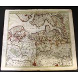
NICOLAES VISSCHER: FLANDRIAE COMITATUS PARS BATAVA..., hand coloured engraved map of North Belgium [circa 1690], closed marginal tears to the cent...
![EDWARD STANFORD: CEYLON, coloured map [circa 1890], approx 750 x 565mm](https://portal-images.azureedge.net/auctions-2020/srkey10319/images/556d91a0-f972-4f0b-bd14-ab5900d95807.jpg?w=155&h=155)
EDWARD STANFORD: CEYLON, coloured map [circa 1890], approx 750 x 565mm
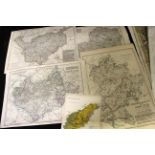
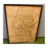
Approx 34 county maps including CHESHIRE, BEDFORDSHIRE, NORTHUMBERLAND, BERKSHIRE, HEREFORDSHIRE,
Approx 34 county maps including CHESHIRE, BEDFORDSHIRE, NORTHUMBERLAND, BERKSHIRE, HEREFORDSHIRE, HAMPSHIRE, DEVONSHIRE etc, approx 820 x 540mm
![EDWARD WELLER: ATLAS OF THE BRITISH ISLES, London, Cassell, Petter & Galpin [circa 1860s], 48pp of](https://portal-images.azureedge.net/auctions-2020/srkey10319/images/b9d88240-da32-42a9-89dc-ab5900d9649d.jpg?w=155&h=155)
EDWARD WELLER: ATLAS OF THE BRITISH ISLES, London, Cassell, Petter & Galpin [circa 1860s], 48pp of
EDWARD WELLER: ATLAS OF THE BRITISH ISLES, London, Cassell, Petter & Galpin [circa 1860s], 48pp of outlined in colour county maps (3 with closed m...
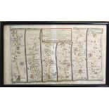
THOMAS GARDNER: THE ROAD FROM IPSWICH...TO NORWICH... TO ALESHAM, engraved hand coloured road map,
THOMAS GARDNER: THE ROAD FROM IPSWICH...TO NORWICH... TO ALESHAM, engraved hand coloured road map, circa 1719, approx 164 x 265mm, framed and glaz...
THOMAS WALPOLE: A NEW MAP OF SUFFOLK DRAWN FROM THE LATEST AUTHORITIES, hand coloured engraved
THOMAS WALPOLE: A NEW MAP OF SUFFOLK DRAWN FROM THE LATEST AUTHORITIES, hand coloured engraved map [1784], framed and glazed, approx size 195 x 15...
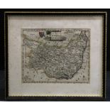
![ROBERT MORDEN: DORSETSHIRE, hand coloured engraved map, [1753], framed and glazed, approx size 440 x](https://portal-images.azureedge.net/auctions-2020/srkey10319/images/e557f049-be1f-43ea-ad49-ab5900e144c1.jpg?w=155&h=155)
ROBERT MORDEN: DORSETSHIRE, hand coloured engraved map, [1753], framed and glazed, approx size 440 x
ROBERT MORDEN: DORSETSHIRE, hand coloured engraved map, [1753], framed and glazed, approx size 440 x 370mm ...[more]
SMITH'S NEW AND ACCURATE MAP OF THE LAKES IN THE COUNTIES OF CUMBERLAND, WESTMORLAND AND LANCASTER, part hand coloured engraved map,1800, framed a...
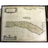
TIMOTHY PONT: CANTYRA CHERSONESUS, engraved hand coloured map, circa 1654, engraved by W Blaeu,
TIMOTHY PONT: CANTYRA CHERSONESUS, engraved hand coloured map, circa 1654, engraved by W Blaeu, approx 410 x 500mm, framed and glazed ...[more]